U.S. Temperature Highlights - Summer
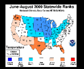
- For the 2009 summer, the average temperature of 71.7 degrees F was 0.4 degree F below the 20th Century average. The 2008 average summer temperature was 72.7 degrees F.
- A recurring upper level trough held the June-August temperatures down in the central states, where Michigan experienced its fifth, Wisconsin, Minnesota, and South Dakota their seventh, Nebraska its eighth, and Iowa its ninth coolest summer. By contrast, Florida had its fourth warmest summer, while Washington and Texas experienced their eighth and ninth warmest, respectively.
- The Michigan, Wisconsin, Iowa and Minnesota region experienced its sixth coolest summer on record. Only the Northwest averaged above normal temperatures.
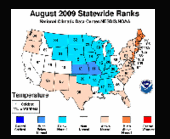
- The average 2009 August temperature of 72.2 degrees F was 0.6 degree F below the 20th Century average. Last year's August temperature was 73.2 degrees F.
- Temperatures were below normal in the Midwest, Plains, and parts of the south. Above-normal temperatures dominated the eastern seaboard, areas in the southwest, and in the extreme northwest.
- Several northeastern states were much above normal for August, including Delaware and New Jersey (eighth warmest), Maine (ninth), and Rhode Island and Connecticut (10th). In contrast, below-normal temperatures were recorded for Missouri and Kansas.
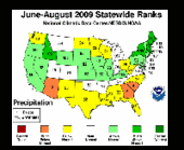
- The Northeast region had its eighth wettest June-August summer on record. By contrast, the South, Southeast and Southwest regions, were drier than average. Arizona had its third driest summer, while both South Carolina and Georgia had their sixth driest.
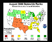
- In August, precipitation across the contiguous United States averaged 2.34 inches, which is 0.26 inch below the 1901-2000 average.
- Above-normal averages were generally recorded across the northern U.S., west of the Great Lakes. The South and Southeast regions experienced below-normal precipitation.
- Precipitation across the Southwest region averaged 0.85 inches, which is 1.10 inches below normal and ranks as the 4th driest August on record. Arizona had its fourth driest, New Mexico its fifth, and it was the eighth driest August on record for Colorado, Utah and Texas.
- By the end of August, moderate-to-exceptional drought covered 14 percent of the contiguous United States, based on the U.S. Drought Monitor. Drought intensified in parts of the Pacific Northwest and new drought areas emerged in Arizona and the Carolinas. Montana, Wisconsin and Oklahoma saw minor improvements in their drought conditions.
- About 27 percent of the contiguous United States had moderately-to-extremely wet conditions at the end of August, according to the Palmer Index (a well-known index that measures both drought intensity and wet spell intensity).
- There were more than 300 low temperature records (counting daily highs and lows) set across states in the Midwest during the last two days of August.
- A total of 7,975 fires burned 1,646,363 acres in August, according to the National Interagency Coordination Center. August 2009 ranked fifth for the number of fires and sixth for acres burned in August this decade. From January through August, 64,682 fires have burned 5.2 million acres across the nation.
NOAA understands and predicts changes in the Earth's environment, from the depths of the ocean to the surface of the sun, and conserves and manages our coastal and marine resources.


Reader Comments
to our Newsletter