Storms
S


Snowflake Cold

Southern Ontario braces for biggest snowstorm in years

Image
© CBC News
The Friday morning commute is looking to be an ugly one for Southern Ontario as the Alberta Clipper swinging through the area today is amplified by moisture from another storm system moving up from the United States.

"It might be the biggest storm since 2011," said Rob Khun, a severe weather meteorologist with Environment Canada, referring to the March 2011 storm that dumped 12.5 cm of snow on the GTA.

Snow from the storm system has begun to fall in southwestern Ontario this morning as the Alberta Clipper tracks through the area, and it should arrive in the GTA by this afternoon. This will leave about 2 cm of accumulation on the ground, however the added moisture arriving from the south this evening will turn this to heavy snowfall overnight and into Friday morning.

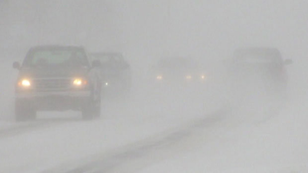
Total accumulations for southern Ontario are expected to be between 15 and 25 cm of snow, and strong winds will add blowing snow to the mix, making for hazardous driving conditions tonight, through the Friday morning commute, and possibly into tomorrow afternoon as well.

Eastern Ontario is expected to be even harder hit, as snowfall accumulations already forecast to be up to 25 cm from the Alberta Clipper are pushed up to 35 cm or higher by the approaching storm from the south and local amplification due to winds blowing in off of Lake Ontario.

Environment Canada has issued Snowfall Warnings from London-Essex to Kingston-Prince Edward regions, and from Niagara region up into Grey-Bruce along the shores of Lake Huron and Georgian Bay.
Snowflake

Monster blizzard Nemo headed for U.S. Northeast

Blizzard_1
© Kelly Keene
A significant snowstorm is expected, which can be compared to the 1978 blizzard. Snowfall could exceed two feet (.6 meters) in some areas.

The northeastern United States is preparing for a monster storm, which many are calling Nemo, expected on February 8, 2013. It could easily produce over two feet of snow (.6 meters) and wind gusts over 60 miles (96 km) per hour, causing zero visibility and bringing cities to a standstill.

In many ways, we are looking at an historic storm that could paralyze cities such as Boston, Providence, and Hartford. We're expecting blizzard conditions in eastern and southeastern Massachusetts, Connecticut, Rhode Island, Northeastern New Jersey, Long Island, southeastern Maine, and New York City.

Moderate to major coastal flooding is also possible. Two storm systems will phase together to create a large pressure gradient that will result in winds sustaining around 35-50 mph with gusts over 74 mph. Tonight is the last night to get ready for a significant snowstorm that can be compared to the 1978 blizzard.
Blizzard
© Google/NWSBlizzard warnings are in effect for parts of the Northeast.

Snowflake

New England blizzard - one for the books? Major winter storm on its way

New England blizzard: Forecasters are predicting more than 2 feet of snow in New England, and blizzard conditions, including high winds, blowing snow, and coastal flooding. A major winter storm heading toward New England may not be one for the record books, but even some of the nation's snow-hardiest people should proceed with caution, according to at least one expert.
Image
The National Weather Service forecasts blizzard conditions in New England by late Friday afternoon.
As much as 2 feet of snow could fall on a region that has seen mostly bare ground this winter, the National Weather Service said. That's exciting for resort operators who haven't had much snow this year.

The storm would hit just after the 35th anniversary of the historic blizzard of 1978, which paralyzed the region with more than 2 feet of snow and hurricane force winds from Feb. 5-7.

"This has the potential for being a dangerous storm, especially for Massachusetts into northeast Connecticut and up into Maine," said Louis Uccellini, director of the weather agency's National Centers for Environmental Prediction.

Snowflake

Powerful storm to dump foot of snow this weekend on U.S. East Coast as region braces for coastal storm

A powerful coastal storm could dump as much as a foot of snow on areas of the East Coast this weekend. Though metropolitan areas along the East Coast have enjoyed a relatively mild winter with less than half of the average snowfall, a mix of snow, wind, and rain could change all of that come Friday and Saturday. Meteorologists say that a weather system from the Midwest will meet with one from the South, creating a storm that will deliver wind, snow, and rain.

The Weather Channel reports that the Midwestern storm pattern, which passed through Chicago and Milwaukee, will mix with wetter weather coming from New Orleans, Louisville, and even Atlanta. By Thursday night, forecasts predict that the clipper system will travel from the Great Lakes region to the East Coast, passing through cities like Philadelphia, New York, and up towards Boston.
Image

Ice Cube

Snowiest winter in 100 years paralyzes Moscow

Image
© RIA Novosti / Denis Tyrin
The snowiest winter in a century has hit the Russian capital, causing Muscovites to get stuck in traffic jams 3,500km in length on Monday evening - the distance from Moscow to Madrid.

­Since the beginning of the winter, over 2 meters of snow has fallen on the Russian capital, the Moscow mayor's aide in housing and public utilities Pyotr Biryukov told Interfax. Snowfall is expected in Moscow for four or five more days, he added.

On Monday, 45,000 community services employees and 15,000 units of equipment were attempting to cope with 26 cm of snow - nearly a fifth of the average annual fall.

The latest snowfall has become a nightmare for drivers with the capital's commuters trapped in gridlock.

Many of those who left their workplace in the evening had to spend five to 10 hours getting home. The average speed of vehicles was no more than 7-9 km/h. The number of road accidents - 3,000 - was much higher than during an ordinary day, with minor accidents quadrupling, according to Channel One TV.

Bizarro Earth

Nine people killed as freak hailstorm rains massive boulders down on Indian villages

Hailstones the size of boulders have rained down on villages in southern India.At least nine people were killed when the violent weather hit several villages in the state of Andhra Pradesh. The hailstorm which lasted for almost 20 minutes, destroyed crops, houses and live stock, causing devastating financial implications for residents.
Freak Hailstorm_1
© Mohammed Aleemuddin/Barcroft lRaining down: People cleaning the streets covered with large boulders of hailstorm Andhra Pradesh, India.

Saturn

Cassini watches storm on Saturn choke on its own tail

cassiniwatch
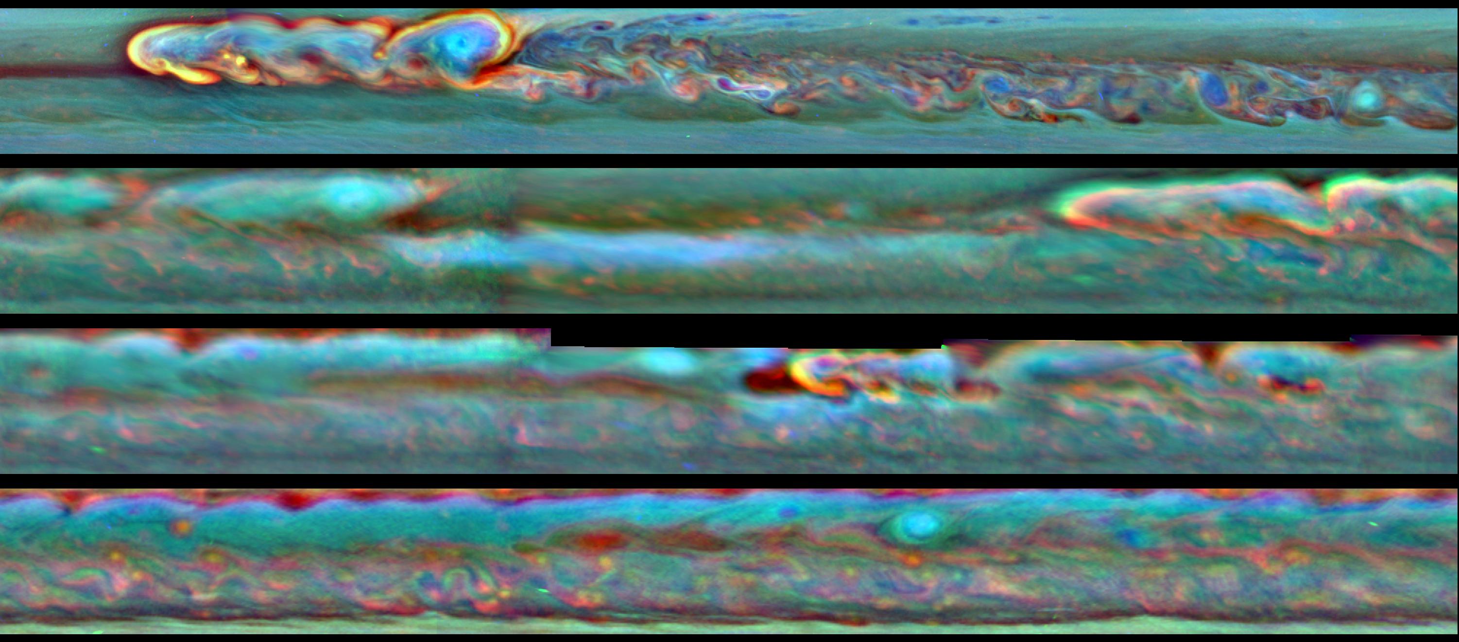
© NASA/JPL-Caltech/SSI/Hampton UniversityThis set of images from NASA's Cassini mission shows the evolution of a massive thunder-and-lightning storm that circled all the way around Saturn and fizzled when it ran into its own tail. The storm was first detected on Dec. 5, 2010. That month, it developed a head of bright clouds quickly moving west and spawned a much slower-drifting clockwise-spinning vortex.
Call it a Saturnian version of the Ouroboros, the mythical serpent that bites its own tail. In a new paper that provides the most detail yet about the life and death of a monstrous thunder-and-lightning storm on Saturn, scientists from NASA's Cassini mission describe how the massive storm churned around the planet until it encountered its own tail and sputtered out. It is the first time scientists have observed a storm consume itself in this way anywhere in the solar system.

"This Saturn storm behaved like a terrestrial hurricane - but with a twist unique to Saturn," said Andrew Ingersoll, a Cassini imaging team member based at the California Institute of Technology, Pasadena, who is a co-author on the new paper in the journal Icarus. "Even the giant storms at Jupiter don't consume themselves like this, which goes to show that nature can play many awe-inspiring variations on a theme and surprise us again and again."

Earth's hurricanes feed off the energy of warm water and leave a cold-water wake. This storm in Saturn's northern hemisphere also feasted off warm "air" in the gas giant's atmosphere. The storm, first detected on Dec. 5, 2010, and tracked by Cassini's radio and plasma wave subsystem and imaging cameras, erupted around 33 degrees north latitude. Shortly after the bright, turbulent head of the storm emerged and started moving west, it spawned a clockwise-spinning vortex that drifted much more slowly. Within months, the storm wrapped around the planet at that latitude, stretching about 190,000 miles (300,000 kilometers) in circumference, thundering and throwing lightning along the way.

Satellite

Satellite image shows Eastern U.S. severe weather system

A powerful cold front moving from the central United States to the East Coast is wiping out spring-like temperatures and replacing them with winter-time temperatures with powerful storms in between. An image released from NASA using data from NOAA's GOES-13 satellite provides a stunning look at the powerful system that brings a return to winter weather in its wake.

On Jan. 30 at 1825 UTC (1:25 p.m. EST), NOAA's GOES-13 satellite captured an image of clouds associated with the strong cold front. The visible GOES-13 image shows a line of clouds that stretch from Canada to the U.S. Gulf Coast and contain powerful thunderstorms with the potential to be severe. The front is moving east to the Atlantic Ocean.
Image
© NOAA/NASA/GOES Project
NOAA's GOES-13 satellite continually provides real-time visible and infrared imagery of weather over the eastern United States. The NASA GOES Project, located at NASA's Goddard Space Flight Center in Greenbelt, Md., created the image from GOES data. The colorized image uses GOES-13 satellite visible data of clouds, and is overlaid on a U.S. map created by imagery from the Moderate Resolution Spectroradiometer instrument (MODIS), an instrument that flies aboard both the NASA Aqua and Terra satellites.

Cloud Precipitation

State of Emergency declared in the Seychelles after tropical cyclone Felleng

Seychelles map
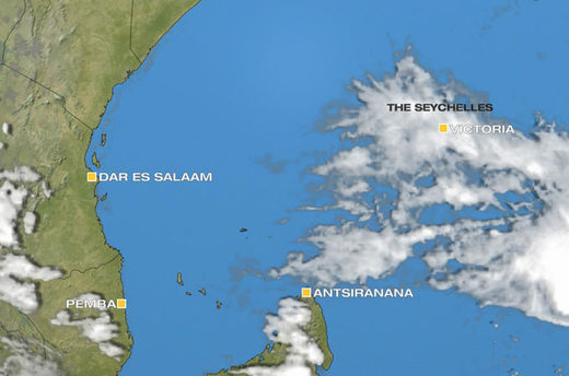
© Al JazeeraA state of emergency has been declared in three districts of Mahe, the largest island in the Seychelles
Flooding and landslides have destroyed well over a hundred houses on the main island of Mahe.

Parts of the Seychelles have been declared a state of emergency after severe weather hit the country.

Fortunately no casualties have been reported, but flooding, landslides and rock falls have hit the main island of Mahe. Over 150 houses have been damaged by the extreme conditions.

Pointe Au Sel in the southeast of the island reported 184mm of rain in a 24 hour period. This is nearly half the amount of rain which is expected in the entire month of January, which is the wettest month of the year.

Many other parts of the island also received well over 100mm, easily enough to generate flooding. With the ground fully saturated, landslides were inevitable.

Windsock

Tropical cyclone Felleng strongest of the season so far

Cyclone Felleng
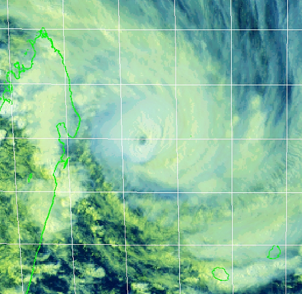
© Joint Typhoon Warning CenterCategory-4 equivalent Tropical Cyclone Felleng as of 1130 UTC Wednesday, Jan. 30, 2013. To the west lies Madagascar; Reunion and Mauritius to the southeast (lower right).
Tropical Cyclone Felleng has become the strongest cyclone of the South Indian 2012-2013 storm season and the strongest storm in this tropical cyclone region since last February.

Highest sustained winds rose to an estimated 115 knots, or about 215 km/h, as of 1200 UTC Wednesday, the Joint Typhoon Warning Center (JTWC) said.

The dangerous storm, equivalent to a Category-4 hurricane, was centered less than 400 miles northwest of Reunion and within 360 miles east-northeast of Antananarivo, Madagascar. Storm movement was towards the south-southwest 13 knots, or 24 km/h.

Official forecasts tracking Felleng have been consistent since the first of the week, inasmuch as they have shown the southward-veering cyclone tracking "safely" between Madagascar and Reunion before racing southward over open water.