Volcanoes
S


Bizarro Earth

El Salvador's Chaparrastique volcano continues to show significant levels of internal seismic activity

The Chaparrastique volcano near San Miguel, El Salvador continues to show significant levels of internal seismic activity. Authorities are on a high level of preparedness should actions be needed. The activity since yesterday has been at the highest levels seen. The chart below shows activity during July -- the average, normal level is 50, and current levels are above 1100.
Image
This graphic shows the location of micro-quakes on the northern slopes of the volcano:
Image

Bizarro Earth

Costa Rica's 'extinct' Chata volcano being re-examined for activity

Image
Volcanologists of the National Seismological Network (RSN) have begun early research on the Chato volcano, located southeast of Poas volcano, to find out information such as its last eruption. RSN volcanologist, Gino Gonzalez, said that measurements of the temperature of the lagoon taken by sonar instrumentation, determining that the surface of the lake is about 19°C and approximately 6 meters deeper the temperature of the lagoon varies drastically.

"It's a volcano which very little is known about its historical activity, so we have seismic stations for periodic sampling and we are starting a campaign to closely monitor it every six months," Gonzalez said. Chato is considered an extinct volcano according to the authorities who made the first sampling to verify the behavior and activity.

According to volcanologist at greater depths there is an increase in the amount of dissolved oxygen in the lake, which could be due to a strong photosynthetic activity, consistent with high turbidity or gas accumulation at deeper levels. The maximum depth of the lake is around 18 meters, averaging 15 meters.

Phoenix

Hot spot: Yellowstone road melts, sites closed

Yellowstone
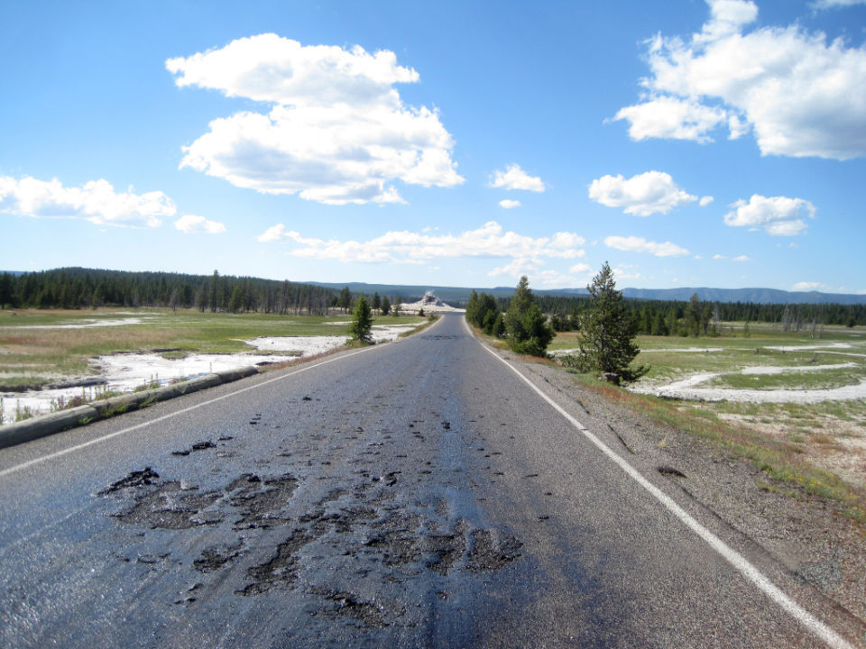
© National park ServiceFirehole Lake Drive superheated by surrounding thermals
The ever-changing thermal geology of Yellowstone National Park has created a hot spot that melted an asphalt road and closed access to popular geysers and other attractions at the height of tourist season, officials said Thursday.

As they examined possible fixes, park officials warned visitors not to hike into the affected area, where the danger of stepping through solid-looking soil into boiling-hot water was high.

"There are plenty of other great places to see thermal features in the park," Yellowstone spokesman Al Nash said. "I wouldn't risk personal injury to see these during this temporary closure."

Naturally changing thermal features often damage Yellowstone's roads and boardwalks. Steaming potholes in asphalt roads and parking lots - marked off by traffic cones - are fairly common curiosities.

However, the damage to Firehole Lake Drive is unusually severe and could take several days to fix. The 3.3-mile loop six miles north of Old Faithful takes visitors past Great Fountain Geyser, White Dome Geyser and Firehole Lake.

Unusually warm weather for Yellowstone - with high temperatures in the mid-80s - has contributed to turning the road into a hot, sticky mess.

"We've got some ideas. We're going to try them. Our maintenance staff has really looked at the issue," Nash said.
Sherlock

Deep in the Antarctic ice, the history of planet's biggest volcanic explosions

Image
© Independent
Scientists have been able to trace the history of volcanic eruptions over the last 2,000 years by analysing deposits of sulphate dust in a series of ice cores drilled deep into the West Antarctic ice sheet

Some of the biggest volcanic eruptions of the last 2,000 years have left their indelible mark deep within the pristine ice sheet of the Antarctic, a study has found.

Scientists have been able to trace the most complete history of volcanic eruptions since the birth of Christ by analysing deposits of sulphate dust in a series of ice cores drilled deep into the West Antarctic ice sheet.

The time series from 26 separate ice cores drilled out from 19 different sites shows that there were 116 volcanic eruptions in the past two millennia that were big enough to result in plumes of volcanic sulphate dust being transported as far as the South Pole.

Most the eruptions cannot be identified, however the biggest, in 1257, was already hinted at from medieval chronicles and tree rings. Scientists identified the sulphate deposits as coming from the Samalas volcano on Lombok Island of Indonesia.

Bizarro Earth

Kamchatka volcano spews new ash plume 8 km into sky

Shiveluch Volcano
© Vesti.Ru
Shiveluch, one of the largest and most active volcanos of Russia's far-eastern Kamchatka Peninsula, has spewed a plume of ash as high as 8 km into the air, the Kamchatka Emergency Service reported on Sunday.

"The wind is driving the ash cloud southeastwards. There are no populated centers along its path," the report says.

Although no ash fallouts have been registered in the Ust-Kamchatsky district, rescuers have recommended tourist operators to cancel tours in the vicinity of the volcano. The orange-level volcanic alert has been issued for aircraft flying over the peninsula.

It's the second ash plume ejected by Shiveluch since the beginning of July. On July 1, a cloud of ash shot up 7 km above sea-level. The town of Klyuchi with a population of 5,000 is the nearest community to the 2,500-high volcano, 45 km away from it.

After Shiveluch intensified in May 2009, a crack about 30 m deep appeared in its dome.

Bizarro Earth

New lava activity at Hawaiian volcano

Puu Oo
© West Hawaii Today/Hawaiian Volcano ObservatoryLava flows from the northeast flank of Puu Oo on Friday.
There's new activity at Puu Oo crater. On Friday morning, lava broke out at four locations on the crater's northeast flank, producing a channel flow that had traveled nearly a mile as of 11 a.m. that day. The northeast flow remained active Saturday morning, geologists at the Hawaiian Volcano Observatory reported.

The event began when the crater floor subsided, causing a collapse of spatter cones, which revealed small lava ponds inside. Geologists attributed the event to magma accumulating in a mostly horizontal layer about 1,640 feet below the crater, located along Kilauea's east rift zone.

The new flow may have had an impact on the Kahaualea 2 flow, which extends 4.4 miles northeast of the crater, according to HVO.

"From this morning's webcam views, it's clear that the flow is still hot but is far less active than prior to the June 27 collapse," the observatory reported Saturday. "We should know with more certainty over the next few days whether the Kahaualea 2 flow has stalled."

Bizarro Earth

Indonesia's Mount Sinabung erupts, causing massive evacuation

Image
Mount Sinabung November 2013 eruption
Powerful burst of hot ash erupted from one of the most active volcanoes in Indonesia, Mount Sinabung in Karo district of North Sumatra, on Sunday evening, triggering massive evacuation, official disclosed here.

The eruption occurred only months after the volcano had erupted intermittently from September to February which left 15 people dead, more than 30,000 other internally displaced and a warning to aviation.

Sunday's eruption occurred at 19:29 p.m. Jakarta time (1229 GMT) with 4,000 meter high column of ash spewed to the sky, Sutopo Purwo Nugroho, spokesman of national disaster agency said.

Arrow Up

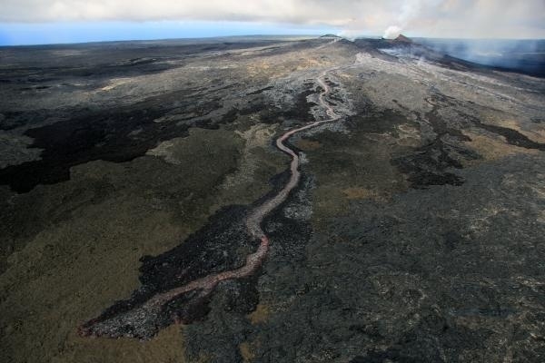
Hawaii: World's largest active volcano shows signs of life

dark clouds, volcano eruption
© www.hawaiipictures.com"Ash and Fire," Mauna Loa
Mauna Loa, the world's largest active volcano, has rumbled back to life in Hawaii over the past 13 months with more seismic activity than at any time since its last eruption, scientists say, while calling it too soon to predict another blast. The volcano, which last erupted in 1975 and 1984, has been rattled since March 2013 by earthquakes of the same type and in the same location as the temblors that preceded those explosions, said Wes Thelen, a seismologist for the US Geological Survey's Hawaiian Volcano Observatory.

"The earthquakes we are seeing at Mauna Loa lead us to believe that some of the same things that happened before the 1975 and 1984 eruptions are happening right now," Thelen told Reuters. "We don't see this kind of activity outside of pre-eruptive earthquake sequences," he said.

The USGS posted a photo of Mauna Loa on Instagram on Wednesday with the caption: "After a 30-year repose, this sleeping giant may be stirring slowly to life."

Thelen said the earthquakes so far had not been regular or sustained enough to lead the observatory to forecast an eruption or raise the color-coded volcano warning system. But seismologists were keeping a close eye on the volcano.

Comment: Previously thought to be extensions of a single volcano, Mauna Loa is actually flanked by a curving line of individual volcanoes that include Kilauea, Mauna Kea and Kohala. Its summit is 56,000 feet above its base on the sea floor. Four distinct earthquake swarms have occurred since March 2013, all less than magnitude 2.2, save one that registered 3.5 on May 9, 2014, and have been occurring in the same areas of the volcano as those in the years prior to 1984. They are, so far, consistent with a model requiring rocks around the core to adjust to stress changes within the core. While Mauna Loa is not located along the Ring of Fire, it is likely that whatever disturbances and earth changes provoking recent Pac Rim activity are also escalating changes in other areas under the ocean.


Attention

Aleutian volcanoes in Alaska are waking up

Alaska volcanoes
Screen shot from the Alaska Volcano Observatory's website.
Sharply increased seismic activity and volcanic eruptions in the Aleutian Islands and the far western Brooks Range are being investigated by scientists.

The Alaska Volcano Observatory says the activity over the past few months is the most seen by the station 26 years.

On the Alaska Volcano Observatory website three volcanoes are classified with a yellow alert level - signifying signs of elevated unrest above known background levels - and three are at an orange alert level - heightened unrest with increased likelihood of eruption.

Orange is the second-highest alert level after red signifying an eruption that is imminent or underway.

Attention

Reunion Island volcano erupts again after four years

Reunion volcano
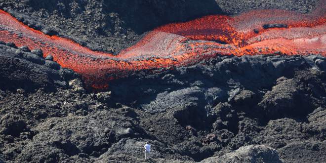
© Richard Bouhet/AFP/Getty ImagesA picture taken on June 21, 2014 shows lava flowing out of the Piton de la Fournaise volcano, one of the worldThis morning at 1:35 am tourists on the French Indian Ocean Islands La Reunion tourists witnessed a spectacular many had been waiting to see for some time. The Piton de la Fournaise volcano erupted.
This morning at 1:35 am tourists on the French Indian Ocean Islands La Reunion tourists witnessed a spectacular many had been waiting to see for some time. The Piton de la Fournaise volcano erupted.

"It made a few days that we were waiting for it, said Pascal Viroleau, CEO of Reunion Island Tourism, about the eruption of the volcano of Reunion Island, the Piton de la fournaise. According to Viroleau, "the volcano entered in activity this morning at 1:35 am."

Most recently, an eruption occurred on December 9, 2010 and lasted for two days. The volcano is located within Réunion National Park, a World Heritage site. It is considered one of the major attractions of the Indian Ocean Vanilla Islands.

"Sleeping since December 2010," Piton de la fournaise is considered as one of the major attractions of the Indian Ocean Vanilla Islands.