Volcanoes
S


Bizarro Earth

US: Magma plume - profuse lava flow from Kīlauea breaches West Ka'ili'ili ocean entry for the first time in 4 years

Image
© Hawai‘i Volcanoes National Park
This media release is from the Hawaii Volcanoes National Park

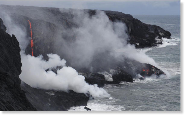
Lava from Kīlauea's remote Pu'u 'Ō'ō vent has again reached the ocean within Hawai'i Volcanoes National Park boundaries, at a spot scientists have named the West Ka'ili'ili ocean entry.

The arduous hike to West Ka'ili'ili from the bottom of Chain of Craters Road is approximately four miles one-way across an uneven flow field. Currently, several streams of lava are pouring into the ocean, providing dramatic views. Visitors who stay after dark can also see channels of lava flowing down the pali and across the flow field, but conditions can change at any time.

Hikers need to heed all warning signs and ranger advisories, and be aware of earth cracks and crevices, sharp terrain and rain-slick pāhoehoe lava and other hazards. Steam plumes produced by lava entering the sea contain fine lava fragments and acid droplets that can be harmful. Scientists also confirmed that a lava delta is being formed at the base of a sea cliff at West Ka'ili'ili, and are monitoring the area closely. Lava deltas can collapse with little warning, produce hot rock falls inland, and generate large local waves.
Bizarro Earth

Myanmar - Rise of Underground Water Temperature Causes Volcano Mud Eruptions

Chiang Mai - An earthquake in Rakhine State has caused underground water temperatures to rise, setting off volcano eruptions of mud and small amounts of lava.

Erupting Volcano
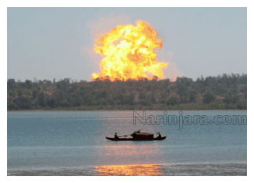
© NarinjaraA volcano erupting in the Kyaukphyu area in 2008.
Retired geologist Soe Thein said volcanos in the Kyaukphyu Township area on Ramree Island were set off along a fault line. More volcano mud eruptions might occur, he said, but there is no danger or need for mass evacuations.

"When there is earth crust movement in these fault lines, there will be underground water circulation and more water will move up to the surface as hot springs, but they are not like real volcanoes. They do not pose a danger to people," Soe Thein said.

The highest number of underground hot spring fault lines is in Kyaukphyu Township. The hot spring fault line runs through Magwe Region.

A mud volcano erupted on November 26 on a small hill one mile west of Bawyabaya village, about 32 miles from Kyaukphyu. The eruption sent magma and lava 15-feet into the air, and about 5 acres of nearby land was covered by magma.

Bizarro Earth

Hawaii's Volcano Kilaueu erupting

Check out this amazing video from Hawaii's Big Island. You're looking at red hot lava spewing out of the Kilauea Volcano. You can see it's sparking small fires and consuming trees as it moves down this incline.


Attention

Four villages evacuated as volcano begins to erupt in Ecuador

Tungurahua erruption
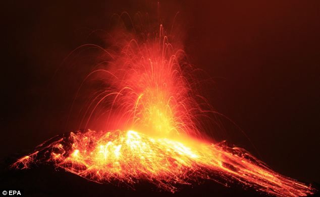
© EPAViolent eruptions: The molten heart of the Tungurahua volcano, near Quito in Ecuador, as it begins to spew out lava and hot gas
Four Ecuadorean villages are being evacuated after a volcano close to the country's capital began spewing smouldering rock and billowing columns of ash.

The government is urging 700 people living beside the Tungurahua volcano near Quito to leave the area as soon as possible.

Tungurahua - which means 'Throat of Fire' in the indigenous Quechua language - has been active since 1999 but began erupting violently on Sunday, sending red-hot clouds of gas up into the atmosphere.

Bizarro Earth

Indonesia: Is the Anak Krakatau Volcano About to Blow?

anak krakatau
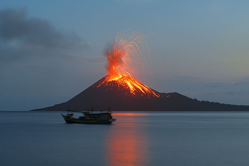
© swisseduc.chEruption at Anak Krakatua in 2009.
Indonesia's Mount Anak Krakatau volcano has been puffing white smoke the last few days, and scientists are warning locals and tourists to keep away. That could mean that the long suspected eruption of the world's most famous volcano could be imminent.

Actually, this volcano is the remnant of the biggest blast ever recorded on Earth. That was the 1883 eruption of Mount Krakatoa. From the ruins of that gigantic crater left in the land has come forth what is now known as the Anak Krakatau volcano - literally "Krakatoa's Child."

In the time since the original eruption, scientists have gotten much better at predicting when a volcano will have a catastrophic eruption, distinguishing it from the many smaller eruptions which do not harm the local population or environment.

One of the telltale signs is sudden and increased activity like what scientists are seeing in this past week at the Anak Krakatau volcano.

Bizarro Earth

Fuego volcano - Guatemala: increasing explosive activity, ash plumes up to 2 km high

Image
© UnknownFuego Volcano
The Guatemalan geophysical survey SERNAGEOMIN reports increasing explosive activity from Fuego volcano, one of the country's most active volcanoes. Fuego was observed producing ash clouds reaching 1500-2000 m above the summit crater (at ca. 3600 m altitude) which drifted SW and reached up to 20 km distance where they produced some ash fall, reported in the communities of Panimaché, Morelia, Sangre de Cristo, and Santa Sofía.

The explosions were accompanied by moderate to strong booming noises and shock waves that could be felt in up to 15 km distance. Near-constant rock avalanches are observed on the upper slopes beneath the summit crater, some of which reach the vegetated areas.

Bizarro Earth

Volcano Near Mexico City Spews Ash, Smoke

Image
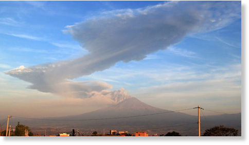
© APA large plume of ash rises from the Popocatepetl volcano as seen from the highway to Atlixco, Mexico early Friday, June 3, 2011.
Mexico's largest active volcano has spewed ash and smoke into the air on Sunday, and local civil protection authorities warned people not to go close as burning ash could fall for hours, reported China's Xinhua news agency.

The Popocatepetl volcano, 60 kilometres (km) southeast of Mexico City, were clearly visible from the capital and nearby cities of Puebla, Morelos and Mexico State.

Access to the volcano has been restricted to a radius of 12 km around the crater following a powerful explosion, which was reported at 12:05 p.m. local time (1805 GMT).

The explosion caused the earth to shake and sent smoke and ash over 7 km high into the air, and has alarmed some 20 million people living nearby.

However, officials said that no casualties or damages had been reported so far, Xinhua reported.

The Popocatepetl volcano is 5,452 meters high and located in the Trans-Mexican Volcanic Belt.

Bizarro Earth

Restless underwater volcano disrupts life on Canary Island

Image
© Guardia Civil
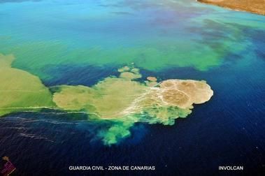
Madrid - Steaming magma is bubbling onto the sea surface. The earth shakes, and a smell of sulphur floats in the air.

For over a month, residents of the Spanish Canary Island of El Hierro have lived with an active underwater volcano that not only poses a security threat, but also scares off tourists and endangers the inhabitants' livelihoods.

Volcanic eruptions could continue for weeks, civil protection science representative Carmen Lopez said this week.

However, the situation has been deemed safe enough for the 550 evacuated residents of the fishing village of La Restinga to return home, though the island was still being hit by earthquakes.

The earth began trembling on El Hierro on July 19, in a sign that magma was rising toward the surface of the smallest Canary Island.

Attention

Italy: Etna erupts for eighteenth time this year

Mt. Etna
© Dr. Boris BehnckeStrombolian activity at Etna as seen on July 5, 2011.
Etna has intensified its activity today with fountains of lava and ash causing restrictions to air traffic. This eighteenth eruption this year has followed the Stromboli pattern as previous ones did and lasted just a couple of hours. The Crisis Unit at the Catania Fonatanrossa Airport met to assess potential consequences for flights and restricted air space until 16.30 without however affecting passenger flights.

Bizarro Earth

US: Hawaii's Kilauea Volcano Lava lake sinks, spurring quakes

Image
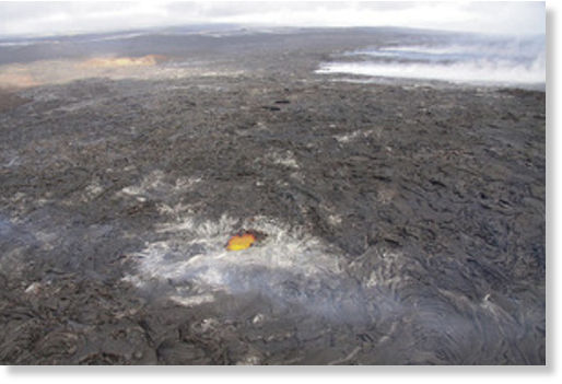
© Hawaiian Volcano ObservatoryA large "skylight" in the Puu Oo lava field permits a view of a tube supplying lava to surface flows north of Royal Gardens subdivision. The tube, which heads southeast, is marked by the line of fume sources in the upper-right portion of the image.
Eight small earthquakes rocked Kilauea Volcano after the lava lake at the summit caldera dropped in elevation Sunday, U.S. geologists reported.

But that seismic shaking was actually below normal levels, they said.

The strongest quake was a magnitude 3.3 at 2:16 a.m. Sunday.

At Puu Oo, meanwhile, a "skylight" in the pahoehoe (smooth, ropy lava) field showed a tube transporting lava on the southeast flank to active flows about three miles to the south.

The active lava flows are within the Kahauale'a Natural Area Reserve, which remains closed to the public because of various hazards - including potentially lethal concentrations of sulfur dioxide - so they are visible only from the air.

But the glow from the vents and flows can be seen from the Hawaii County viewing area at Kalapana if weather conditions are right, said scientists with the U.S. Geological Survey.