Extreme Temperatures
S


Igloo

Snow and unseasonably cool weather hits New South Wales

Image
Snow has fallen across New South Wales and the ACT as a cold snap hits the region. The unseasonal weather saw residents in areas including the Blue Mountains and southern tablelands waking up to snow on Friday. There is also snow around Canberra, following the coldest October day there in more than 40 years. There was a maximum temperature of 8C in the Canberra area on Thursday, 11 degrees below the October average and the coldest since 1967. Overnight snow fell in the hills between Canberra and Bungendore and in areas around Goulburn and Crookwell to the north.

The Bureau of Meteorology said many areas could see snow, frost and hail as the result of a low pressure system moving across NSW. "We've had quite a few reports of snow. We're expecting snow down to 700m over many parts of the state," said meteorologist Julie Evans. There has been 2.5cm of snow on the ground reported at Nerriga, in the southern tablelands. In the Blue Mountains, snow has been falling between Blackheath and Katoomba.

Snowflake Cold

Snow causes havoc across eastern Australia -- Video


The Bureau of Meteorology says snow falls have occurred right along the Great Dividing Range and as far north as Queensland's Granite Belt.

At its height, snowfalls of 15 centimetres and wind damage cut roads and rail access to the upper Blue Mountains for more than six hours.

In the Blue Mountains, 300 cars were stranded by the mountain road closures.

But the SES's Jennifer Finlay says most of the 550 calls for help came from further to the south.

"The Illawarra south coast got hit pretty hard with lots of trees down a bit of roof damage, fortunately nothing too severe," she said.

Endeavour Energy reconnected more than 2,000 properties to power on Friday afternoon, but hundreds of outlying properties between Mount Victoria and Medlow Bath and in the Megalong Valley will not get power back until Saturday.

With temperatures predicted to get down to 3 degrees Celsius overnight, the company has urged people in areas where the power is out to check on neighbours who live alone.

Comment: Note how the meteorologist claims "it's not unprecedented" because there were similar conditions in 2008. Well that's alright then! Nothing to worry about!


Ice Cube

Surprise! Now there's more ice at South Pole than ever (So much for global warming thawing Antarctica!)

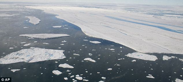
Ice around the South Pole has expanded to cover a record area, scientists revealed yesterday - a month after saying that the North Pole had lost an unprecedented amount of its ice. Researchers say - rather confusingly - that both occurrences are down to the 'complex and surprising' effects of global warming. The record Antarctic sea ice cover was revealed in satellite images from the US National Snow and Ice Data Center in Colorado.
Image
September 26, 2012, when ice covered more of the Southern Ocean than at any other time in the satellite record.
At the end of the southern winter in September, ice covered 7.51million square miles of sea - more than at any time since records began in 1979. For the last 30 years the amount of Antarctic sea ice has been increasing by 1 per cent each decade. While the rest of the world has been getting warmer over the last 50 years, large parts of the Eastern Antarctic have been getting cooler. Scientists say a cooler Antarctic fits in with the unpredictable nature of climate change.

Comment: For more on 'global warming', read: Climate Change Swindlers and the Political Agenda


Igloo

Australia storm gives rare snow: First October snow in a century


An unusually cold storm in southern Australia has dished out the first October snow in a century.

Snow whitened the ground along the Mount Lofty and southern Flinders ranges, east and north of Adelaide, South Australia, the Australian ABC News website said.

Images published Thursday on the ABC website showed snow-covered ground at Hallett, in an upland valley north of Adelaide. Posted videos showed falling snow in the hills east of Adelaide.

At low elevations, rain fell late Wednesday to early Thursday at temperatures in the lower to middle 40s, weather data available to AccuWeather.com showed.

Normal low temperature in Adelaide is about 50 degrees, whereas the typical high is in the lower 70s.

Snowflake

Arizona October Snow? Strong fall storm headed for northern Arizona

Image
A strong fall storm moving into Arizona on Thursday is expected to drop up to three inches of snow in the higher elevations. The National Weather Service said the greatest likelihood of severe storms will be from Thursday evening through Friday morning. Daytime temperatures Friday will be about 15-20 degrees cooler than earlier this week.

Up to three-quarters of an inch of rain is expected in some areas, with the possibility of tornadoes.

Forecasters said snow levels could drop to as low as 7,500 feet on Friday. The Kaibab Plateau, San Francisco Peaks and the White Mountains could see between one inch and three inches of snow.

Cloud Lightning

Shhhh, the Media doesn't want us to see this - "Some spots were 25-30 below normal, breaking record-cold lows. Some records over 100 years old!"

100-year-old cold records broken, but nary a word. "An incredible departure from normal happened with yesterday's lows out there," says reader Ralph Fato. "Some spots were 25-30 below normal, breaking record-cold lows. Some records over 100 years old!"
Image

Snowflake

Minnesota and North Dakota see new snowfall records and power outages in October

An early season snow event produced significant snow amounts for northeast North Dakota into northwest Minnesota for early October. The heaviest snow fell in Roseau county where around a foot of heavy wet snow has been reported as of 3 pm Thursday October 4. This heavy wet snow has also produced numerous power outages across this area.

These snow amounts appear to be record amounts for this early in the season for many areas. The previous record snowfall for October 4 or earlier at the NWS in Grand Forks was 2 inches on October 2, 1950. The NWS at Grand Forks reported 3.5 inches of snow with this storm on October 4, 2012. While records from around the area indicate that the October 2, 1950 storm produced about 2-5 inches around the region with localized higher amounts, with Leeds, ND receiving 7.0 inches on October 2, 1950, and Hallock 4.5 inches.

Snowflake

Britain Faces Big Chill as Ocean Current Slows

Climate change researchers have detected the first signs of a slowdown in the Gulf Stream - the mighty ocean current that keeps Britain and Europe from freezing.

They have found that one of the "engines" driving the Gulf Stream - the sinking of supercooled water in the Greenland Sea - has weakened to less than a quarter of its former strength.

The weakening, apparently caused by global warming, could herald big changes in the current over the next few years or decades.

Paradoxically, it could lead to Britain and northwestern and Europe undergoing a sharp drop in temperatures.

Such a change has long been predicted by scientists but the new research is among the first to show clear experimental evidence of the phenomenon.

Peter Wadhams, professor of ocean physics at Cambridge University, hitched rides under the Arctic ice cap in Royal Navy submarines and used ships to take measurements across the Greenland Sea.

Comment: Note, this was seven years ago. Since then, Arctic and Green land ice sheet melt has been increasing, with the Greenland sheet melt in 2012 setting an all-time record. Recent winters in the UK and Northern Europe have made it rather clear that we are facing a much colder Northern Hemisphere, which carries the possibility of a new mini, or full scale, ice age. One year soon, winter will arrive but spring and summer may not.


Snowflake

Snow already? Duluth, Minnesota gets summer snow

Light rain turned over to light snow for a time late Friday night at the Duluth airport, resulting in the city's first official measurable snowfall of the season, and its earliest measurable snowfall in 17 years.

The National Weather Service recorded a tenth of an inch of snow for the day. Weather spotters in Alborn and near Canyon reported three-tenths of an inch of snow overnight. Any snow that fell didn't last long, as ground temperatures remained warm and air temperatures climbed back above 40 in the early morning hours.

Duluth's tenth of an inch was short of the record for the date - two-tenths of an inch, which fell in 1974. One-tenth of inch of snow also fell on Sept. 21, 1995, the Weather Service reported.

The Weather Service had previously reported a trace of snow on Wednesday, which tied a record for the date. A trace is not considered measurable snow.

The earliest measurable snow in Duluth was in 1991, when 2.4 inches fell on Sept. 18. The average date for the first measurable snow in Duluth is Oct. 24.

Snowflake

Snow falls in Winnipeg on last day of summer

snow
Canada - On the last day of summer, a few rogue snow flurries were actually spotted in Winnipeg Friday.

But Environment Canada's senior climatologist is sticking to his story.

Dave Phillips says Manitoba is still headed for a warmer-than-normal fall.

Phillips said after one of the hottest summers ever across Canada, Manitoba's lakes, rivers and the land are still very warm.

"There's a lot of residual heat that may certainly keep us warm as we move into October," he said.

That's certainly true in the short term, he added.

"Over the next few days nothing but that great Manitoba sunshine wall-to-wall."

Phillips is forecasting October to be warmer than normal, with normal to less-than-normal precipitation.