Earthquakes
S


Bizarro Earth

USGS: Earthquake Magnitude 6.6 - NW of Nuku'alofa, Tonga

Tonga Quake2_230513
© USGS
Event Time
2013-05-23 21:07:40 UTC
2013-05-23 09:07:40 UTC-12:00 at epicente

Location
20.561°S 175.730°W depth=103.2km (64.2mi)

Nearby Cities
84km (52mi) NW of Nuku'alofa, Tonga
668km (415mi) ESE of Suva, Fiji
690km (429mi) SE of Lambasa, Fiji
782km (486mi) ESE of Nadi, Fiji
855km (531mi) SSW of Apia, Samoa

Technical Details

Bizarro Earth

Unusual number of earthquakes in Arkansas reported since Monday

Image
An unusual number of earthquakes have been reported in Central Arkansas since Monday. More than a dozen have been reported across Morrilton, Strawberry, and Choctaw.

James Newsom felt the quake. At the time, he didn't know what shook his home."I said what in the world was that," said Newsom.

Scientists say a 3.5 earthquake hit the area. The U.S. Geological Survey says there have been 16 earthquakes, which is a high number.

"It was just boom. It was so quick and shook my windows and made that explosion ya know," said Newsom.

Each quake lasted less than ten seconds.

"Even though we don't have reports of damage or anything or injuries, it's still a pretty good shake," said Scott Ausbrooks of the U.S. Geological Survey.

Bizarro Earth

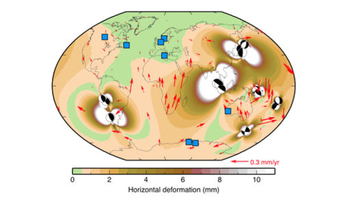
Earthquakes create global-scale GPS errors

Deformation
© Paul Tregoning, Journal of Geophysical ResearchDeformation from earthquakes bigger than magnitude 8.0 since 2000. The blue squares are GPS reference sites, and the red arrows are deformation from big earthquakes.
Twelve years of supersized earthquakes have contaminated GPS sites around the world, a new study finds.

The Global Positioning System is a network of satellites and ground stations that provide location information anywhere on Earth. Except for spots in Australia, western Europe and the eastern tip of Canada, every GPS site on the ground underwent small but important shifts since 2000 because of big earthquakes, according to a study published May 6 in the Journal of Geophysical Research: Solid Earth.

The research confirms that great earthquakes, those bigger than magnitude 8.0, can have far-reaching effects on the Earth's crust. And because GPS is critical for everything from calculating satellite orbits to sea level rise to earthquake hazards, scientists can't ignore these tiny zigs and zags, the researchers conclude.

"We have to find a way to deal with it," said Paul Tregoning, lead study author and a geophysicist at Australia National University in Canberra. "The community needs to work out how to find all the offsets, estimate them accurately and get everyone to agree on how to correct them," he told LiveScience.

Tregoning and his colleagues modeled the sudden jolts in Earth's crust from each of the 15 biggest earthquakes since 2000. They discovered that crust thousands of miles away from the faults had moved horizontally by as much as a tenth of an inch (a few millimeters). The model was checked against a few spots around the planet. On average, the earthquakes deformed the crust by a hundredth of an inch every year (0.4 millimeters a year) - about the width of the lead in a mechanical pencil.

"It's quite amazing to us that we can see this and detect this," Tregoning said.

These tiny effects won't make a difference to the GPS in cars or phones, or the tough little units carried by hikers and mountaineers. But scientists who need precise measurements to calculate sea level rise or satellite orbits should be concerned, Tregoning said.

Bizarro Earth

USGS: Earthquake Magnitude 7.4 - SW of Vaini, Tonga

Tonga Quake_230513
© USGS
Event Time
2013-05-23 17:19:04 UTC
2013-05-23 05:19:04 UTC-12:00 at epicenter

Location
23.025°S 177.109°W depth=171.4km (106.5mi)

Nearby Cities
282km (175mi) SW of Vaini, Tonga
287km (178mi) SW of Nuku'alofa, Tonga
712km (442mi) SE of Suva, Fiji
812km (505mi) SE of Nadi, Fiji
818km (508mi) SSE of Lambasa, Fiji

Technical Details

Bizarro Earth

USGS: Earthquake Magnitude 6.0 - ESE of Petropavlovsk-Kamchatskiy, Russia

Kamchatskiy Quake_210513
© USGS
Event Time
2013-05-21 01:55:08 UTC
2013-05-21 12:55:08 UTC+11:00 at epicenter

Location

52.505°N 160.470°E depth=33.9km (21.1mi)

Nearby Cities
136km (85mi) ESE of Petropavlovsk-Kamchatskiy, Russia
147km (91mi) ESE of Vilyuchinsk, Russia
159km (99mi) ESE of Yelizovo, Russia
988km (614mi) SE of Magadan, Russia
2483km (1543mi) NE of Tokyo, Japan

Technical Details

Cloud Grey

Huge tornado devastates Oklahoma City suburb, kills 37


At least 37 people -- including seven children at an elementary school -- were killed when a storm with a massive tornado struck an area outside Oklahoma City on Monday afternoon, officials said.

Seven children were killed at Plaza Towers Elementary School in Moore, Oklahoma, a police official said. Emergency personnel were scouring the school's rubble Monday evening, video from CNN affiliate KFOR showed. The footage also showed a number of other leveled buildings.

The tornado was estimated to be at least 2 miles wide at one point as it moved through Moore, in the southern part of the Oklahoma City metropolitan area, KFOR reported. Video from CNN affiliates showed a funnel cloud stretching from the sky to the ground, kicking up debris.

Cloud Precipitation

Geological upheaval - April 2013


Bizarro Earth

Shallow 6.5 magnitude earthquake strikes off the coast of Aisen, Chile

Image
The U.S. Geological Survey says a magnitude-6.5 earthquake has struck off the coast of Chile. The quake was recorded at 5:49 a.m. local time (EDT; 0949 GMT) Monday, at a shallow depth of 10 kilometres, some 600 kilometres from the city of Puerto Quellon. No tsunami warning was issued. Chile's naval seismology office says it was not felt on land. U.S. seismologists originally estimated the magnitude at 6.8. Chile is one of the world's most earthquake-prone countries. A magnitude-8.8 quake and the tsunami it unleashed in 2010 killed 551 people and destroyed 220,000 homes. It was so strong it changed time, shortening the Earth's day slightly by changing the planet's rotation. The strongest earthquake ever recorded also happened in Chile, a magnitude-9.5 in 1960. - CTV News

USGS Technical data

Bizarro Earth

Tension mounting on Pacific Plate: Kamchatka rocked by scores of earthquakes

A massive earthquake swarm has occurred in the region of Petropavlovsk-Kamchatskiy, Russia. More than 20 earthquakes have struck the region in the last 22 hours- the strongest of which was a 5.9 magnitude earthquake, which rattled the seafloor at a depth of 16.5 km deep. The latest seismic flare-up along this region reflects growing agitation on one of the planet's largest tectonic plates- the Pacific plate. Increasing seismic volatility along this region of Kamchatka could have serious ramifications for every tectonic plate that comes into contact with the Pacific plate- from the South Pacific to South America. A similar, more intense earthquake swarm occurred along the periphery of the Pacific Plate near the Santa Cruz Islands in February of this year. Is the Pacific plate on the verge of a large-scale change?
Image

Bizarro Earth

USGS: Earthquake Magnitude 6.1 - NE of Namie, Japan

Namie Quake_180513
© USGS
Event Time
2013-05-18 05:48:00 UTC
2013-05-18 14:48:00 UTC+09:00 at epicenter

Location
37.761°N 141.454°E depth=41.5km (25.8mi)

Nearby Cities
50km (31mi) NE of Namie, Japan
61km (38mi) ESE of Watari, Japan
62km (39mi) ESE of Marumori, Japan
63km (39mi) ESE of Kakuda, Japan
278km (173mi) NE of Tokyo, Japan

Technical Details