Earthquakes
S


Network

USGS: M6.0 - 43km ESE of Uyugan, Philippines

Earthquake Philipines
© USGS
Event Time
2013-09-06 11:33:53 UTC
2013-09-06 19:33:53 UTC+08:00 at epicenter

Location
20.189°N 122.314°E depth=178.1km (110.6mi)

Nearby Cities

43km (27mi) ESE of Uyugan, Philippines
214km (133mi) NNE of Aparri, Philippines
217km (135mi) NE of Claveria, Philippines
258km (160mi) SE of Hengchun, Taiwan
634km (394mi) NNE of Manila, Philippines

Technical Details

Bell

More fracking headaches as earthquake evidence grows

Earthquake damaged road
© Martin Luff
It looks like more trouble is looming ahead for communities that host fracking operations. Two new studies have linked fracking-related operations to earthquakes in Texas and Ohio, and a recently settled lawsuit in Arkansas indicates that swarms of tiny earthquakes can damage surface structures. Add earthquakes to a list that already includes water contamination and air pollution risks, and it becomes clear that a more effective regulatory platform is needed to protect existing communities from the impacts of fracking.

The Fracking Explosion

Fracking is short for hydrofracturing, a drilling method that releases oil or gas from shale formations by pumping a chemical brine underground. Somewhat ironically, the method was originally developed by federal researchers to aid the geothermal industry.

As an "unconventional" oil and gas drilling method, fracking was not in widespread use in the US until recent years, and regulatory agencies have been scrambling to play catchup as evidence of water and air impacts piles up.

Bizarro Earth

USGS: M6.0 - 50km W of Sardinal, Costa Rica

6.0 Costa Rica Earthquake
© USGS
Event Time
2013-09-05 12:29:15 UTC
2013-09-05 06:29:15 UTC-06:00 at epicenter

Location

10.586°N 86.106°W depth=18.0km (11.2mi)

Nearby Cities
50km (31mi) W of Sardinal, Costa Rica
67km (42mi) WNW of Santa Cruz, Costa Rica
73km (45mi) W of Liberia, Costa Rica
86km (53mi) NW of Nicoya, Costa Rica
171km (106mi) S of Managua, Nicaragua

Technical Details

Bizarro Earth

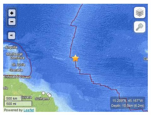
USGS: Earthquake Magnitude 6.0 - Northern Mid-Atlantic Ridge

Mid Atlantic Quake_050913
© USGS
Event Time
2013-09-05 04:01:35 UTC
2013-09-05 01:01:35 UTC-03:00 at epicenter

Location
15.209°N 45.167°W depth=10.0km (6.2mi)

Nearby Cities
1378km (856mi) NNE of Remire-Montjoly, French Guiana
1380km (857mi) NE of Cayenne, French Guiana
1380km (857mi) NE of Kourou, French Guiana
1388km (862mi) NNE of Matoury, French Guiana
1446km (899mi) NE of Saint-Laurent-du-Maroni, French Guiana

Technical Details

Bizarro Earth

USGS: Earthquake Magnitude 6.2 - 88km SW of Atka, Alaska

Atka Quake_040913
© USGS
Event Time
2013-09-04 06:27:05 UTC
2013-09-03 18:27:05 UTC-12:00 at epicenter


Location

51.327°N 174.857°W depth=37.0km (23.0mi)

Nearby Cities
106km (66mi) SSW of Atka, Alaska
1559km (969mi) SSE of Anadyr', Russia
1811km (1125mi) E of Petropavlovsk-Kamchatskiy, Russia
1828km (1136mi) E of Yelizovo, Russia
2641km (1641mi) W of Whitehorse, Canada

Technical Details

Bizarro Earth

USGS: Earthquake Magnitude 6.5 - 77km SSW of Atka, Alaska

Atka Quake_040913
© USGS
Event Time
2013-09-04 02:32:33 UTC
2013-09-03 14:32:33 UTC-12:00 at epicenter

Location
51.592°N 174.760°W depth=39.9km (24.8mi)

Nearby Cities
77km (48mi) SSW of Atka, Alaska
1532km (952mi) SSE of Anadyr', Russia
1809km (1124mi) E of Petropavlovsk-Kamchatskiy, Russia
1826km (1135mi) E of Yelizovo, Russia
2618km (1627mi) W of Whitehorse, Canada

Technical Details

Bizarro Earth

USGS: Earthquake Magnitude 6.5 - Izu Islands, Japan region

Izu Quake_040913
© USGS
Event Time
2013-09-04 00:18:24 UTC
2013-09-04 09:18:24 UTC+09:00 at epicenter

Location
29.986°N 138.811°E depth=404.8km (251.5mi)

Nearby Cities
356km (221mi) SSW of Hachijo-jima, Japan
494km (307mi) SSE of Shingu, Japan
514km (319mi) S of Oyama, Japan
515km (320mi) SSE of Owase, Japan
637km (396mi) S of Tokyo, Japan

Technical Details

Bizarro Earth

USGS: Earthquake Magnitude 6.0 - 191km WSW of Bella Bella, Canada

Bella Bella Quake_030913
© USGS
Event Time
2013-09-03 20:19:06 UTC
2013-09-03 11:19:06 UTC-09:00 at epicenter

Location
51.198°N 130.405°W depth=1.0km (0.6mi)

Nearby Cities
191km (119mi) WSW of Bella Bella, Canada
347km (216mi) S of Prince Rupert, Canada
388km (241mi) WNW of Campbell River, Canada
388km (241mi) SSW of Terrace, Canada
592km (368mi) NW of Victoria, Canada

Technical Details

Bizarro Earth

USGS: Earthquake Magnitude 6.1 - 54km WSW of Panguna, Papua New Guinea

PNG Quake_020913
© USGS
Event Time
2013-09-02 04:30:18 UTC
2013-09-02 15:30:18 UTC+11:00 at epicenter

Location
6.565°S 155.058°E depth=49.4km (30.7mi)

Nearby Cities
54km (34mi) WSW of Panguna, Papua New Guinea
65km (40mi) SW of Arawa, Papua New Guinea
394km (245mi) SE of Kokopo, Papua New Guinea
555km (345mi) ESE of Kimbe, Papua New Guinea
625km (388mi) WNW of Honiara, Solomon Islands

Technical Details

Bizarro Earth

USGS: Earthquake Magnitude 6.5 - Kepulauan Barat Daya, Indonesia

Indon Quake_010913
© USGS
Event Time
2013-09-01 11:52:32 UTC
2013-09-01 20:52:32 UTC+09:00 at epicenter

Location
7.542°S 128.278°E depth=132.1km (82.1mi)

Nearby Cities
318km (198mi) ENE of Dili, East Timor
411km (255mi) ENE of Atambua, Indonesia
425km (264mi) S of Ambon, Indonesia
468km (291mi) ENE of Kefamenanu, Indonesia
318km (198mi) ENE of Dili, East Timor

Technical Details