Earth ChangesS


Magnify

Temperatures of Sea Water Fringing South Pole were Tropical 50 million Years Ago

Earth
© Unknown
The temperature difference between equatorial and polar sea waters was minimal during the extremely warm 'Greenhouse world' 60 to 50 million years ago. This is the main conclusion drawn by a team of scientists from Utrecht University, the Netherlands, the NIOZ Royal Netherlands Institute for Sea Research and the University of California, Santa Cruz. The team of scientists, headed by Peter Bijl, show that circum-Antarctic sea water exceeded 30ºC at that time. The results were published in Nature this week.

The conclusions are based on analyses on sediments retrieved from the ocean floor east of Tasmania. This area bordered to Antarctica during the early Paleogene (60-35 milion years ago). Much global warming research is focused on polar areas, because these are particularly sensitive to climate change.

Previously, scientists from Utrecht University and the Royal NIOZ presented in a suite of Nature and Science articles the manifestation of Greenhouse climates in the Arctic regions, with the invasion of tropical algae and sea surface temperatures of up to 24ºC. Meanwhile, temperatures of waters fringing the Antarctic continent during the Greenhouse climates were a great unknown to climate scientists. The multidisciplinary research, published in Nature, now reached a breakthrough.

Better Earth

Farmed Out: How Will Climate Change Impact World Food Supplies?

Impact
© iStockPhotoBLEAK FUTURE?: A new report estimates that climate change will result in 25 million more malnourished children by 2050.
A new study attempts to estimate the effects of climate change on global agriculture--and outline ways to mitigate its most dire consequences

The people of East Africa once again face a devastating drought this year: Crops wither and fail from Kenya to Ethiopia, livestock drop dead and famine spreads. Although, historically, such droughts are not uncommon in this region, their frequency seems to have increased in recent years, raising prices for staple foods, such as maize.

This scenario may simply be a taste of a world undergoing climate change in the mid - 21st century, according to a new report from the International Food Policy Research Institute (IFPRI), a Washington, D.C. - based organization seeking an end to hunger and poverty through appropriate local, national and international agricultural policies. By IFPRI's estimate, 25 million more children will be malnourished in 2050 due to the impact of climate change on global agriculture.

"Higher temperatures and changes in precipitation result in pressure on yields from important crops in much of the world," says IFPRI agricultural economist Gerald Nelson, an author of the report, Climate Change, Agriculture, and Food Security: Impacts and Costs of Adaptation to 2050. "Biological impacts on crop yields work through the economic system resulting in reduced production, higher crop and meat prices, and a reduction in cereal consumption. This reduction means reduced calorie intake and increased childhood malnutrition."

Bizarro Earth

Another Inconvenient Truth: The World's Growing Population Poses a Malthusian Dilemma

Land
© iStockPhotoMALTHUSIAN DILEMMA: How to feed a human population expected to reach nine billion by 2050 while also grappling with poverty as well as climate change, dead zones, biodiversity loss and other environmental ills?
Solving climate change, the Sixth Great Extinction and population growth... at the same time

By 2050, the world will host nine billion people - and that's if population growth slows in much of the developing world. Today, at least one billion people are chronically malnourished or starving. Simply to maintain that sad state of affairs would require the clearing (read: deforestation) of 900 million additional hectares of land, according to Pedro Sanchez, director of the Tropical Agriculture and Rural Environment Program at The Earth Institute at Columbia University.

The bad news beyond the impacts on people, plants and animals of that kind of deforestation: There isn't that much land available. At most, we might be able to add 100 million hectares to the 4.3 billion already under cultivation worldwide.

"Agriculture is the main driver of most ecological problems on the planet," said economist Jeffrey Sachs, Scientific American columnist and Earth Institute director. "We are literally eating away the other species on the planet."

Sachs made his remarks yesterday at a symposium hosted by the institute on how to improve agriculture to address the mounting challenge of feeding the world while combating climate change and stopping the wholesale loss of biodiversity, among other interrelated issues.

Bulb

Scientist: Carbon Dioxide Doesn't Cause Global Warming

A noted geologist who coauthored the New York Times bestseller Sugar Busters has turned his attention to convincing Congress that carbon dioxide emissions are good for the Earth and don't cause global warming. Leighton Steward is on Capitol Hill this week armed with studies and his book Fire, Ice and Paradise in a bid to show senators working on the energy bill that the carbon dioxide cap-and-trade scheme could actually hurt the environment by reducing CO2 levels.

"I'm trying to kill the whole thing," he says. "We are tilting at windmills." He is meeting with several GOP lawmakers and has plans to meet with some Democrats later this week.

Much of the global warming debate has focused on reducing CO2 emissions because it is thought that the greenhouse gas produced mostly from fossil fuels is warming the planet. But Steward, who once believed CO2 caused global warming, is trying to fight that with a mountain of studies and scientific evidence that suggest CO2 is not the cause for warming. What's more, he says CO2 levels are so low that more, not less, is needed to sustain and expand plant growth.

Bizarro Earth

Deluge in Rain-Soaked Philippines Kills Over 160

Image
© AP Photo/Philippine Coast Guard
Driving rain on the heels of back-to-back storms triggered dozens of landslides across the northern Philippines on Friday, burying more than 160 people, washing away villages and leaving almost an entire province under water.

The latest deluge brought the death toll to nearly 500 from the Philippines' worst flooding in 40 years after storms started pounding the country's north on Sept. 26.

More than 160 people were killed in landslides in Benguet and Mountain Province along the Cordillera mountain range, about 125 miles (200 kilometers) north of Manila, officials said. Residents were jolted awake by the rumbling sound of mudslides and floodwaters tearing apart the saturated soil and washing away homes.

Cloud Lightning

Typhoon Melor kills two in Japan

Typhoon Melor, accompanied by heavy rains, smashed into Japan Thursday, killing at least two people in the latest disaster to strike the Asia-Pacific region.

Melor, packing powerful winds, hit Aichi Prefecture's Chita Peninsula early Thursday, the first such storm to make landfall in Japan in two years, storm forecasters said.

At least 64 people were injured and the storm disrupted transportation in a wide area, the Kyodo news agency reported. The Japan Meteorological Agency said the storm was expected to continue moving across the main island of Honshu and to approach the northern island of Hokkaido early Friday.

One of the two dead was a 54-year-old man hit by a falling tree as he delivered newspapers. A 69-year-old man died when a tree branch fell on him.

Kyodo reported 18 Tokaido Shinkansen bullet-train runs were canceled, and the Tohoku, Joetsu, Yamagata, Akita and Nagano lines were temporarily suspended in some sections. Train service also was disrupted in Tokyo.

Bizarro Earth

7.8 and 7.1 Magnitude Earthquakes Near Vanuatu Spark Tsunami Alert

Image
© AFP/FileSeismograph readings. A huge 7.8-magnitude earthquake near Vanuatu prompted a tsunami warning over large parts of the South Pacific on Thursday, seismologists said.
Wellington, New Zealand - Two powerful earthquakes rocked the South Pacific near the Vanuatu archipelago Thursday morning, the U.S. Geological Survey reported, triggering a regional tsunami alert.

The first quake, with a magnitude of 7.8, struck 183 miles (294 kilometers) northwest of the Vanuatu island of Santo, and 354 miles (596 kilometers) northwest of the capital of Port Vila, at a depth of 21 miles (35 kilometers).

Just 15 minutes later a second quake with a magnitude 7.3 hit at the same depth but 21 miles (35 kilometers) farther north of Santo and Port Vila.

The Pacific Tsunami Warning Center immediately issued a regional tsunami warning for 11 nations and territories, including Vanuatu, the Solomon Islands, Papua New Guinea, Nauru, Fiji and Kiribati. A tsunami watch was in effect as far as Australia and New Zealand.

Bizarro Earth

Vanuatu - Earthquake Magnitude 7.8

Image
© USGS
Date-Time:
Wednesday, October 07, 2009 at 22:03:15 UTC

Thursday, October 08, 2009 at 09:03:15 AM at epicenter

Location:
13.052°S, 166.187°E

Depth:
35 km (21.7 miles) set by location program

Distances:
260 km (160 miles) S of Lata, Santa Cruz Islands, Solomon Isl.

295 km (180 miles) NNW of Luganville, Espiritu Santo, Vanuatu

785 km (490 miles) ESE of HONIARA, Guadalcanal, Solomon Islands

2100 km (1310 miles) NE of BRISBANE, Queensland, Australia

Bizarro Earth

US: Grim forecast warns of mudslides in Los Angeles burn areas

Image
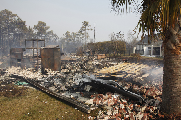
© Francine Orr / Los Angeles Times / September 16, 2009Soil, rocks and branches like these in the fire-scarred Angeles National Forest could be washed far into foothill communities by winter rains, according to the U.S. Geological Survey.
If enough rain falls, some flows could contain enough debris to cover a football field with about 60 feet of mud and rock, and could reach far into communities along the San Gabriel Mountains.

The U.S. Geological Survey on Tuesday issued a grim forecast for foothill communities hit by the Station fire, saying major mudslides are highly likely during the winter rain season.

Scientists identified Pacoima Canyon, Big Tujunga Canyon, the Arroyo Seco, the West Fork of the San Gabriel River and Devils Canyon as being at particular risk. In those areas, the report said there was an 80% likelihood of flows. Under certain conditions, some flows could contain up to 100,000 cubic yards of debris -- enough to cover a football field with mud and rock about 60 feet deep.

Under the worst-case scenario, in which there would be 12 hours of gentle, sustained rain, the report said thick flows of soil, rocks and vegetation could stream downhill into neighborhoods as far south as Foothill Boulevard in such communities as La Cañada Flintridge and La Crescenta.

Cloud Lightning

Indian floods leave 250 dead

Indian floods
© EPAMore than a million people in Andhra Pradesh have sought shelter in 100 relief camps
Floods in southern India have left 250 people dead and displaced millions more.

The floods in Andhra Pradesh and Karnataka states, described as the worst in decades, have resulted in losses of homes, farms and infrastructure worth over 220 billion rupees (£2.9 billion), authorities said.

In Karnataka, the worst-hit of the two states, the death toll has risen to 194 and more than 150,000 were staying in hundreds of state-run relief camps, R.V. Jagdish, a government spokesman said. Hundreds of thousands more had sought shelter in the homes of friends and relatives.