Earth ChangesS

Bizarro Earth

Scars linger from killer Montana earthquake of '59

Image
© AP Photo/Matthew BrownIn this Aug. 13, 2009 photo, Wyatt Carpenter, 19, of Los Angeles, looks at the scar left by a rockslide triggered by the Hebgen Lake Earthquake on Aug. 17, 1959. 28 people died in the disaster, including 19 campers whose bodies are still buried in the rockslide debris.
Gallatin National Forest - Just before midnight under the moon's gray light, the world tilted and tore off a Montana mountainside. Sliding rock buried 19 campers alive, their bodies never found, and 80 million tons of rock and trees tumbled into Madison River Canyon, leaving rubble piled more than 200 feet deep.

The Aug. 17, 1959 earthquake that caused the slide in southwestern Montana remains the largest ever recorded in the Rocky Mountains.

Five more campers drowned when displaced air whooshed down the canyon and swept them into the Madison River. Survivors reported the wind generated by the slide was so strong it ripped off their clothes.

Ten miles away, 15-year-old Martin Stryker was shaken awake in his tent. Woozy with vertigo, he told his two younger brothers to stay put and then went outside. The first thing he saw was a tree fallen on the family's car.

Bizarro Earth

Earthquake Magnitude 6.8 strikes off Japan

A magnitude-6.8 earthquake hit off Japan's southern coast Monday, prompting the Meteorological Agency to issue a tsunami warning.

The quake struck off the coast of Ishigaki island, near Japan's southern island of Okinawa, around 1,000 miles (1,600 kilometers) south of Tokyo. It struck at a depth of about six miles (10 kilometers), the agency said.

Naoto Ohtake, a police official on Ishigaki, said there were no immediate reports of damage or casualties on the island, a popular resort destination with a population of 40,000.

"Nothing fell off during the quake. Electricity, water and gas are all working," Ohtake said.

Cloud Lightning

1,000 still stranded as Taiwan storm aid arrives

Image
© AP PhotoFamily members of the deceased come to the major landslide village of Shiao Lin and call their late family's spirit to rest in peace following Typhoon Morakot hit the area Sunday, Aug. 16, 2009, in Kaohsiung County, southern Taiwan. The first shipments of foreign aid arrived Sunday as Taiwan struggled to reach more than 4,000 people still stranded a week after its deadliest typhoon in half a century.
The first shipments of foreign aid arrived Sunday as Taiwan struggled to reach more than 1,000 people still stranded a week after its deadliest typhoon in half a century.

As plastic sheeting for makeshift housing arrived from the U.S. and water purification tablets came from Australia, taxi drivers in the capital, Taipei, pitched in, driving rice and instant noodles to the island's hard-hit rural south.

President Ma Ying-jeou, who says the death toll from Morakot is likely to exceed 500, offered another apology for his government's response to the disaster after families said more lives could have been saved.

"Sorry we were late," he told people in Pingtung County. "As the president, I will take full responsibility in getting the remaining work done well."

The head of Taiwan's relief operation, Mao Chi-kuo, denied mounting criticism that authorities had failed to evacuate villagers soon enough, blaming the record rainfall instead.

Cloud Lightning

Tropical Storm Claudette threatens Florida Panhandle

Image
© APUpdates as of 5 p.m. EDT; graphic shows the locations and projected paths of Tropical Storms Ana, Bill and Claudette
Pensacola Beach - Brewing in the Gulf of Mexico, Tropical Storm Claudette was bringing heavy rain to the Florida Panhandle Sunday, likely becoming the first tropical storm to strike the U.S. mainland this year.

Claudette had winds of at least 50 mph, but was not expected to cause significant flooding or wind damage. Lurking more ominously was Tropical Storm Bill, which was quickly turning into a powerful storm over warm waters in the open Atlantic with sustained winds of 65 mph. Ana, a tropical storm that had also been churning in the Atlantic, had weakened to a depression.

Skies clouded and bands of intermittent heavy rain moved on shore ahead of the storm, but the Panhandle was largely calm.

Condominiums on Pensacola Beach warned residents to bring balcony furniture indoors with winds anticipated to strengthen throughout the evening. A trickle of cars and SUVs with surfboards on top headed east along the Panhandle as surfers hoped to catch waves whipped up by Claudette.

Info

Dry winds, heat fan wildfires across California

Image
© AP Photo/Noah BergerA firefighter battles the Lockheed Fire as it threatens to jump a road in unincorporated Santa Cruz County, Calif., on Friday, Aug. 14, 2009.
Santa Cruz - Hot, dry winds and high temperatures fanned wildfires across California Sunday, pushing firefighters into rugged terrain to contain the flames and guard against new blazes.

"Things are so dry out there that it doesn't take much for a spark or an ember to quickly develop into a wildfire," said CalFire spokesman Daniel Berlant.

A fire near the Santa Cruz mountain communities of Swanton and Bonny Doon was about 50 percent contained Sunday, after burning 10 square miles since Wednesday and leading to mandatory evacuations of about 2,400 residents. The blaze threatened more than 250 homes and had damaged two outbuildings. More crews were arriving to fight the flames, totaling 2,165 firefighters on Sunday.

California Gov. Arnold Schwarzenegger said Santa Cruz's Lockheed Fire was among 11 burning in the state. A state of emergency was declared in the county, while other blazes forced evacuations and knocked out power in other parts of the state.

Bizarro Earth

Earthquake Magnitude 6.7 - Kepulauan Mentawai, Indonesia

Image
© US Geological Survey
Date-Time:
Sunday, August 16, 2009 at 07:38:25 UTC

Sunday, August 16, 2009 at 02:38:25 PM at epicenter

Location:
1.397ยฐS, 99.473ยฐE

Depth:
44.8 km (27.8 miles)

Region:
Kepulauan Mentawai, Indonesia

Distances:
110 km (70 miles) WSW of Padang, Sumatra, Indonesia

305 km (190 miles) SW of Pekanbaru, Sumatra, Indonesia

560 km (345 miles) SSW of KUALA LUMPUR, Malaysia

960 km (600 miles) WNW of JAKARTA, Java, Indonesia

Footprints

More Steig Disrespect: Common Decency Goes a Long Way

Here is another tone-deaf incident involving the activist wing of the climate science community that has the effect of making the entire enterprise look corrupt. The short story is that a professor from Ohio State found an error in a paper on Antarctic temperature trends in Nature. He published his analysis of the error on the blog Climate Audit and sent a gracious note to the authors letting them know of his discovery.

What did the authors do? They turned around and submitted the correction to Nature as their own work, and then had it published under their own names without so much as an acknowledgment to the Ohio State professor who actually did the work and made the discovery of the error. In academia this sort of behavior is called plagiarism, pure and simple.

Extinguisher

The climate science credit crunch

Climate Credit Crunch
© unknown

Steve McIntyre at Climate Audit has a very interesting discussion on the giving of credit.

Update: Roger Pielke Jr. blogs on this in rather frank terms:
The short story is that a professor from Ohio State found an error in a paper on Antarctic temperature trends in Nature. He published his analysis of the error on the blog Climate Audit and sent a gracious note to the authors letting them know of his discovery.

What did the authors do? They turned around and submitted the correction to Nature as their own work, and then had it published under their own names without so much as an acknowledgment to the Ohio State professor who actually did the work and made the discovery of the error.

Control Panel

Changing Perilous Assumptions to Suit the Analysis

In 2007 Michael Mann and colleagues published a paper (PDF) critical of work suggesting an undercount in storms from historical records, claiming that it was "perilous" to assume that there is a "fixed" relationship between landfalling and total hurricanes in the Atlantic basin:
Of course, estimation of undercount based on the assumption of a fixed relationship between total TC counts and the number of landfalling storms is perilous. Such an approach assumes, in particular, that the large-scale atmospheric steering which determines the trajectories of TCs once they've formed is constant, when there is in fact strong evidence that it is highly variable over time . . .
Now Mann and another set of colleagues (PDF) make what appears to be the exact opposite assumption in a paper just out in Nature, that landfalls are "in rough proportion" to overall basin activity:
We compared the sediment-based record against the above statistical estimate of basin-wide tropical cyclone activity (Fig. 3), guided by a working assumption that an appropriately weighted composite of regional landfalling hurricane activity varies, at multidecadal and longer timescales, in rough proportion to basin-wide tropical cyclone activity.

Bulb

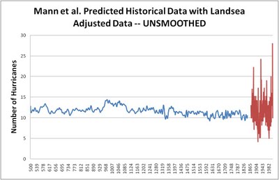
Mann et al. Unsmoothed, Landsea07 Adjusted

UPDATE: I still find this hard to believe, is it possible that Mann has mislabeled his data files such that the smoothed data appears in the annual predictions column in his data file, rather than the raw counts? I find it hard believe that it is otherwise the case.
graph MANN Lansea unsmoothed
© unknown

I was curious how the curve shown in Mann et al. discussed earlier today would look using adjusted data, and thanks to Michael Mann the data is up online allowing a comparison with data adjusted according to work in 2007 by Landsea (i.e., it doesn't include the analysis from Landsea et al. released this week).

I graphed (above) the adjusted data (red curve) along with Mann et al.'s "predicted" historical data (blue curve, based on the Landsea data) both unsmoothed, just to see what it looks like -- using information from these files at Mann's directory: