Earth ChangesS


Cloud Precipitation

A wet and miserable start to Memorial Day weekend


Business Owners On Jersey Shore, Coney Island Curse Mother Nature

Memorial Day weekend it may be, but it might as well be mid-March for New Yorkers who stepped outside Saturday.

The Jersey Shore has technically reopened for the start of the season for the first time since Superstorm Sandy, but not too many people were heading to the shore on Saturday, 1010 WINS' John Montone reported.

Gale force winds were blowing in from the west and chopping up the bay, Montone reported.

Cloud Precipitation

Flooding grips Norway - hundreds evacuated from homes

Flooding has forced hundreds of people to evacuate from their homes in eastern Norway.

The weather has been unsettled across the region over recent weeks, and in just the last couple of days the rain has turned very heavy. Lillehammer reported 64mm of rain on Wednesday, which is more than is expected in the entire month.

Melting snow has also added to the problems.

On 18 and 19 May, the temperatures in Lillehammer soared to 29C. In the surrounding mountains, this sudden rise in temperature caused the snow to suddenly melt.
Image
As the water poured down the mountainside, some of the rivers burst their banks.

One of the worst hit towns was Kvam, which is situated along the Gudbrandsdalslagen River.

Diggers were being used to try and alter the path of the flood water, but work had to be abandoned because the conditions became too hazardous. 250 people had to be evacuated from the town.

Igloo

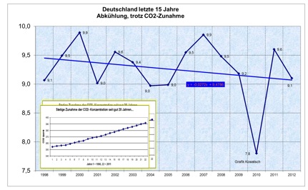
Germany now recording coldest spring in 40 years! "...Climate experts running out of arguments..."!

The recent weather in Germany indicates everything but global warming and widespread drought, which climate experts have been telling us would be the case unless we stopped burning fossil fuels fast.
Germany's Mean Temps
© Josef Kowatsch, data from German Weather ServiceGermany’s mean temperature trend continues falling sharply (1998 – 2012). 2013 so far is well below normal.
Today the online Augsburger Allgemeine reports that the statistics for the 2013 German meteorological spring (March-April-May) have been 95% tabulated and show that this year's German spring is the "coldest in in decades". The Chiemgau24 news site reports that it is the coldest spring in 40 years.

This past weekend, snow even fell in parts of Germany at elevations down to 600 meters.

No reasons are cited as to why the spring 2013 is so cold. The Arctic is covered with ice and so it can't be an exposed Arctic sea disrupting atmospheric patterns.

Cow Skull

Colorado river, High Plains aquifer and entire western half U.S. rapidly drying up

Image

What is life going to look like as our precious water resources become increasingly strained and the western half of the United States becomes bone dry? Scientists tell us that the 20th century was the wettest century in the western half of the country in 1000 years, and now things appear to be reverting to their normal historical patterns. But we have built teeming cities in the desert such as Phoenix and Las Vegas that support millions of people.

Cities all over the Southwest continue to grow even as the Colorado River, Lake Mead and the High Plains Aquifer system run dry. So what are we going to do when there isn't enough water to irrigate our crops or run through our water systems? Already we are seeing some ominous signs that Dust Bowl conditions are starting to return to the region. In the past couple of years we have seen giant dust storms known as "haboobs" roll through Phoenix, and 6 of the 10 worst years for wildfires ever recorded in the United States have all come since the year 2000. In fact, according to the Los Angeles Times, "the average number of fires larger than 1,000 acres in a year has nearly quadrupled in Arizona and Idaho and has doubled in every other Western state" since the 1970s. But scientists are warning that they expect the western United States to become much drier than it is now. What will the western half of the country look like once that happens?

Bizarro Earth

Mount Etna eruptions becoming more violent, and scientists are baffled as to why

Mount Etna is spitting lava more violently than it has in years, and scientists are baffled as to why. Despite being the world's most-studied volcano, the Sicilian mountain is also its most unpredictable. The volcano is raging. Fountains of lava, some taller than the Eiffel Tower, shoot from its mouth every few weeks, flowing in red-hot streams into the surrounding valleys. There have been 13 eruptions since the beginning of February. Mount Etna, 3,329 meters (10,922 feet) high, towers majestically above the Sicilian city of Catania. In June, the United Nations Educational, Scientific and Cultural Organization (UNESCO) will decide whether to list it as a World Heritage Site. Etna is considered the most heavily studied volcano in the world, and it is thoroughly wired with sensors. In addition to lava, Etna spits out vast amounts of data - several gigabytes a day, coming from magnetic field sensors, GPS altimeters and seismic sensors.
Image
Despite this wealth of data, Etna still poses a conundrum to scientists. "The eruptions in recent weeks have been unusually fierce and explosive," reports German volcanologist Boris Behncke, who monitors the mountain together with a few hundred colleagues at Italy's National Institute of Geophysics and Volcanology (INGV). "There have been lava fountain events in the past, but rarely in such rapid succession." Behncke has fallen under Etna's spell. During the day, he maps the lava flows; at night, he hikes along its slopes. His Twitter hash tag is "@etnaboris." The volcano is the first thing he sees when he looks out of his bedroom window every morning. "This time, the range of ash fall is much wider than usual," says Behncke. A layer of black ash covers cars as far as 50 kilometers (31 miles) away.

Bizarro Earth

Another major earthquake on New Madrid is inevitable - geologists say it's only a matter of time

A massive earthquake along the New Madrid fault kills or injures 60,000 people in Tennessee. A quarter of a million people are homeless. The Memphis airport - the country's biggest air terminal for packages - goes off-line. Major oil and gas pipelines across Tennessee rupture, causing shortages in the Northeast. In Missouri, another 15,000 people are hurt or dead. Cities and towns throughout the central U.S. lose power and water for months. Losses stack up to hundreds of billions of dollars. Fortunately, this magnitude 7.7 temblor is not real but rather a scenario imagined by the Mid-America Earthquake Center and the Institute for Crisis, Disaster and Risk Management at George Washington University.
Image
The goal of their 2008 analysis was to plan for a modern recurrence of quakes that happened along the New Madrid fault more than 200 years ago, in 1811 and 1812. No one alive has experienced a major earthquake in the Midwest, yet geologists say it's only a matter of time. That puts a lot of uncertainty on disaster officials. Their earthquake precautions - quake-resistant building codes, for example - have never been reality tested. Some question if enough has been done to strengthen existing buildings, schools and other infrastructure. It is difficult to prepare for a geological catastrophe the public cannot see and has never experienced. "We mostly react to disasters, and it's been extremely rare that we get ahead of things," said Claire Rubin, a disaster response specialist in Arlington, Va. "A lot of hard problems don't get solved. They get moved around and passed along."

Bizarro Earth

'Slow-slip' quake happening off Wellington, New Zealand

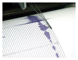
Seismograph
© iStockphotoA stock photo of a reading from a seismograph.
What would be Wellington's biggest earthquake in 150 years is happening right now - not that you'll feel the jolt.

The magnitude-7 equivalent quake, 40km deep, is a "slow-slip" event, when the movement of tectonic plates occurs over hours to months rather than seconds.

GeoNet scientists said even their precision instruments were picking very little up from the 100km area of Levin to the Marlborough Sounds, along the plate boundary.

Almost imperceptibly, the Pacific and Australian plates had been slipping past each other since January and would continue for up to a year, GeoNet scientist Caroline Little said.

"We don't see anything at the surface."

Apart from moving a few centimetres further away from Australia, there would be no noticeable impact from this seismic movement.

But slow-slip quakes had an undetermined relationship with large earthquakes, which were accompanied or even triggered by slow-slip events "and vice versa", she said.
Bizarro Earth

Chile volcano: Evacuation order for Copahue area

Chilean Volcano
© AFPResidents living near Copahue were also evacuated last year after the volcano erupted.
The authorities in Chile have ordered the evacuation of more than 2,000 people living near the Copahue volcano in the south of the country.

They issued a red alert - the highest possible - saying the volcano could erupt imminently.

The evacuation will affect some 460 families living within a 25km (15 miles) radius of Copahue.

The 2,965m (nearly 10,000ft) volcano sits in the Andes cordillera, on the border with Argentina.

"This red alert has been issued after monitoring the activity of the volcano and seeing that it has increased seismic activity," Interior Minister Andrew Chadwick said in a news conference.

"There is a risk that it can start erupting."

The BBC's Gideon Long, in the Chilean capital, Santiago, says that thousands of minor earth tremors have been registered in the area in recent days.

Snowflake

3 feet of snow in upstate New York on Memorial weekend

Image
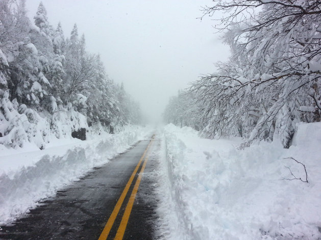
© AP Photo/courtesy of ORDA/WhitefaceAssociated Press/courtesy of ORDA/Whiteface - This photo provided courtesy of ORDA/Whiteface shows Whiteface Mountain Veterans' Memorial Highway after a heavy snowfall Sunday, May 26, 2013. The late-May storm has dropped three feet of snow on the New York ski mountain near the Vermont boarder. Whiteface Mountain spokesman Jon Lundin says 36 inches of white powder have fallen on the nearly 5,000-foot tall mountain in the Adirondacks, forcing the Olympic Regional Development Authority to close Whiteface Veteran’s Memorial Highway on the backside of the mountain.
A Memorial Day weekend storm has dropped three feet of snow on a New York ski mountain near the Vermont boarder.

Whiteface Mountain spokesman Jon Lundin says 36 inches of white powder has blanketed the nearly 5,000-foot tall mountain in the Adirondacks. That has forced the Olympic Regional Development Authority to close Whiteface Veteran's Memorial Highway on the backside of the mountain.

Cloud Grey

Hurricane season fears as warning satellite fails

Image
The failed satellite, launched by Nasa in 2006, was designed to last 10 years.
A satellite designed to track severe weather in the US, has failed on the eve of the 2013 Atlantic hurricane season.

Experts fear it could not have happened at a worse time. The US National Oceanic and Atmospheric Administration (NOAA) said the satellite, which provides coverage for the entire US eastern seaboard, is relied upon to track hurricanes threatening cities along the coast. The NOAA gave a warning that this year's hurricane season - the first since hurricane Sandy devastated the New York and New Jersey shorelines last October - is likely to be "extremely active".

The Atlantic-Caribbean hurricane season begins this week and lasts for six months. The NOAA has predicted as many as 13 to 20 tropical storms could threaten homes, with half of those likely to strengthen.

The NOAA announced that a spare satellite had been activated while attempts are made to fix the failed one, but added there was currently "no estimate on its return to operations".