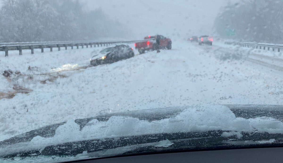
A dramatic weather pattern change marked the first days of 2022 across the Southeast and mid-Atlantic, replacing the 80-degree warmth in some locations with an all-out snowstorm. The onslaught of the first accumulating snow of the season for many left several cities along the East Coast nearly shut down, snarled traffic, left nearly 1 million without power on Monday and has been blamed for at least one fatality, according to officials.
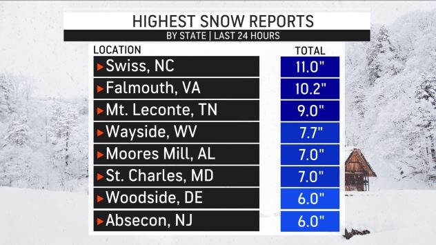
The storm unleashed hefty snow amounts across parts of Tennessee and North Carolina, with accumulations climbing to 9.0 inches in Gatlinburg, Tennessee, and 11.0 inches in Swiss, North Carolina. Even areas as far south as Alabama were hit with a blast of wintry weather, and Moores Mill, Alabama, picked up 7.0 inches of snow.
Blount County Sheriff's Office in Tennessee confirmed with AccuWeather National Reporter Bill Wadell on Monday that a 7-year-old girl was killed after a tree fell on a rental cabin near Townsend, near the Great Smoky Mountains National Park, during the morning hours. Officials are still investigating the cause of the girl's death, but said weather likely played a role. According to the sheriff's office, heavy snow was sticking to the trees, and numerous reports had been called in about snow-covered trees crashing down throughout the day.
The scene across Birmingham, Alabama, on Monday was a complete 180 from the weather the city experienced over the weekend. The city had kicked off New Year's Day with a high temperature of 80 degrees, but just a day later, the temperature had plummeted to 35 degrees and was accompanied by snow and gusty winds Sunday evening into Monday.
Washington, D.C.'s Reagan National Airport reported 7 inches of snow as of 1 p.m. Monday -- the airport's snowiest day since Jan. 13, 2019, when 8.3 inches of snow fell as a part of a storm that totaled 10.3 inches.
Snowfall totals from this one storm were higher in southern locations than cities farther north have measured all season this far. Ashville, North Carolina, is reporting a preliminary 3.6 inches of snow — more snow than New York City (Central Park), Philadelphia and Boston have reported all season combined.
As the storm intensified and marched northward, power outages became a mounting problem across multiple states. Nearly 800,000 customers were without power from Georgia to Tennessee to Maryland, according to PowerOutage.US.
Over 395,000 customers in Virginia alone were without power, followed by more than 150,000 customers without power in North Carolina.
The snow came down at a quick pace across Virginia, and the wintry precipitation was heavy enough to cause thundersnow in parts of the state Monday morning.
Crashes were already mounting before 9 a.m. on Monday as the Virginia State Police responded to 82 traffic crashes by 8 a.m. local time. No injuries were reported, but the public information officer for the state police noted on Twitter that most of the vehicles had been stuck or damaged due to "folks going too fast for conditions." The office urged people to stay off the road and limit travel to only that which was absolutely necessary. By 12:30 p.m., however, the number of crashes had skyrocketed to 559, with another 522 disabled or stuck vehicles reported across the state since after midnight Monday.

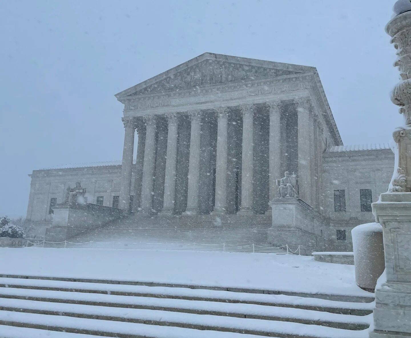
The temperature had climbed into the 60s on the first two days of the new year in the nation's capital before nosediving on Monday. AccuWeather National Reporter Jillian Angeline captured snow creating almost whiteout conditions as it stuck to roads and created slick travel conditions in Washington, D.C.
Asnow emergency declaration was issued for midnight Monday until 7 p.m. Monday by Washington, D.C. Mayor Muriel Bowser. The snow emergency allows snowplows to clear snow emergency routes from curb to curb, according to Bowser. Local and federal offices around the nation's capital will be closed Monday, according to UPI.
The DC health department canceled all COVID-19 testing for Monday due to the snow emergency, and the Washington Metropolitan Area Transit Authority temporarily suspended services due to the weather conditions. The snow also forced the closure of all Smithsonian museums in the D.C. area, including the National Air and Space Museum.
President Joe Biden battled strong winds and heavy snow as he deplaned Air Force One at Joint Base Andrews in Prince George's County, Maryland, shortly before 11 a.m., returning from spending the weekend in Delaware. According to CNN reporter Kaitlan Collins, snowplows were needed to clear the runway in order for the aircraft to land safely. Collins also reported that the presidential motorcade encountered some "difficulty" driving back to the White House amid the storm.
The wintry conditions stretched to the mid-Atlantic coast, including in Atlantic City where accumulating snow and poor visibility were reported early on Monday.
A state of emergency was issued for five southern New Jersey counties -- Atlantic, Burlington, Cape May, Cumberland and Ocean County -- on Sunday night by Gov. Phil Murphy. "Residents should stay off the roads, remain vigilant, and follow all safety protocols," Murphy said on Twitter.


Reader Comments
I'm old and understand many things.
Nothing is what it seems, those with knowledge already know that.
As for being careful, is the tongue as sharp as the sword? Are chat room platforms really there to promote good debate? I could go on.
When I die, I die with a honest heart and mind, evil people don't.