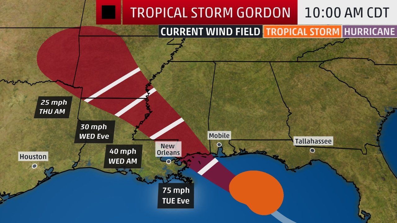
Tropical Storm Gordon is quickly heading toward a landfall tonight along the northern Gulf Coast as a Category 1 hurricane.
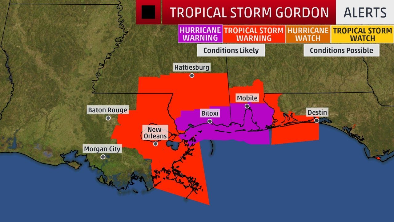
The National Hurricane Center has issued a hurricane warning from the mouth of the Pearl River, Mississippi, to the border between Alabama and Florida.
A hurricane warning means hurricane-force winds (74-plus mph) are expected in the area indicated beginning this evening.
Tropical storm warnings are posted from west of the mouth of the Pearl River, Mississippi, to east of Grand Isle, Louisiana, including Lake Pontchartrain and Lake Maurepas, as well as from the Alabama-Florida border to the Okaloosa-Walton County line in Florida.
A tropical storm warning is typically issued when tropical-storm-force winds (39-plus mph) are expected in 36 hours or less - by Tuesday afternoon, in this case.
Residents along the northern Gulf Coast should rush preparations to completion before conditions begin deteriorating this afternoon.
Current Status, Track and Intensity Forecast
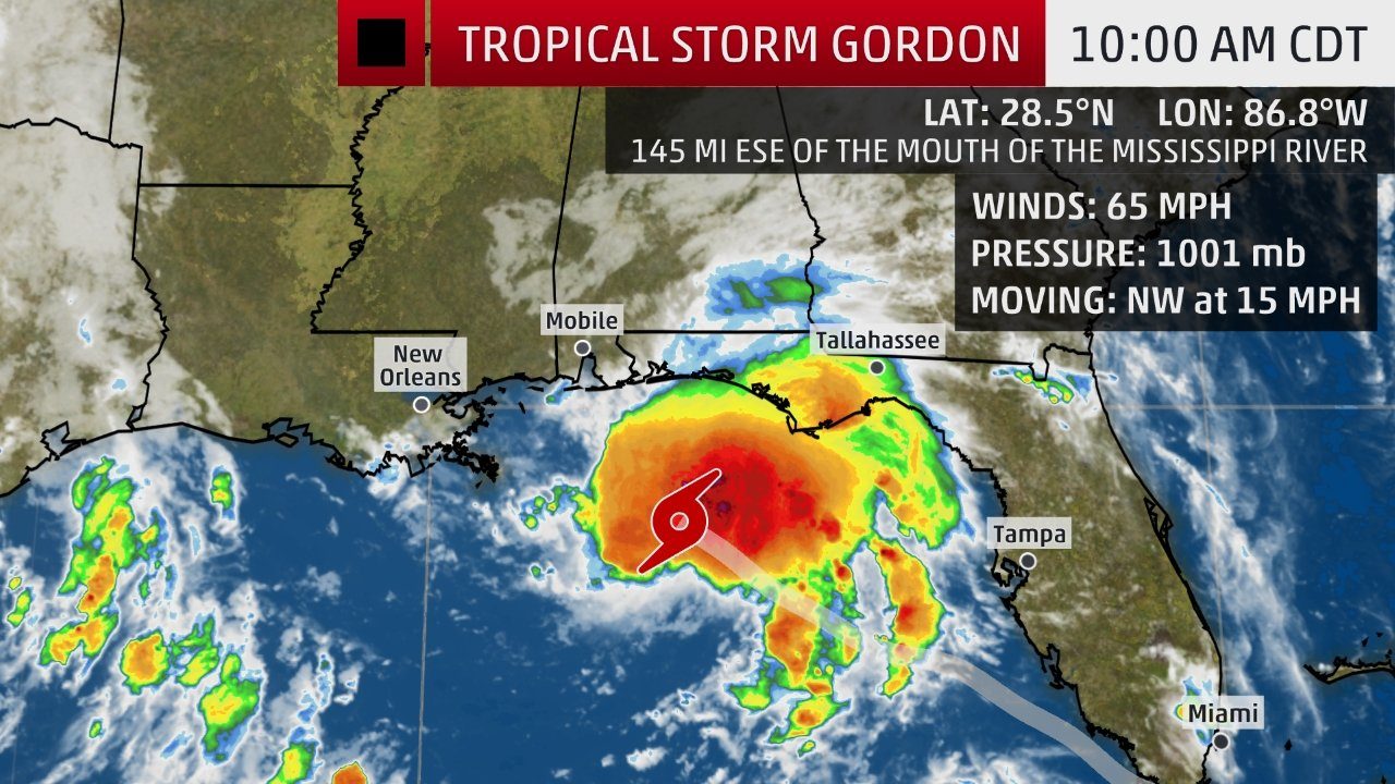
Gordon is currently centered about 145 miles east-southeast of the mouth of the Mississippi River. Gordon's forward speed is relatively fast for a tropical cyclone, generally between 15 to 20 mph.
Current Storm Status
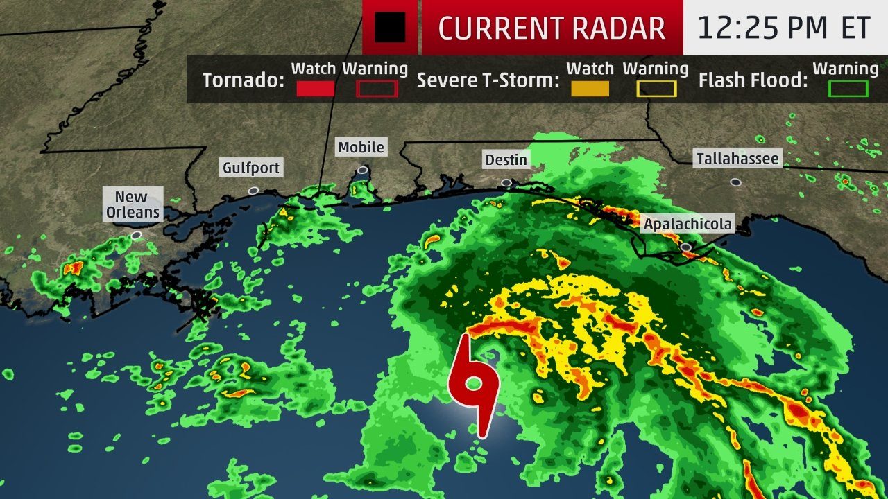
Gordon's heavier rainbands have reached the coast of the western Florida Panhandle, but have cleared the rest of the Florida Peninsula.
Current Radar, Watches and Warnings
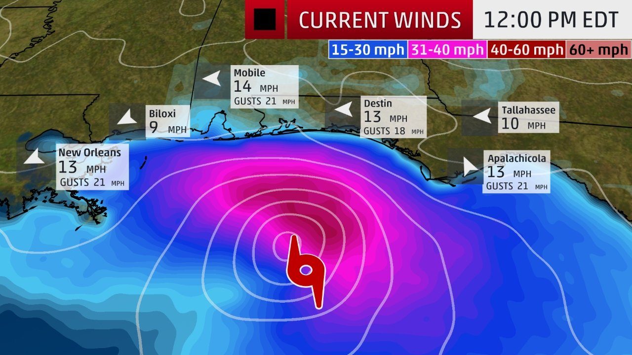
Winds will continue to increase as Gordon continues to approach the northern Gulf Coast.
Current Wind and Wind Gusts
Gordon is forecast to be a Category 1 hurricane near the time it makes landfall on the northern Gulf Coast tonight most likely along the Mississippi Gulf Coast. Given a tropical cyclone's strongest winds are usually are on its eastern side, that's why the NHC issued a hurricane warning for parts of the Mississippi and Alabama coasts.
Projected PathGulf Coast Impacts
Rainfall
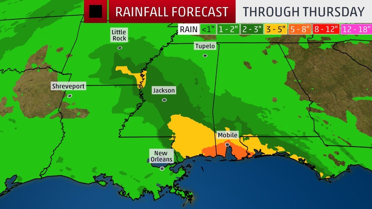
The heaviest rainfall from Gordon is expected to occur generally along or to the east of its track from the northern Gulf Coast to parts of the Arkansas through Thursday. Localized totals of up to 12 inches are possible in some areas.
Rainfall Outlook
Local flash flooding and some river flooding is a good bet in this region, spreading from south to north late Tuesday into Thursday, including the Mobile, Alabama, and Jackson, Mississippi, metro areas.
Flash flood watches have been posted by the National Weather Service for parts of southeastern Louisiana, southern and central Mississippi, far southeastern Arkansas, southwestern Alabama and the western Florida panhandle.
Separate flash flood watches are in effect in southeastern Texas due to heavy rain from another weather system affecting that region into Tuesday morning.
That system produced street flooding in downtown Galveston, Texas, Monday morning.
Storm Surge, Rip Currents and High Surf
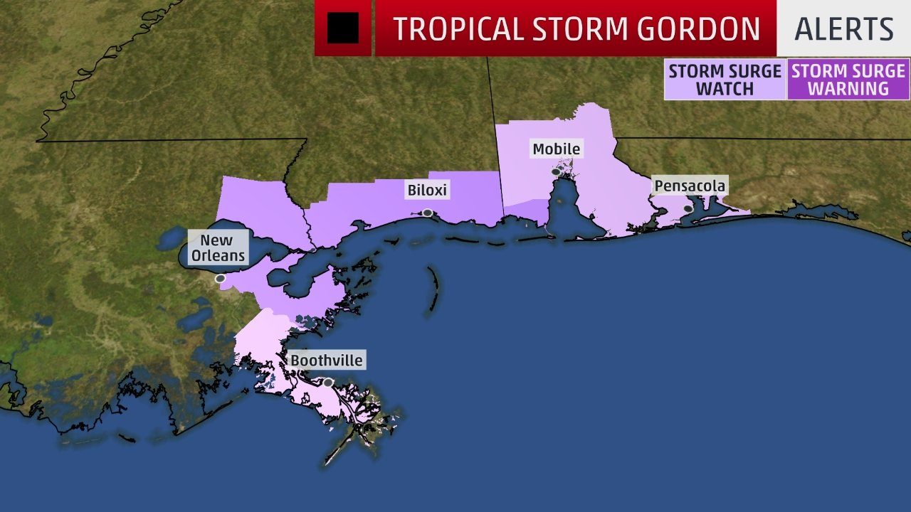
A storm surge warning has been issued from Shell Beach, Louisiana, to Dauphin Island, Alabama. This means in the hours prior to and after landfall, parts of this coastline will see a dangerous, life-threatening storm-surge inundation.
A storm surge watch continues from west of Shell Beach, Louisiana, to the mouth of the Mississippi River and from east of Dauphin Island, Alabama, to Navarre, Florida.
Storm Surge Watches and Warnings
The deepest water will occur along the immediate coast near and to the east of the landfall location, where the surge will be accompanied by large waves, according to the National Hurricane Center.
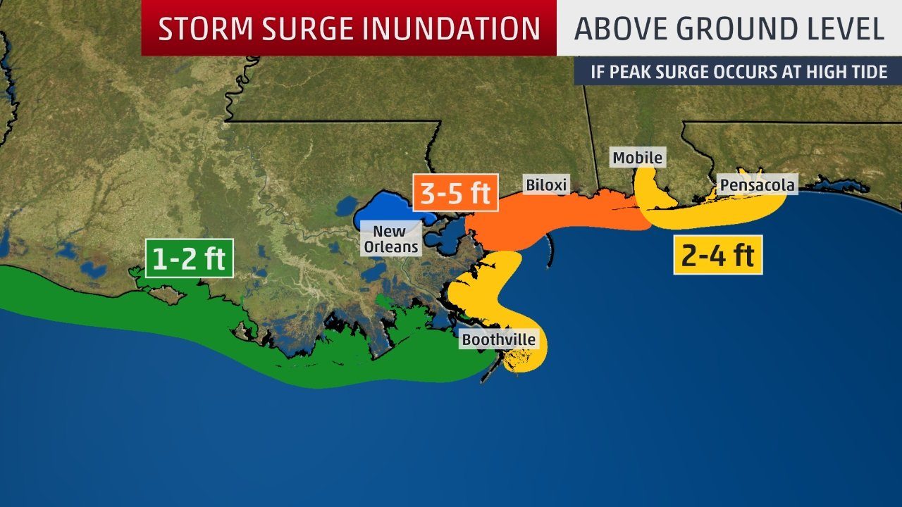
The NHC said water could reach the following heights above ground somewhere in the indicated areas if the peak surge occurs at the time of high tide:
- Shell Beach, Louisiana, to Dauphin Island, Alabama: 3 to 5 feet
- Navarre, Florida, to the Dauphin Island, Alabama, including Mobile Bay: 2 to 4 feet
- Shell Beach, Louisiana, to the mouth of Mississippi River: 2 to 4 feet
- Mouth of the Mississippi River to the Louisiana-Texas border: 1 to 2 feet
Storm-Surge Inundation Forecast
Here are the times of low and high tides along the northern Gulf Coast. There is an evening low tide in the storm surge warning area, followed by a high tide just after 7 a.m. Wednesday. The peak surge should arrive between the times of low and high tides.
- Pensacola, Florida: low tide at 5:29 p.m. Tue; high tide at 7:18 a.m. Wed
- Waveland, Mississippi: low tide at 6:44 p.m. Tue; high tide at 7:21 a.m. Wed
- Shell Beach, Louisiana (south end of Lake Borgne): low tide at 9:42 p.m. Tue; high tide at 10:00 a.m. Wed
Seas are expected to build to 6 to 10 feet by Tuesday, according to the National Weather Service in Mobile, Alabama.
Wind
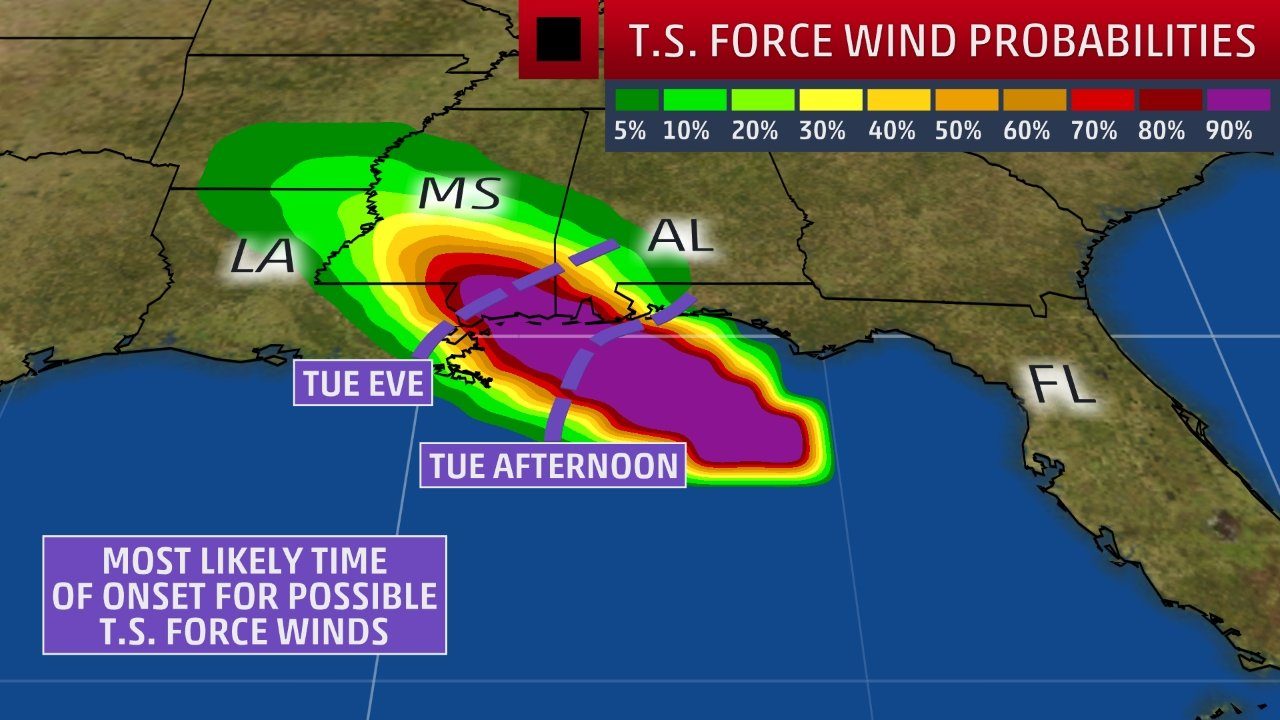
By Tuesday afternoon, tropical-storm-force winds are expected to arrive on the northern Gulf Coast in the tropical storm warning area. Hurricane-force winds are expected in the hurricane warning area by Tuesday evening.
Tropical-Storm-Force Wind Probabilities
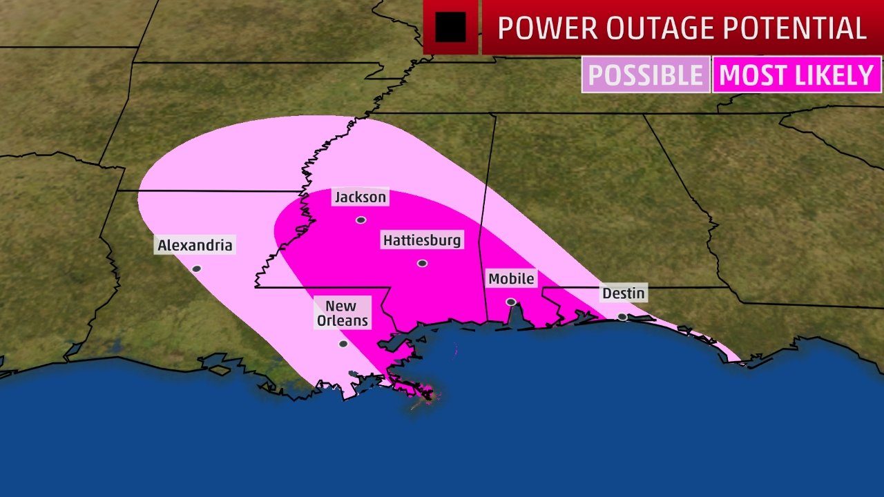
Downed trees and power outages are expected where the tropical storm and hurricane warnings are posted along the northern Gulf Coast.
This is expected no matter whether Gordon is a strong tropical storm or a Category 1 hurricane at landfall. Storm Recap
Advisories were initiated on "Potential Tropical Cyclone Seven" on September 2, a type of advisory NHC uses to issue watches and warnings with more lead time on tropical disturbances expected to eventually develop into tropical cyclones.
In this case, tropical storm watches were first issued for the northern Gulf Coast a full two days ahead of the arrival of tropical storm-force winds.
On Labor Day morning, Tropical Storm Gordon formed near Florida's Upper Keys, based on surface wind observations and Doppler radar data from south Florida.
Heavy rain pounded parts of South Florida, triggering flash flooding in parts of Miami-Dade County, including Homestead and areas near Miami International Airport.
The center of Gordon even passed near Marco Island on Labor Day, which took a direct hit from Irma almost one year ago.
An elevated weather station near Key Biscayne, Florida, measured a 63-mph wind gust Monday morning while a 54-mph gust was clocked at an elevated station near Miami Beach. Sustained winds of 45 mph with a gust to 54 mph were observed Monday morning at an elevated WeatherFlow station near Dania Beach, Florida.
Closer to the ground, a wind gust to 51 mph was reported at Miami's Opa Locka Executive Airport on Monday morning.


Reader Comments
to our Newsletter