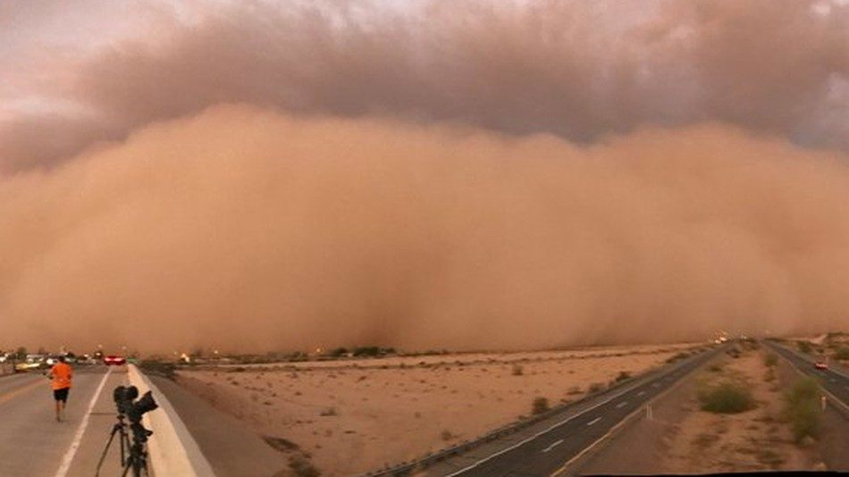
© COURTESY OF MIKE OLBINSKIA fast moving haboob approaches storm chasers in Arizona.
Nothing says "Armageddon" like a mile-high wall of dust racing to swallow you at highway speeds. Commuters on Arizona Interstates 17 and 8 ran into exactly that shortly after 5 p.m. Monday. The culprit was a towering dust storm, along the leading edge of a vigorous thunderstorm complex, known as a haboob.
Arizonans not only dealt with dust but also hurricane-force wind gusts, hail and torrential rain."It was one of those days where we had just about everything," said Brandon Wright, a meteorologist and weather producer at the Weather Channel in Atlanta. "There was hail, wind, flooding and blowing dust. That's about as severe as it gets out there."
Shortly after 4 p.m., monsoonal storms fired along the Mogollon Rim in the Tonto National Forest of Central Arizona. The line raced west, snarling traffic in the Phoenix metro just in time for the afternoon commute. As cool outflow surged ahead of the encroaching storms, strong winds kicked up a curtain of dust high into the sky. Before long, severe thunderstorm warnings were hoisted as the city was plunged into a menacing mass of rain, lightning and burnt-red soil.
Penny-size hail fell in Apache Junction beneath a tail-end storm with some rotation. The town of Mesa saw trees 6 inches thick snap and tumble, while streets became streams amid heavy rain and flooding near Phoenix City Hall.
The storms continued their southwestward march, tracking in all, more than 200 miles, toward the town of Yuma before weakening upon crossing the Mexican border. The National Weather Service in Phoenix issued more than a dozen Dust Storm Warnings throughout the afternoon, warning motorists of "near-zero visibilities" and "life-threatening travel." The setting sun reflecting off the amber-colored dust and dirt made for a surreal scene for storm chasers along the highway.
Winds gusted to 80 miles per hour in the town of Florence, Ariz., and topped 70 in the city of Phoenix.
The Copper State is no stranger to haboobs but even by Arizona standards, this one was a biggie.Veteran Arizona-based storm chaser Mike Olbinski
called it one of the "top two haboobs I've ever chased." Reed Timmer, a storm chaser for AccuWeather who has intercepted hundreds of tornadoes,
described it as
"one of the most incredible sights I have ever witnessed."
Haboobs are most common in the late afternoon and evening hours, as the setting sun cuts off thunderstorm updrafts and the moisture contained within storm clouds collapses toward the ground. This sudden downdraft crashes outward in all directions, lifting the sandy soil at the surface and carrying it for miles. The National Weather Service's Doppler radar even detected the cloud of dust well ahead of the line of storms.
Heavy rains even targeted places as far north as Las Vegas. Since 10 p.m. local time Monday night, the city picked up 0.64 inches of rainfall. While that may not seem impressive,
it is more than Sin City has seen total since Jan. 10. The inclement weather delayed or canceled more than 300 flights at McCarran International Airport.
As residents spend Tuesday heading to the carwash and hosing off their mud-caked homes, more storms could be in the offing. Every summer, a seasonal wind shift from the south bathes the Desert Southwest in monsoonal moisture, allowing afternoon boomers to blossom. While most are meager, a few turn beastly, exactly as was the case on Monday night.
Comment: Last November an unseasonably late haboob dust storm hit Phoenix, Arizona. In May powerful 'freak' dust storms killed over 125 people in north India, the highest death toll in decades. Last month an epic dust storm completely engulfed Mars.
See also: Cosmic climate change: Is the cause of all this extreme weather to be found in outer space?