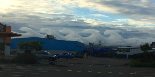
Waves were breaking in the Palmerston North sky this morning in a relatively uncommon phenomenon.
Unsurprisingly the formation is dubbed "breaking wave clouds" but its official title is Kelvin-Helmholtz instability, named after Scots-Irish scientist Lord Kelvin William Thomson and German physician and physicist Hermann von Helmholtz.
MetService meteorologist Tuporo Marsters said the formation was relatively uncommon and there needed to be certain conditions in the atmosphere - and its surrounds - for the breaking waves, or swans, to occur.
Those conditions include moist air in a "stable situation" - no upward movement - and a steady wind source. The photo appeared to be taken early in the morning when temperatures were still cooler.
"It's pretty impressive, alright. It's probably one of the best Kelvin-Helmholtz waves I have ever seen," he said.
In this case, there was a steady easterly flowing, likely funnelling through the Manawatu Gorge, he said. The gorge is also needed to create the waves, as it acts like a barrier.
With the waves, the moist air is rolling over the cloud creating a wave-like formation.
He said the clouds appeared to be quite low and looking at the photo, has formed from right to left.
"The first one is the most perfect and then it breaks up on the third and fourth ... it's low cloud and they've got the prevailing wind which is going across it and it's enough to make these swan, or breaking wave, clouds."
He expected the clouds would have dissipated once temperatures or wind increased.
Palmerston North, like much of the North Island, had warm, muggy conditions overnight. It woke to 18C with a 10 knot, or 19km/h prevailing easterly, before climbing to 24C at lunchtime.
The city hadn't been too wet over the weekend, receiving just 30.8mm of rain between early Friday morning and 10am today.
The rain levels were low compared to other parts of the country. Tauranga has been the wettest, receiving 144mm of rain, followed by Taupo on 107mm, Hamilton 104.6mm and Napier 105.4mm.
The parched areas of Whangarei, Kerikeri, Gisborne and Christchurch also received a bit of rain - 46mm, 62mm, 60.4mm and 8mm, respectively.
Marsters said the rain wasn't expected to go away in a hurry, with most places forecast for showers tomorrow. However, Taranaki would be the wettest with heavy showers and thunderstorms likely.


Comment: