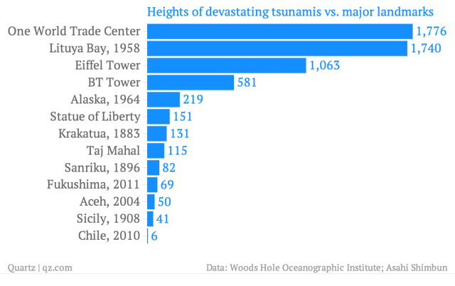
They come taller than that, though. The 1958 tsunami that ripped through Lituya Bay, a sleepy fjord near the Gulf of Alaska, was eight times bigger. And though its causes make it different from the far-traveling waves that slammed Southeast Asia in 2004 or Japan in 2011, the warming of the atmosphere will make both types become more common.
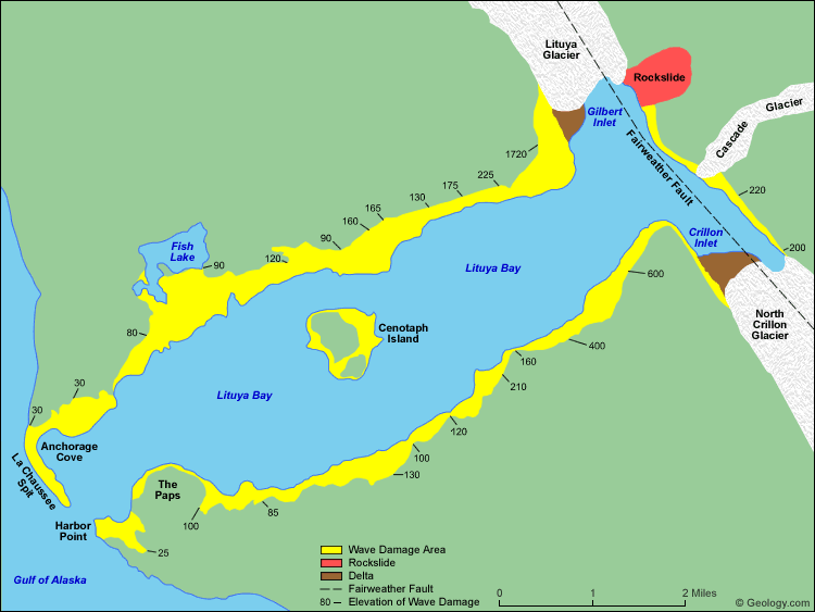
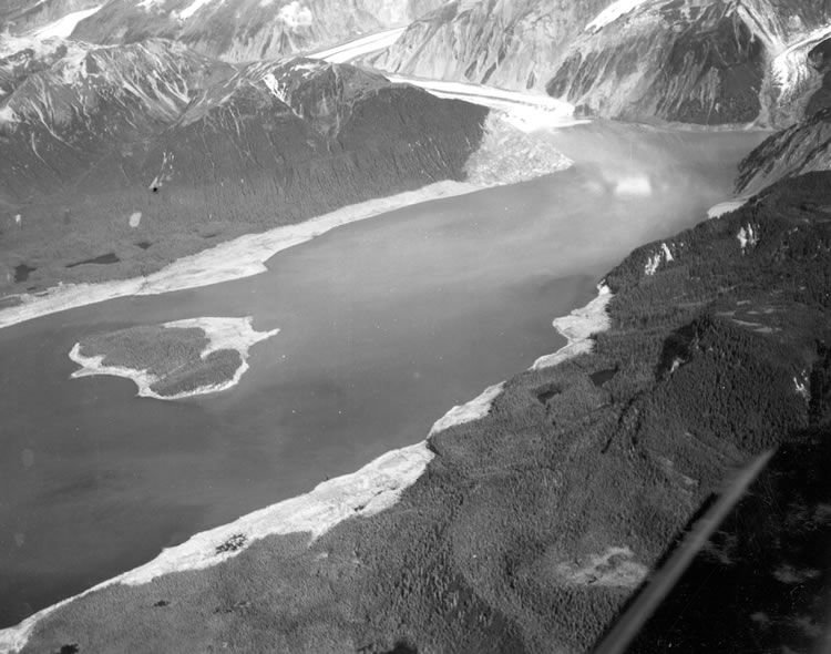
Calamity struck at 10pm on July 9, 1958, when a 8.0-Richter-scale earthquake rammed the Alaskan coast up and northward. That impact shook free between 40 million and 60 million cubic yards (30.6 million and 46 million cubic meters) of rock and ice that rimmed the Lituya basin, dumping it 3,000 feet into the bay below. The 1,720-foot monster that reared up as a result shot through the bay at 100 miles per hour (161 kilometers per hour), as Susan Casey details in her book, The Wave: In Pursuit of the Rogues, Freaks and Giants of the Ocean. Here's how it worked:
Amazingly, four people survived. They were split between one boat that powered directly up the face of the still-building wave, and another that rode it like a surfer about 80 feet above the treetops, until being dumped into the Gulf of Alaska in a hail of uprooted trees.
Flanked by ledges of ice and rock—and close to a fault lively enough to dislodge them and cause avalanches—Lituya Bay's topography is uniquely lethal. Geologists say that a 492-foot wave hit (paywall; pdf, p.155) in 1936, and a 394-footer in 1853. French and Russian explorers met nasty ends there, according to Casey (one christened the middle island "Cenotaph," which means a monument to the dead.) And then there's the story Casey retells of a Tlingit Indian woman who returned from a day of berry-picking to find her entire village swept away, the corpses of her clan strewn among the remaining trees.
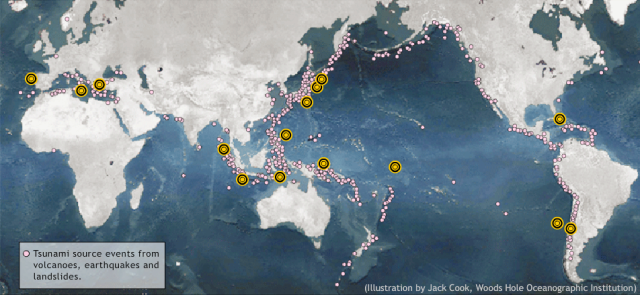
Most tsunamis in historical record start differently, though. Volcanic rumblings and shifting tectonic plates cause undersea earthquakes. When those quakes force enough land upward, they displace huge ripples of water that grow into tsunamis. The Ring of Fire—the volcanic ridge that curls around the Pacific Ocean—is the planet's most seismically active, generating 80% of the world's earthquakes—which is why so many tsunamis slam into Japan and Chile. Landslides, both underwater and above, can create huge waves like Lituya's; earthquakes are usually, though not always, responsible.
Comment: A climate in flux has different meanings to different people depending on who does the telling, some more accurate than others. Anthropogenic modeling and corrupted weather data are not good science. Rather, there are good indicators that the planet, as has happened many times before, is on a global trajectory of accelerated cooling.
To learn why our globe cycles with these weather, atmospheric, geological and celestial events, read Pierre Lescaudron's Earth Changes and the Human Cosmic Connection. A radio interview on Behind the Headlines can be heard here.
In fact, that's what happened at the end of the last ice age, as Casey explains. Though it's impossible to know exactly how that changed the seas, scientists have some clues—for instance, the undersea landslide off Norway about 7,900 years ago. The resulting tsunamis were only 32-64 feet (pdf). Still, those waves swallowed up a big enough chunk of the coast of the Netherlands, Germany, and Denmark that they helped turn Britain into an island.
Comment: Other examples can be found from all over the globe. 180 degrees from Lituya Bay in the Norwegian fjords, these rock slides have cycled and caused great disasters and loss of life. This is further explained in terms of avalanches and landslides by Astor Furseth:
The first overview of all types of avalanche and landslide, including information about more than 3000 avalanche and landslide disasters in Norway over the past 400 years, has been assembled in collaboration with researches at the Norwegian Geological Survey (NGU). Relevant written sources are found from up to 700 years ago, but best documentation is from the 17th. Century, in parish registers and legal examinations pertaining to tax reduction. The oldest written sources are the medieval documents (Diplomatatrium Norvegicum) and the Icelandic annals that mention landslides at Stjørdal ca. 100 and at Støren in 1345, when 500 died. Many legends seem to be based on actual occurrences.On Astor Furseth's blog, he continues with some of these local historic events:
The history of avalanches and landslides partly coincides with that of climatic changes, with avalanches for example around 1680 and landslides in 1743 and 1789. The 19th. Century is characterised by many, fatal avalanches. The 20th. Century on the other hand witnessed a decline in avalanche fatalities. Research shows that the rare giant landslides occur with at frequency of 2 to 5 per century. Thus three major landslides have occurred during the past century; Tafjord 1934, Loen 1905 and 1936, with in all 175 fatalities.
In addition many avalanches and landslides have resulted in more limited damage, often because generations of experience has provided knowledge about local danger. The historical overview is included in a data base of avalanches and landslides held by NGU and may be found at skrednett.no
Rockfall and tsunami in Tafjord 1934Here is simulated video of the Fiord Tsunami:
THE TIMES, Monday April 9, 1934
Norwegian fiord disaster
Flood caused by fall of rock - 40 lives lost
The fall of a huge mass of rock into Korsnaes Fiord, near Aalesund, in Saturday morning caused the waters of the fiord suddenly to rise in great waves, with the result that the villages of Tafjord and Fjoeraa at least 40 lives were lost.
At 3 a. m. on Saturday a great rock, about 1,200ft high and 600ft, broad, loosened in the mountains, fell into the narrow fiord, and immediately afterwards a flood of waves swept over the country for over half a mile inland. In Tafjord village, the inmost in the fiord, the people were awakened by the thunderous crash of rock falling, and very soon afterwards a great wave washed against the shore, to be followed by a second and a third gigantic wave. The waters spread 700 inland, demolishing everything in their way.
Dreadful scenes followed. In the darkness was heard the noise of the roaring waters, the cries of injured and drowning people, and the crash of falling houses. It was nearly half an hour before the waters retired. The fiord was calm again when daylight revealed the desolate scene to the aw-stricken survivors.
Slides and avalanches
Different types of slides and avalanches are common in Norway, mainly due to the rough topography with steep valleys and deep fjords. Avalanches and slides cause loss of life and severe damage to buildings and the transport system. More than 2000 human lives have been lost in avalanches and landslide disasters during the last 150 years.
Quick-clay slides represent a particularly high risk in eastern and central Norway. Snow avalanches affect large parts of western and northern Norway. Large rock avalanches, which can also generate tsunamis, are most common in northern West Norway and in the northern part of Troms in northern Norway.
Snow avalanches
Snow avalanches include several different types from dry powder avalanches to wet-snow avalanches and slushflows. Dry powder avalanches often occur during periods of heavy snowfall and strong winds, in situations where large areas of wind-drifted snow can fail and cause destructive, high-velocity, powder avalanches. Wet-snow avalanches occur during milder periods or in combination with high snowfall rates.
Powder snow avalanches may also generate exceptionally strong winds which can cause significant damages. At some distances from the avalanche itself, trees can be uprooted and houses demolished by the gale-force wind, even on the opposite side of the valley. During recent years, many fatal avalanches have been triggered by people doing downhill-skiing or snow-boarding in steep terrain; and snow-scooters have also caused several destructive avalanches.
Snow avalanches have caused numerous tragedies in Norway, but the most disastrous single event occurred in Sunndalen, central Norway, in February 1868. There, 32 people lost their lives in a snow avalanche at Gråura.
Rockfall and rock avalanches
Rockfalls of small volume are common in Norway and occur on most mountain slopes steeper than 45º, and are often triggered during the spring and autumn by ice melting and extreme rainfall episodes. The triggering mechanisms for large-scale rock avalanches are not fully understood. Large rock avalanches are not very common, but historical documents indicate a frequency of between 2 and 4 events every one hundred years in western Norway. However, such events cause major tragedies when large volumes of rock plunge into a lake or a fjord and generate tsunamis. Such disasters cause a greater loss of life and more material damage than all other types of slides and avalanches in Norway.
One of the largest rock avalanches known occurred in Tafjord approximately 3000 years ago, when more than 100 mill. m3 of rock failed on the mountain Veslejordet. The rock avalanche deposited most of the debris where Tafjord village is situated today. The Tafjord disaster of 1934 occurred in almost the same area. The most severe disasters in historical time occurred at Loen (Sogn og Fjordane) when the mountain side of Ramnefjell failed in 1905 and 1936. These two rock avalanches caused destructive tsunamis with heights of up to 74 metres above the lake level, and 175 people lost their lives.
Quick-clay sides and debris flows
Large parts of lowland areas of Norway, especially in eastern and central Norway, are covered by marine clay. The clay was formed when the sea level was much higher than today, up to as much as 220 m above present-day sea level, shortly after the last ice age. The leaching out of salt water from the clay pores and its replacement by freshwater has strongly increased the sensitivity and the instability of such clays. A decrease in shear strength of the clay and the effect of fluvial erosion have resulted in a large number of quick-clay slides in Norway. Intense rainfall and human activity often triggers the slides. The worst natural disaster known in Norway is the Gauldal slide in central Norway in 1345, which took about 500 lives and destroyed more than 50 farms. The quick-clay slide in Verdal in central Norway in 1893 is also one of the largest, when about 3 km2 of clay failed, and 118 people lost their lives.
Major disasters also occur when glacial tills fail on steep mountain slopes and cause debris flows. Such events often occur during periods of intense rainfall or in combination with snowmelt. A well-known debris-flow event, known as 'Storofsen', occurred in eastern Norway in 1789. In this disaster, large areas of eastern Norway were affected by flooding and debris flows, and this caused severe damage and loss of life.
See also: Massive tsunami devastated northwest Europe 8,150 years ago


All continents have "salt lakes" in them. They are the remains of tsunami. To reach inside a continent, flattening vast areas of land, takes a lot of water. The great Fludde was real.
A small example, of another type, where the minimum height was 200 metres, 600 feet, is the coast of Northeast Australia: Queensland. The wavy lines go 20+ km inland and reach the indicated height. The bay outside Brisbane and northwards islands are composed of heavy mineral sands. Density 4+ whereas beach sand is merely 2.8. These came from the bottom of the sea.
There is an awful lot of bullshit masquerading as science .....
Coal was formed by tsunami sweeping forests into vast heaps, which were then covered in coral sands and silt. Dinosaur fossils are found in similar heaps near coal reserves.