© wunderground.comWinter Storm Dion
Winter Storm Dion, the fourth named winter storm of the 2013-14 season, will result in more snow and ice for some of the same areas impacted by Winter Storm Cleon.
Dion initially will produce snow in the West through Saturday night.
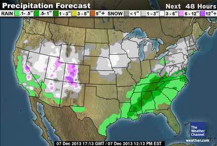
From there, Dion will then spread snow and ice from the Midwest to the Mid-South, Ohio Valley, Middle Atlantic and Northeast Saturday night into Monday.
Here's a look at the forecast through the beginning of next week.
Through Saturday Night: West Snow, Ice Returns to South West Coast Dion pushed into the West Coast Friday into early Saturday.
With an Arctic air mass in place, snow fell at very low elevations in Oregon and California. In fact, accumulating snow was reported all the way to sea level along the coast of Oregon in the town of
Newport. Many cities along the I-5 corridor in western Oregon also saw accumulating snow, including
Eugene (6"),
Corvallis (9") and
Medford (3.2"). Snow was also reported in
Redding, Calif.,
Ukiah, Calif. and just northeast of
Fresno, Calif.
Through early Sunday, Dion will produce snow across Nevada, Utah, southern Idaho, northern and central Arizona, northern New Mexico and Colorado. This will impact travel along the I-40 corridor, including the
Flagstaff, Ariz. area where 4 to 8 inches of snow is expected.
Father north,
Salt Lake City could potentially see 2 to 6 inches of snow.
Farther east, ice will make a return to parts of the Mid-South starting Saturday night.
At this time, it appears some light accumulations of freezing rain and sleet are possible from eastern Arkansas to western/middle Tennessee and Kentucky.
Accumulations are expected to be far less than Cleon, however travel impacts could still be significant. In addition, the weight of the ice could break tree limbs and cause some power outages.
Sunday-Sunday Night: Middle Atlantic, Ohio Valley, Midwest Snow and IceBy Sunday, Dion's impacts will be felt in a large area east of the Rockies.
Washington, D.C.,
Baltimore and
Philadelphia could all see a few inches of snow followed by a transition to sleet and freezing rain on Sunday. In addition to hazardous travel, there could be some power outages and broken tree limbs depending on how much freezing rain accumulates. This wintry mix will eventually changeover to rain Sunday night into Monday.
A wintry mix will also develop in
New York City Sunday night before changing to rain by Monday.
Significant icing is possible to the lee of the Appalachians as cold air gets dammed up against the mountains. The I-81 corridor from Virginia northward through Pennsylvania could see significant impacts. Accumulating ice is also possible as far south as northwest North Carolina. Travel will likely be dangerous and power outages are possible. This includes
Roanoke, Va.,
Hagerstown, Md. and
Greensboro, N.C.In the Midwest, expect light to moderate snow in parts of Kansas, Nebraska, Missouri, Iowa, Minnesota, northern Illinois, Wisconsin and Michigan. Accumulations will be light overall, but travel may still be affected.
Monday: New England Wintry Mess Northeast Forecast MondayBy early Monday, the majority of the energy associated with Dion will be over Canada.
However, it appears there will be a mixture of snow, sleet and freezing rain in parts of New England, upstate New York and northern Pennsylvania. From coastal Southern New England to the Middle Atlantic, the precipitation will have changed to rain.
or does it seem strange that we're naming all our storms these days?