Now we have had a few days to reflect on the terrible events of last week, we can start to piece together some of the facts.
First of all, as it is the thing that really matters above all, fatalities. The good news, if it can be termed that, is that the death toll is likely to be around 2000 to 2500, according to the Philippine President. This is much less than the 10,000 originally feared to have died.
As far as the storm itself was concerned, the official statistics from the Philippine Met Agency, PAGASA, remain the same as those issued at the time. The table below compares these with the original satellite estimates put out by the Joint Typhoon Warning Centre, JTWC, and that were subsequently used by the media around the world to claim that Yolanda was the "strongest storm ever".
| . | PAGASA | JTWC |
| Sustained Wind Speed mph | 147 | 195 |
| Gust mph | 171 | 235 |
http://www.ndrrmc.gov.ph/attachments/article/1124/Update%20SWB%20No.6%20re%20TY%20YOLANDA%205AM.pdf
http://www.webcitation.org/6KyWsFio5
http://www.bbc.co.uk/news/world-asia-24878801
As far as sustained wind speeds are concerned, the PAGASA numbers are based on 10-minute averages, whilst the JTWC are on 1-minute averages, so the latter are always likely to be higher. Is it possible then to draw any conclusions?
According to NOAA NHC hurricane expert, Chris Landsea,
"One complication with the use of the 1 min averaging time for the standard for sustained wind in the Atlantic and Northeast Pacific tropical cyclone basins (where the United States has the official World Meteorological Organization tropical cyclone advisory responsibilities) is that in most of the rest of the world, a 10 min averaging time is utilized for "sustained wind". While one can utilize a simple ratio to convert from peak 10 min wind to peak 1 min wind (roughly 12% higher for the latter), such systematic differences to make interbasin comparison of tropical cyclones around the world problematic. "So on this rule of thumb,adding 12% to the PAGASA number would increase it to 164 mph, on 1-minute averages.
Jeff Masters also mentions that other studies suggest a ratio of 1.14, which would give a figure of 167 mph. He also points out that the Japanese Meteorological Agency estimate 145 mph, using satellite based 10-minute averages, therefore backing up the PAGASA version.
There is still, therefore, a big gap between JTWC and the others. A clue to this difference is given by Masters:
Haiyan's strongest winds occurred on the south shore of Samar Island and the city of Guiuan (population 47,000), where the super typhoon initially made landfall with 1-minute average winds estimated at 195 mph. This estimate came from the Joint Typhoon Warning Center, and was based on satellite measurements. We have no ground level or hurricane hunter measurements to verify this estimate. Typhoon and hurricane maximum wind speed estimates are only valid for over water exposure, and winds over land are typically reduced by about 15%, due to friction. This would put Haiyan's winds at 165 mph over land areas on the south shore of Samar Island.So how does all this compare with earlier hurricanes and is there any justification for the "strongest ever" claims.
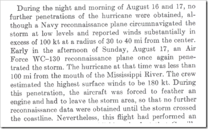
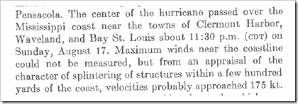
Hurricane Camille in 1969 is generally accepted as the strongest in recent decades. NOAA describe the wind speeds:
The actual maximum sustained winds will never be known, as the hurricane destroyed all the wind-recording instruments in the landfall area. The estimates at the coast are near 200 mph.The "Atlantic Hurricane Season of 1969", published at the time offers more detail:
Note that 180 knots = 207 mph, and 175 knots = 202 mph.
Quite simply Yolanda and Camille cannot be seriously compared with each other.
It is probably also worth taking note of these two statements.
Mr. Paciente [a forecaster with the Philippine government's national weather agency] stated:
Before the typhoon made landfall, some international forecasters were estimating wind speeds at 195 m.p.h., which would have meant the storm would hit with winds among the strongest recorded. But local forecasters later disputed those estimates. "Some of the reports of wind speeds were exaggerated,"Roger Edson, the science and operations officer at the United States National Weather Service in Guam said
The Philippine weather agency measured winds on the eastern edge of the country at about 150 m.p.h., he said, with some tracking stations recording speeds as low as 100 m.p.h.
195 m.p.h. winds would put the storm "off the charts," but he acknowledged that satellite estimates require further study on the ground to determine if they were accurate.Wind Gusts
As well as the discrepancies in sustained wind speed, there is also a big gap in the claimed top gusts. Chris Landsea also has a useful rule of thumb:
Gusts are a few seconds (3-5 s) wind peak. Typically in a hurricane environment, the value of the maximum 3 second gust over a 1 minute period is on the order of 1.3 times (or 30% higher than) than the 1 min sustained wind.So, assuming 164 mph sustained winds, we would expect gusts of 213 mph. Whereas JTWC estimated 235 mph, the figure officially recorded by PAGASA was only 171 mph, which suggests the sustained speeds may have been slightly lower than we have assumed.
Atmospheric Pressure
The atmospheric pressure of Yolanda was 895 hPa. Within just the Western Pacific Basin, there have been 20 storms with lower pressure since these figures began to be reliably collected about 60 years ago. The lowest pressure recorded was 870 hPa, with Typhoon Tip in 1979.
Together with ties, typhoons with Yolanda's atmospheric pressure or less can be expected every couple of years in the Western Pacific. Fortunately the vast majority of these never see land, or do so only after significant weakening.
Storm Surge
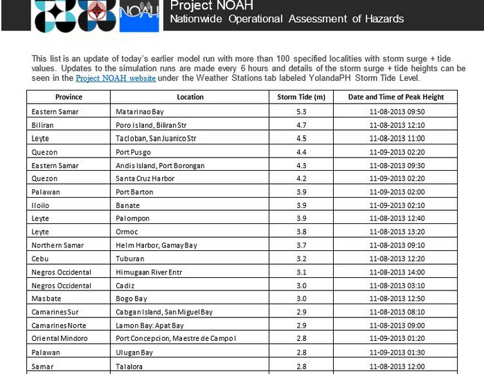
Both CNN and the BBC talk about 40 to 50 feet storm surges , yet the official Philippine body responsible for these matters, NOAH, using JMA models, on 7th November forecast about 5 meters or less for the day after when the storm hit land.
Once again, it appears that some media reports have been wildly overhyped.
http://blog.noah.dost.gov.ph/2013/11/07/list-of-localities-typhoon-yolanda-highest-predicted-storm-surge-and-tide/
Historical Trends
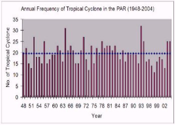
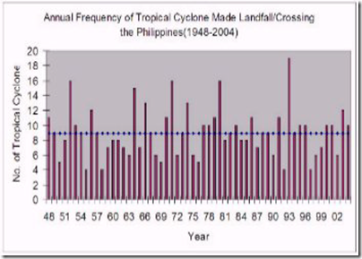
PAGASA show a couple of graphs plotting the number of tropical cyclones from 1948 to 2004. There seems to be little in the way of trends either way.
http://kidlat.pagasa.dost.gov.ph/cab/main.htm
There is a fear that although typhoons are not becoming more frequent, they may be getting more intense. However, given the lack of accurate data from even just a few decades ago, it is difficult to see how any real conclusions can be made.
Summary
It seems reasonable to conclude that Yolanda was a Category 5 storm, i.e. that 1-minute wind speeds were at least 157 mph. However, it was clearly a much less powerful storm than Camille, and arguably many others in recent history.
It is, fortunately, a rare occurrence for storms of Yolanda's strength to cross land, but sometimes it does happen.
The sensationalist and over-hyped reporting of much of the media immediately after the tragedy was, in my view, utterly disgraceful. Perhaps in future, they might care to check the facts first.


Reader Comments
to our Newsletter