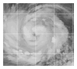
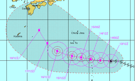
The Joint Typhoon Warning Center (JTWC) reports this morning that Ma-on, about 655 miles east-southeast of Iwo-Jima, has shown "steadily improving organization" over the past six hours, with convection "consolidating around the core" and the emergence of an eye.
The storm's current peak winds are 75 mph, equivalent to category 1 hurricane.
The storm is expected to remain within a tropical airmass with low wind shear and warm sea surface temperatures as it continues west through the northern Philippines Sea. Consequently, significant intensification is forecast over the next 72 hours, with peak winds predicted to reach 125 mph by Saturday morning, equivalent to a category 3 hurricane. JTWC cautions there is no reason to expect signficant weakening until the storm makes landfall.
Exactly where the storm comes ashore is uncertain this far out, but the official JTWC forecast brings Ma-on in the vicinity of southern Japan Monday or Tuesday of next week.
AccuWeather says the storm could bring destructive winds to Japan's southern coasts and 10 to 20 inches of rain.
Stars and Stripes typhoon blogger, Dave Ornauer, writes the storm is likely to affect the U.S. bases in Okinawa:
What winds Okinawa might experience remains up to which way Ma-on moves, but JTWC's latest prognostic reasoning states that the "tremendous scale of the storm will still impact Okinawa" in some manner.Accuweather offers the following prognosis further north from Tokyo to the northeast coast:
Greater Tokyo is unlikely to feel the worst of the storm, no matter its ultimate track. Still, flooding rain and damaging winds could take place in the early to middle parts of the week.After being dealt a natural catastrophe resulting in the record economic damages (not to mention loss of life), Japan could use a break. We'll keep you posted about Ma-on's progress.
Likewise, in northeastern Honshu, at the site of the March tsunami and nuclear disasters, there is the potential for heavy rain, high winds and rough seas next week.


Reader Comments
to our Newsletter