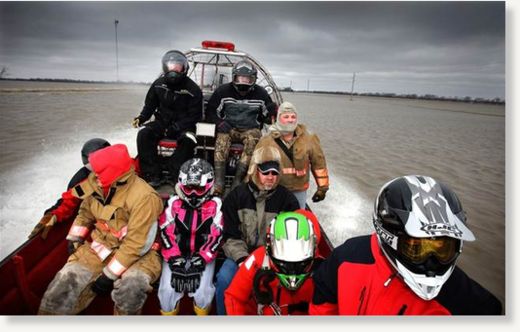
Residents of Oslo, Minnesota, are waiting out massive flooding that has turned their community into a tiny temporary island in the Red River for a third year in a row.
The last road to Oslo closed Tuesday night, leaving a boat ride of at least two miles the only option for residents to reach the banks of the Red River in North Dakota or Minnesota for at least the next week.
"It will be a long haul here," Mayor Scott Kosmatka said in a telephone interview. "By the end of the week I am assuming that people are going to get stir crazy."
Flood fighting efforts have turned to smaller communities along the Red River and its tributaries in North Dakota and Minnesota as the National Weather Service on Wednesday trimmed a foot off the river's projected peak in Grand Forks.
The U.S. Army Corps of Engineers also moved quickly on Wednesday to add to levees on a Red River tributary in the Valley City and Lisbon area west of Fargo for the second time in a week where flows were building beyond prior expectations.
And in northwest North Dakota near Minot, the weather service issued a flash flood watch for residents near a small dam on the Des Lacs River in danger of failing and sending up to an additional three feet of water flowing downstream toward Burlington.
Once past Grand Forks, the Red River widens and flattens to swamp miles of farms and roads in North Dakota and Minnesota during floods. Forecasters expect it to reach up to eight miles across at Oslo within days.
Flooding has closed numerous county and state roads near the Red River and its tributaries in North Dakota and Minnesota over the past two weeks, including parts of Interstate 29 that runs parallel to the Red River in North Dakota.
The flooding was expected to have a major impact on the amount of land North Dakota farmers will be able to plant this spring. A few weeks of warm weather could allow farmers to resume grain and oilseed deliveries.
The river eventually flows through Manitoba, Canada, into Lake Winnipeg. Canadian towns on Wednesday were building ring dikes to prepare for flooding and the provincial government prepared to close Highway 75, the main link to North Dakota.
Winnipeg expects the second-highest crest on record as early as late April.
While they wait for their city 20 miles north of Grand Forks to have road access, Oslo residents plan to build picnic tables for a Red River boat landing used in the summer, Kosmatka said.
Until then there is always the boat, though to some it's a vehicle of last resort.
"Today is not a day I would want to be on the air boat," Kosmatka said. "We have a pretty stiff north wind, it is about 30 degrees. My choice is to sit tight here."


Reader Comments
to our Newsletter