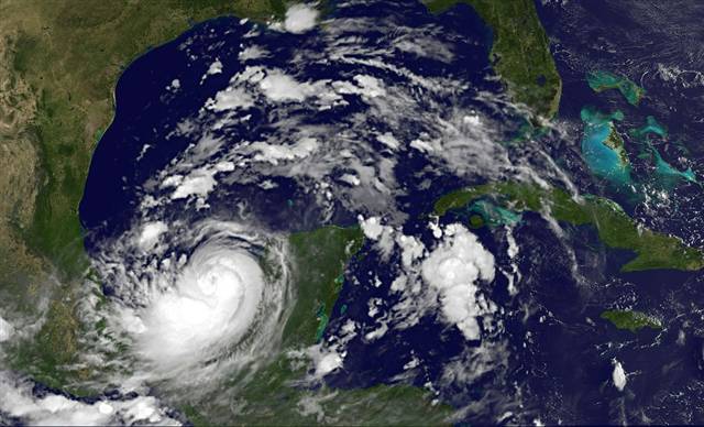
Hundreds of mostly Mayan villagers were evacuated as Karl dumped rain and brought strong winds to the Yucatan, civil protection authorities said.
The storm also knocked out power to tens of thousands of people throughout the mainly rural area. Majahual, home to a large cruise ship port, bore the brunt of the storm as it made landfall but no serious damage was reported.
Mexico's state-run oil giant Pemex has not curtailed any operations but said it would monitor Karl's progress as it approached operations in the Bay of Campeche, where the bulk of Mexico's 2.55 million barrels per day of oil is produced.
The storm was a minor factor for oil traders on Wednesday as prices fell on the repair of a major U.S. pipeline.
Karl lost strength as it moved inland and had maximum sustained winds of 45 mph at 4 p.m. local time (2100 GMT), the U.S. National Hurricane Center said.
By late afternoon it was 95 miles southeast of Campeche on the west coast of the Yucatan peninsula and was expected to weaken to a tropical depression before it entered the Gulf of Mexico.
Karl is then forecast to regain strength and become a hurricane as it crosses the southern Gulf of Mexico before making landfall again on Saturday near the Mexican port of Tuxpan, where Pemex unloads much of the gasoline it imports.
Cancun Spared
Cancun, a top beach destination for U.S. and European tourists, was untouched by the storm, which was also likely to pass far south of U.S. oil and natural gas platforms in the northern part of the Gulf of Mexico.
Two hurricanes, Igor and Julia, also raced across the Atlantic Ocean but posed no immediate threat to land or energy interests along their projected tracks.
Igor, described by the Miami-based hurricane center as "large and powerful," was 1,015 miles southeast of Bermuda with 135 mph winds, making it a dangerous Category 4 storm on the Saffir-Simpson scale.
Julia weakened to a Category 3 storm, with 125 mph winds, 665 miles west-northwest of the Cape Verde Islands and was moving northwest.
The 2010 hurricane season has been more active than average with 11 named storms so far, including four major hurricanes, but damage has been relatively limited as several storms have fizzled out in the Atlantic Ocean.
The rapid early strengthening of many storms this year near the coast of Africa has pushed them on northwest tracks away from vulnerable areas. But with two months left in the hurricane season it is too early to say there will not be another dangerous storm, hurricane expert Rick Knabb with The Weather Channel told Reuters.
"We need to wait until the season is over, before we can make a judgment on the forecasts," Knabb said.


Reader Comments
to our Newsletter