Up to 48,000 homes were without power as blizzards, gale-force winds and torrential rain hit both Scotland and Northern Ireland, knocking down power lines and causing widespread transport havoc.
In the worst-hit part of the province, around 300 people - including children on a school bus - had to be rescued from vehicles trapped in snow overnight on the Glenshane Pass near Londonderry.
While some parts of the UK were below freezing, temperatures in Moscow reached a mild 13c (55f).
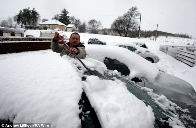
The north of Scotland was worst affected, with temperatures dropping to minus 5C in Cairnwell, near Braemar. Some drivers were forced to dig their cars out from a foot of snow close to Denny in Stirlingshire.
The lorries were stuck for several hours on the M90 as temperatures plummeted overnight across the country.
Around three inches on snow settled on the road overnight, close to Bridge of Earn, making driving conditions difficult.
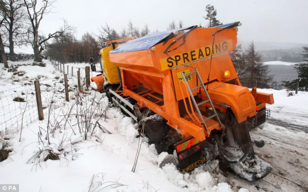
Snow ploughs and gritters were out clearing roads overnight, and one gritter even got stuck in the snow.
There were also delays on the A90 after a lorry jack-knifed in the icy weather.
And there will be more to come as the cold weather pushes south.
Met Office spokesman John Hammond said: 'The worst weather by far, with quite a lot of snow, is in parts of Northern Ireland and also the highlands of Scotland.
'Temperatures are close to freezing and around 20cm (8in) has already fallen in parts of Northern Ireland and a similar amount in parts of Scotland. We could see between 25 and 40cm (10-16in) more overnight.
'There will also be strong to gale force winds. This is going to cause problems not only on the roads becoming impassable but also issues with power supplies.'
The rest of England and Wales can expect rain, he said, adding that the low pressure system causing the snow will begin to pass through today.
Mr Hammond added: 'It is not often you get a situation where you have so much snow and strong winds so late in the season. But it is a very changeable time of the year --there were temperatures of 18c in London last week. There is a real mixed bag to come.'
Although shielded from the worst, southern England is likely to see sleet and frigid temperatures by the end of the week.
Steve Ellison, of Meteogroup, said the cold snap was set to continue for the next two days.
Rain, sleet and snow are set to continue in the Highlands and Cairngorms, with the cold front expected to creep further south until Wednesday.
By Thursday, temperatures are predicted to rise slightly, causing the snow to retreat to the higher ground.
Mr Ellison said: 'Temperatures are not that low for this time of the year at the moment. It is not that far below freezing, but snow is starting on the higher ground.
'The most significant thing is the snowfall to come. Rain, sleet and snow are to continue throughout the day.
'The Highlands, Cairngorms and areas north of the central belt are most affected at the moment, but there will also be snow over the southern uplands.
'It is fairly persistent and during the night, the snow level will start to come further down and it could be quite heavy.
'During Wednesday, it will start to turn to rain and move north.'
The UK has seen mild temperatures for the best part of 10 days.
Julian Mayes, senior forecaster with MeteoGroup, said: 'The month started cold, but the warmer temperatures recently have taken the whole month up to about average for March. The highest reading of the year so far was one of 18C (64F) in Norfolk on March 18.
'But it's not unusual to get a northerly blast in springtime.'
However, it still seems the country really is on course for a scorcher this summer.
The Met Office was pilloried after it wrongly predicted a barbecue summer, but rival forecasters Positive Weather Solutions (PWS) correctly predicted a wash-out.
PWS has 'out-forecast' the Met Office over the last two years with a string of accurate long-term predictions and is confident that Britain will indeed see a barbecue summer in 2010.
It says average temperatures in June, July and August are on course to beat those of 1976, the hottest summer yet when temperatures exceeded 89.6f (32c) for 15 days from late June to early July.
This year a two-week spell at the start of August is expected to be hotter than the UK's highest ever temperature, the 38.5c (101.3f) recorded at Brogdale, near Faversham, Kent, on August 10, 2003.
Senior forecaster Jonathan Powell said: 'There will be stifling temperatures, making it possibly the warmest UK summer on record and placing it at least in the top three warmest summers recorded.'
He predicted 'dry spells with pleasant sunshine' and said the best time to book a holiday would probably be mid-July.
Mr Powell added: 'A very warm summer has been on the cards for some years, and the Met Office believed it was likely to happen last year. But now it is time to get the barbecue out - and people should be able to find a good deal on one after last year's Met Office forecast.'


Reader Comments
to our Newsletter