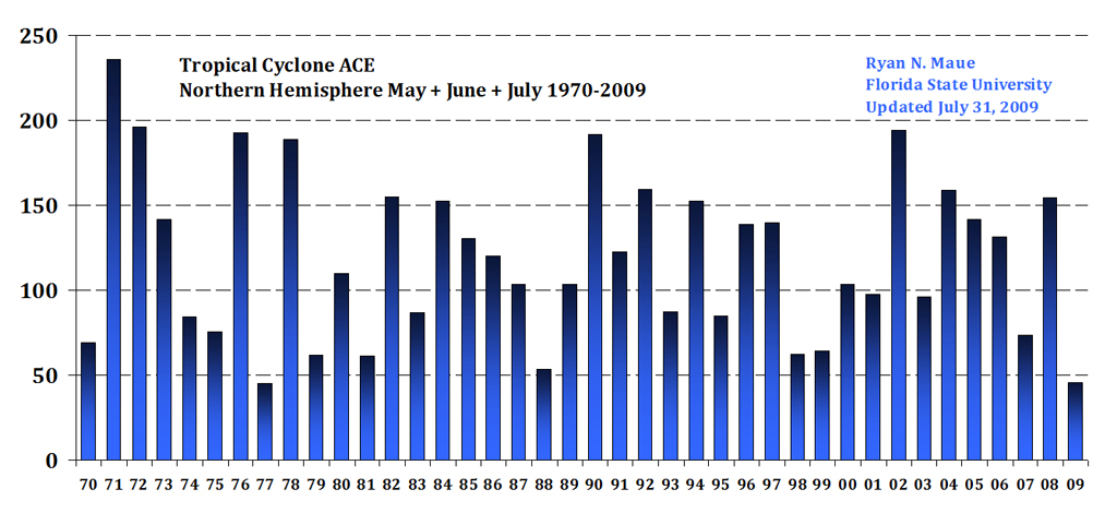
Sorted monthly data: Text File Note where 2009 is in the scheme of things. More here.
NOAA Lowers Hurricane Season Outlook, Cautions Public Not to Let Down Guard
August 6, 2009
Animation of El Niño in Pacific.
El Niño animation (Credit: NOAA)
According to its August Atlantic hurricane season outlook, NOAA now expects a near- to below-normal Atlantic hurricane season, as the calming effects of El Niño continue to develop. But scientists say the season's quiet start does not guarantee quiet times ahead. The season, which began June 1, is entering its historical peak period of August through October, when most storms form.
"While this hurricane season has gotten off to quiet start, it's critical that the American people are prepared in case a hurricane strikes," said Commerce Secretary Gary Locke.
NOAA's Climate Prediction Center, a division of the National Weather Service, now predicts a 50 percent probability of a near-normal season, a 40 percent probability of a below-normal season, and a 10 percent probability of an above-normal season. Forecasters say there is a 70 percent chance of seven to 11 named storms, of which three to six could become hurricanes, including one to two major hurricanes (category 3, 4 or 5).
The main change from the May outlook is an increased probability of a below-normal season, and an expectation of fewer named storms and hurricanes. The May outlook called for nine to 14 named storms, of which four to seven could become hurricanes, including one to three major hurricanes. During an average season, there are 11 named storms with winds of at least 39 mph, of which six become hurricanes with winds of 74 mph or greater and two of those become major hurricanes with winds of 111 mph or higher.
In recent weeks, forecasts for the return of El Niño - warmer than normal waters along the equatorial central and eastern Pacific Ocean - have come to fruition.
"El Niño continues to develop and is already affecting upper-level atmospheric pressure and winds across the global tropics," said Gerry Bell, Ph.D., lead seasonal hurricane forecaster at NOAA's Climate Prediction Center. "El Niño produces stronger upper-level westerly winds over the Caribbean Sea and tropical Atlantic Ocean, which help to reduce hurricane activity by blowing away the tops of growing thunderstorm clouds that would normally lead to tropical storms."
"El Niño may mean fewer storms compared to recent seasons, but it doesn't mean you can let your guard down," said Jack Hayes, Ph.D., director of NOAA's National Weather Service. "History shows that hurricanes can strike during an El Niño." Some examples include Betsy in 1965, Camille in 1969, Bob in 1991, Danny in 1997 and Lili in 2002.
Even though El Niño tends to decrease the number of storms, other climate factors may help to create some storms. As predicted in May, conditions associated with the high-activity era that began in 1995 are in place, and include enhanced rainfall over west Africa and warmer tropical Atlantic Ocean water, which favor storm development.
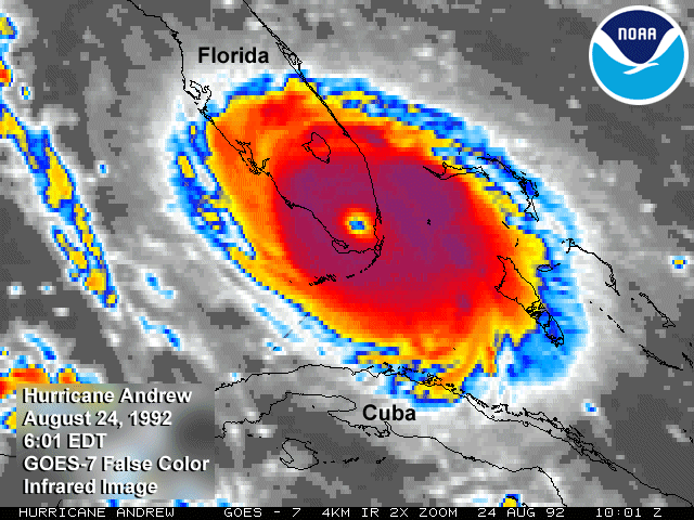
The calm start to this hurricane season is not a reliable indicator of the overall activity for the entire season. The 1992 Atlantic hurricane season, for example, had a below-normal number of named storms and hurricanes. The first storm did not form until late August, when Hurricane Andrew hit southern Florida as a destructive Category 5 storm.

"These outlooks are extremely valuable when determining cycles and trends for the season, however they don't tell us when the next storm will occur or where it may strike," said FEMA administrator Craig Fugate. "It only takes one storm to put a community at risk. That is why we need to take action and prepare ourselves and our families before the next storm hits, including developing a family disaster plan. By taking a few simple steps now we can help ensure that we are better prepared and that our first responders are able to focus on our most vulnerable citizens."
Predicting where and when a storm may hit land depends on the weather conditions in place at the time the storm approaches. Therefore NOAA's seasonal outlook, which spans multiple months, does not include landfall projections. But once a storm appears to be forming, NOAA's National Hurricane Center will issue track and intensity forecasts.
NOAA understands and predicts changes in the Earth's environment, from the depths of the ocean to the surface of the sun, and conserves and manages our coastal and marine resources.


Reader Comments
to our Newsletter