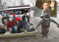
President Obama used recent flooding in Fargo, North Dakota to push his misguided belief in global warming. His comment, "If you look at the flooding that's going on right now in North Dakota and you say to yourself, 'If you see an increase of two degrees, what does that do, in terms of the situation there?'" is speculative and completely wrong.
A two-degree warmer North Dakota would mean less snowfall, therefore less flooding. Spring flooding along the Red River of the north is due to snow melt and the geography of the region. This year the cold winter caused heavy snow in the south basin and all across the northern continental US. Obama's comments do what the focus on global warming does; diverts us from real issues. In this case it is flooding and people living in naturally high-risk areas.
I was a founding member of the International Coalition, a joint project of citizens from Canada and the US living in the flood plain of the Red River.
Failure of the federal governments on both sides of the border to deal with flooding forced creation of this illegal organization. I won't forget riding on the bus to the first meeting at the University of North Dakota and listening to the US federal government bureaucrat in the seat in front of me saying to his assistant, "Which way does this bloody river run anyway?" Later I was the first Chair of the Assiniboine River Management Advisory Board (ARMAB) set up to establish management plans for this river, which is the largest tributary of the Red.

The Red River is the largest and one of very few rivers that start in the US and flow north into Canada. This is not an accident but a result of history. The 49th parallel in western North America was a simple geometric boundary that effectively approximated the divide separating water flowing south into the Gulf of Mexico or north into Hudson Bay. The Hudson's Bay Company was granted land draining into Hudson Bay and that land became part of Canada in 1870 under the British North America Act.
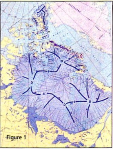
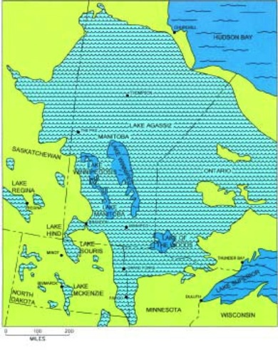
Rivers usually create their own valleys but the Red River runs through lowland formed and occupied by Glacial Lake Agassiz. This lake was created by the meltwater from the Wisconsin ice sheet. Figure 1 shows a reconstruction of the ice at an early stage of lake development, but the middle stage of ice sheet melting. Half of Canada was still under ice as recently as 9,000 years ago, which underscores how quickly climate changes. Lake Agassiz water was confined by high land on the east and west of what is now the Red River valley and ice to the north.
The size of Agassiz is emphasized by Lake Winnipeg (just below the word Manitoba), which is listed as the 13th largest lake in the world by surface area. The Red River follows the boundary between North Dakota and Minnesota flowing north through Winnipeg to drain into Lake Winnipeg. This area was the bottom of Lake Agassiz and as a result is very flat and floods easily and extensively.
When John Palliser surveyed the Red River valley for the British Government in 1857, he said the region was not conducive to farming because of regular spring flooding and slow drainage that meant crops were not planted early enough to allow harvest before fall frosts. Palliser did not anticipate the drainage installed over the next 100 years. Former colleague Professor Bill Carlyle told me the Red River valley in Canada and the US was the largest most densely drained agricultural region in the world.
Despite this there is no evidence that flooding has increased. Massive floods in 1776, 1826, 1950, and 1997 are maximum events of the natural pattern for the region. The 1826 flood was 3 times larger than 1950 and indications are 1776 was even worse. However, the drainage allowed agricultural development and small service settlements, such as Fargo, formed on the extremely fertile lake sediment soils.
Each spring the snow melts first in the southern end of the Red River valley then drains to the river which flows north (Tell the Washington bureaucrat). This creates a problem because the river is still frozen and ice jams frequently block drainage causing more severe flooding. I was involved in two procedures to alleviate the flooding. One was in the 1960s when the Canadian Air Force dropped dynamite to break up ice jams. The other was in establishing flow management on the Assiniboine River to delay or reduce the peak of runoff so it didn't coincide with the peak on the Red. While this eased flooding it didn't address the bigger problem about people living on a flood plain.
It is not a "no risk" world. We can reduce but not eliminate risk. Insurance and government assistance offset but do not eliminate risk. In fact, you can argue they aggravate the problem.
People are effectively compensated for and therefore encouraged to take higher risk. If you live in a flood plain you are going to get flooded and when it occurs frequently someone should consider what is happening. In the US most insurance companies don't cover flood so there is a government program through FEMA.
It is another example of how government policy rewards bad decisions or foolish behavior. It is probable that private insurance did not provide coverage because of frequent claims. The government taking over was not the solution.
Restricting settlement is difficult and potentially undesirable in a democracy, but there should be zoning of risk so people are aware. This way they cannot expect reward from other sensible people's money. Flying search and rescue with the Canadian Air Force we were most often exposed to danger searching for people who had taken foolish and unnecessary risk. Cain's question to God "Am I my brother's keeper?" has come to mean responsibility for other people. I accept the responsibility for my sensible brother, but not my stupid brother.
Sorry President Obama, the Fargo flooding was not due to global warming or even a harbinger of an increased potential. It was a natural event aggravated by a colder winter and more snow. If global warming were to occur, in the Red River case less spring flooding would result. All this diverts from the issues of people living in environmentally dangerous areas and being encouraged to do so by government policies that remove personal responsibility. As Lincoln said, "That government is best which governs the least, because its people discipline themselves." Those who discipline themselves won't need our help as often and we are more likely to give it when unforeseen emergencies occur.


Reader Comments
to our Newsletter