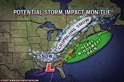
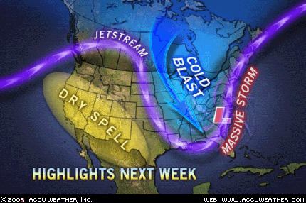
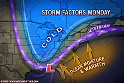
A large, dangerous storm will take shape in the eastern third of the nation early next week, spreading a swath of snow, rain, damaging thunderstorms, flooding and high winds northward from the Gulf of Mexico.AccuWeather.com Meteorologists are confident a major storm will affect the eastern part of the nation Monday (Groundhog Day) into Tuesday of the coming week.
The storm will be large in size, encompassing over 2 million square miles. The system will grab copious amounts of moisture from the Gulf of Mexico with potential to unleash 1 to 2 inches of rain or 1 to 2 feet of snow on some areas. The storm will also intensify as it moves on a nearly south-to-north heading. Warm air south and east of the storm will lead to damaging thunderstorms.
The exact track of the storm will determine the nature of the beast that will pummel an area from the entire, immediate Atlantic coast to nearly as far west as the Mississippi River.
There is a multitude of tracks the storm could take, ranging from just off of the Atlantic coast to a track just to the west of the Appalachians. Over the coming days, computer models will get more in line to one track, and our meteorologists will hone in on the details. For now, we want you to be aware of the consequences of the different tracks the storm could take.
Severe ThunderstormsRegardless of the storm track, damaging thunderstorms will target Florida. Included in the risk of damaging winds, hail and blinding downpours is the threat of tornadoes.
Unstable warm, moist air will be drawn northward from the Gulf of Mexico, making the atmosphere ripe for severe weather in the Sunshine State. If the storm tracks more to the west, damaging thunderstorms would affect a broad area of the southeastern U.S., and perhaps as far north as the mid-Atlantic coast.
FloodingThe amount of flooding will be dependent on the storm track. If the storm travels just off the coast, flooding problems, other that those caused by severe thunderstorms in Florida, would be limited to those caused by strong northeast winds from the Atlantic Ocean.

© AccuWeather
The flooding in this scenario would be from above-normal tides and large waves on the front end. Above-normal tides could also affect inland bays and estuaries with this track.
Any track farther west would mean heavy rain not only near the coast, but inland to a point. The ground is frozen in many areas of the Northeast and, where exposed, the rain will simply run off, somewhat like that of a concrete or paved surface.
The flood threat under this scenario would be the greatest in New England and the mid-Atlantic's interior, where a deep snowpack covers the ground. If the snow is not able to absorb all of the rainfall, the combination of rain and melting snow could severely swell streams and rivers.
In some areas, this scenario could lead to a repeat of the rapid thaw and flooding experienced in January 1996.
High WindsA track along or inland from the coast would lead to strong winds on the front side of the storm. Gale- or storm-force winds would blast the Northeast and mid-Atlantic beaches.
Cold air will combine with blustery winds to significantly chill the entire East as the storm departs Tuesday night and Wednesday. AccuWeather.com RealFeel® temperatures will be much colder than actual thermometer readings.
Wind gusts on the back side of the storm, regardless of the track, will top 40 mph in much of the mid-Atlantic, the Great Lakes and New England.
Heavy Snow

© AccuWeather
A track just off the Northeast coast is the snowiest scenario for the Interstate 95 corridor from the mid-Atlantic through New England. Some areas from the I-95 belt to the spine of the Appalachians would receive a heavy to possibly crippling snowfall with this track. This scenario would also mean little or no snow for much of the Midwest.
A track along or just west of the Appalachian Mountains would lead to heavy snow for portions of the Ohio Valley and eastern Great Lakes, both of which were hit hard by the recent winter storm. These more western tracks would unleash the heavy rain and flooding issues along the coast.
As the storm intensifies upon moving northward, increasing winds in the snowfall areas could lead to near-blizzard conditions with blowing snow, low visibility and substantial drifting.
The cold air in the storm's wake will plunge into the Deep South. Before the storm unleashes its full fury on the Northeast, snow could impact travel as far south as northern parts of Mississippi, Alabama and Georgia.
Why Are We So Concerned?

© AccuWeather
While the Atlantic Coast is a notorious spot for major winter storms, hence the term nor'easter, storms that begin in the Gulf of Mexico are often the biggest of the big. The storm called the "Storm of the Century" or the "Blizzard of '93" began in the Gulf.
While this storm overall has a "warmer look" initially, it could transpire to a colder storm as it moves northward. Additionally, while this storm will likely fall short of the infamous March 1993 event, it could prove to be a memorable storm for many. For some, it may be damaging thunderstorms; for others, a windblown, heavy snowfall.
Fortunately, it appears the storm will be moving fast and is unlikely to bring crippling snow to a large area. Then again, precipitation with the Blizzard of '93 only lasted 12 to 18 hours in most areas.
The worst conditions in the Southeast will be Monday into Monday night, while the worst conditions in the Northeast will be Monday night into Tuesday.
Residents in the eastern third of the nation should continue to check back with AccuWeather.com as the exact track of the "Groundhogzilla" storm and the potential consequences of such become clearer.
Reader Comments
to our Newsletter