|
| ©REUTERS/Graphics |
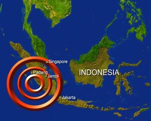
The U.S. Geological Survey said the quake, which hit at 4:02 a.m. (2102 GMT), was quite shallow at only 30 km (18.6 miles) deep and struck 135 km west of Bengkulu.
"There has been no tsunami so far and up until now there is no damage or casualties," Firwan Chairil of the National Disaster Management Office in Jakarta said by telephone.
An official at the Honolulu-based U.S. Pacific Tsunami Warning Center said his agency had told the Indonesian government of a possible small and localized tsunami.
PTWC geophysicist Gerard Fryer said that if a tsunami had occurred it would only threaten an area about 100 km (65 miles) from the epicenter and would probably be less than one meter (three feet) high.
The Indonesian meteorological agency, which put the quake at a depth of 10 km, issued a tsunami warning immediately after the tremor but lifted it later.
"The quake was felt strongly, but I did not panic because I have got used to it. So far we haven't received any reports of damage or casualties," a police officer in Bengkulu said.
The same area was hit by a more powerful quake of magnitude 8.4 last month that killed at least 25 people and toppled thousands of homes.
A series of tremors have struck the area in recent weeks.
Mahudi, a local Red Cross official in Bengkulu, also said there did not appear to have been any damage after Thursday's quake.
"It was felt very strongly because our post is in the coastal area. But there was no panic and no buildings have collapsed so far in Bengkulu."
Indonesia suffers frequent earthquakes, located in an area of intense seismic activity on the "Pacific Ring of Fire."
A huge earthquake measuring more than 9 struck off Sumatra on December 26, 2004, causing a massive tsunami and more than 230,000 deaths in countries across the region.
(Additional reporting by Sandra Maler and Frances Kerry in Washington)


Reader Comments
to our Newsletter