Storms
S

Cloud Lightning

Saskatchewan flooding prompts 150-km closure of Trans-Canada

Image
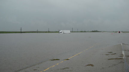
© Saskatchewan RCMPFlooding on the Trans-Canada Highway near Sintaluta, Sask. on Monday, June 21, 2011.
A large portion of the Trans-Canada Highway in eastern Saskatchewan is closed due to flooding.

A stretch of about 150 km - from Whitewood to Balgonie - of the province's main highway is closed in both directions due to deep water on the road near the village of Sintaluta, located about 85 km east of Regina.

The Saskatchewan government decided to close the highway Monday, when water up to 60 cm deep in some places drowned out the road.

The flooding was caused by heavy rains which fell over the past few days in the already soggy area.

Bizarro Earth

Summer enters Minnesota with a bang

Wind and rain blasted the metro area, causing power outages, but suspected tornadoes did little damage.

Image
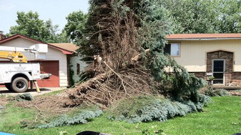
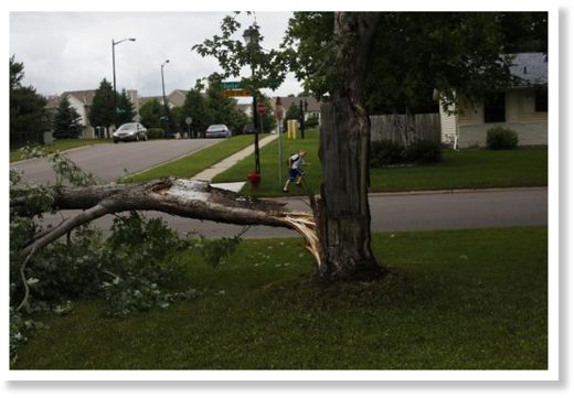
© Leslye Davis, Star TribuneStrong winds ripped a branch from a tree at 15122 Dunbar Court in Rosemount Tuesday afternoon. Lightning was the likely cause of an Eagan house fire.
Minneapolis - Summer barged into the metro area Tuesday with an afternoon outbreak of heavy rain, wind, tornado warnings and power-line takedowns, but no other serious damage.

More of the same is possible Wednesday and Thursday as a slow-moving low pressure system, more typical of winter or spring, creeps eastward across the region, said National Weather Service meteorologist Matt Friedlein.

Shortly after the midday summer solstice, observers reported funnel clouds over Willmar and Hutchinson, Minn., as well as Hampton and Coon Rapids in the metro area. Trees fell on some houses in the Coon Rapids and Blaine areas. Local and weather service officials were determining whether the damage was the result of a tornado.

Tornado sirens sounded across much of the metro area, including downtown St. Paul, where state Public Safety Commissioner Ramona Dohman and several staffers headed for an interior storm shelter after spotting a rotating funnel cloud several blocks away. But there were no reports of touchdowns.

Alarm Clock

US: Half-dozen tornadoes reported Monday in northwest Kansas

Four people were injured Monday when a tornado struck their rural Norton County home, state officials said.

The tornado was one of more than a half-dozen reported in northwest Kansas on Monday. There were no serious injuries, said Sharon Watson, a spokeswoman for the Kansas Division of Emergency Management.

At least three homes were damaged or destroyed outside Almena near the Nebraska line, Watson said.

Preliminary reports indicate most of the tornadoes were EF-0 or EF-1 and relatively short-lived, according to the Goodland branch of the National Weather Service. But one tornado, north of Hill City in Graham County, was rated an EF-3, which indicates wind gusts of 136-165 mph.

Tornadoes were also reported in Gove, Sheridan and Phillips counties. Hail as large as softballs was reported in Haskell County, and as large as baseballs in Graham County

No tornadoes were reported in the Wichita area, but powerful straight-line winds are blamed for damage near Maize and Valley Center. A metal shed was flattened near Hoover and 53rd Street North, and a semi was blown over two miles east of Maize on K-96.

Cloud Lightning

US: Tornado Warnings Rattle upper Midwest as Storms Hit

Tornado warnings were issued for parts of the Midwest on Tuesday night and the National Weather Service reported a possible tornado touchdown in a Minneapolis suburb that resulted in no injuries.

The renewed storm activity came less than a month after a massive tornado devastated Joplin, Missouri, and killed 155 people in the deadliest tornado to hit the United States in more than 60 years.

Attention

US: More Heavy Rain, More Flooding Problems for Minnesota

Image
© unknown
Rain, wind and lightning have knocked out power to thousands of customers in the Twin Cities metro area.

Xcel Energy says more than 8,000 customers were without service Tuesday morning.

And KARE 11's Jonathan Yuhas says the rough stuff might not be over.

More heavy downpours are likely Tuesday afternoon across the Metro area, which could lead to some spot flooding. Rain is forecast again on Wednesday with the potential for a few strong storms in the early afternoon hours from the Twin Cities Metro area east into Wisconsin.

All this moisture, on top of other recent heavy rains and thunderstorms are causing river levels to rise across Minnesota and western Wisconsin. The Minnesota, St.Croix and Mississippi Rivers will approach flood stage this week and remain near flood stage into the weekend.

Cloud Lightning

US: Heavy Rain Slams Monongahela Valley Area

Heavy storms pounded the Mon Valley early Monday morning, with torrential rains causing flood damage throughout the area, but mostly in Charleroi and Fallowfield.

According to Charleroi fire Chief Bob Whiten Jr., the Twilight basin off Lincoln Avenue Extension was hardest hit.

"We were out there for three hours last night," Whiten said. "It's the worst I've seen it in a long time."

Maple Creek Distributing was hit hard, but business was not affected.

"It's been a very long day," said Elaine McGaughey, who owns the business with her husband, Joe. "When I walked outside at 11 p.m. last night, the water was coming over the bridge."

The water did not reach levels high enough to affect merchandise.

The business' garage, located in the rear of the building, was filled with mud and debris, and a truck had to be hauled away after being swallowed by the water.

Cloud Lightning

US Iowa: Unexpected Storm in New Sharon

Image
© KCCI-TV/KCCI.comStorm damage in New Sharon, Iowa, on Monday, June 20, 2011.
People in the town of New Sharon are cleaning up today after a tornado touched down there early Monday morning. The National Weather Service says an EF-1 tornado touched down around 5 a.m.

No one was injured in the early morning storm, but the weather that hit the small community in southern Iowa left a half mile path of damage behind.

The strength of this storm surprised everyone from residents to the National Weather Service. Sunday night they issued an alert, but only for winds up to 50 miles an hour. It was a shock to everyone when a tornado formed bringing winds up to 110 miles an hour.

"One of my tenants said, I hate to tell you but your 1971 Charger is in ditch and your building is across the road in the cemetery," says Terry Anderson, who owns a storage company in New Sharon.

It wasn't the wake up call Anderson wanted to hear. When he finally arrived at his company, he stumbled into a disaster area. The tornado winds were so strong, they sucked up the foundation of his building and carried 60 pound pieces of wood over one 100 yards away.

"We had no warning on this one. We usually get one if we have a severe thunderstorm coming at us, they give us warning to alert us and can decide if we want spotters out. This one we didn't have anything," says New Sharon Fire Chief Steve Gerard.
Igloo

US: Snow Falling in Colorado on Eve of Northern Hemisphere's Summer Solstice

Image
© Sky-Hi Daily NewsThe unofficial snow report from a picnic table at Arapahoe Basin shows 6 new inches Monday morning. The ski area is closed this week but will be open Fri-Sun through Fourth of July weekend. Arapahoe Basin / Facebook page
The calendar says summer starts tomorrow in the Northern Hemisphere. The snow falling in the mountains of Colorado tells a different story.

A storm that has prompted a tornado watch across Nebraska and Kansas today also left 2 to 4 inches of snow in the Rocky Mountains, said Joe Ramey, a weather service meteorologist in Grand Junction, Colorado.

"It is unusual," Ramey said. "Here it is the last day of spring."

A winter storm advisory has been posted in the mountains of Colorado above 10,000 feet until 6 p.m. local time, and at least one tornado was reported in Kansas, according to the weather service. The Northern Hemisphere summer starts at 1:16 p.m. New York time tomorrow.

Cloud Lightning

Hurricane Beatriz Lashes Pacific Resorts in Mexico

Image
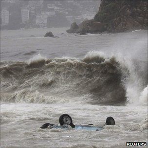
Surf's up: Waves whipped up by Beatriz sweep a car out to sea in Acapulco
Hurricane Beatriz has weakened to a tropical storm as it moves away from the east coast of Mexico.

Beatriz had been threatening some of Mexico's most popular resorts and left tourists sheltering in hotels, but all warnings have now been cancelled.

Pacific ports which were closed along the coast are gradually being reopened.

The US National Hurricane Center said winds had fallen to 110km/h (70mph) and were expected to continue weakening over the next two days.

The first Pacific hurricane - Adrian - formed earlier this month, causing no damage, but forecasters predict a busier hurricane season over the Atlantic.

Casualties have been light. One tourist is reported to have been injured by a falling tree in Acapulco.

The Mexican government issued a red alert for areas around the resort city of Manzanillo.

And hurricane warnings were issued along coast from Lazaro Cardenas north to Cabo Corrientes.

Stop

US: A generation of trees disappeared in the great Western Massachusetts tornado

Image
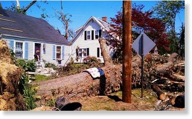
© UnknownWestern Massachusetts lost tens of thousands of mature trees in the June 1 tornado.
For the past few weeks we've been bringing you the stories of loss and destruction from the tornado that tore through Western Massachusetts on June 1.

The effects of the tornado will be felt for years to come, but one of its lasting legacies will be the loss of all the mature trees that once dotted the area's landscape.

Those beautiful trees that dotted places like Springfield's Court Square, and Wilbraham Mountain into Monson, took generations to mature, and just minutes to disappear.

"I think that I shall never see a poem as lovely as a tree," wrote American poet Joyce Kilmer almost 100 years ago. Chances are he was inspired by trees like the ones that now stand sideways and uprooted over many parts of the Pioneer Valley.