Storms
S


Cloud Lightning

Pakistan Floods: World Ignoring Humanitarian Crisis

The world is ignoring a growing humanitarian crisis in Pakistan's Sindh province where a second year of catastrophic floods has forced up to two million to flee their homes, washed away vital crops and left millions at risk of disease, according to aid agencies and local political leaders.


Bizarro Earth

Something Odd Is Happening With Namibia's Weather

Nambia's Weather
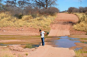
© Paul Bierman, UVMNormally dry Namibia river crossings weren’t dry this year; geologist Kyle Nichols stands in one.
Something's up with the weather in Namibia, say geoscientists Kyle Nichols of Skidmore College in Saratoga Springs, N.Y., and Paul Bierman of the University of Vermont in Burlington, Vt.

Nichols and Bierman should know. They're just back from the western mountains and coastal plain of this sparsely populated African country.

Usually, western Namibia is a dusty place where the stream beds are sand and the "lakes" are nothing more than flats of dried mud.

Not now.

This year, rivers with names like Swakop and Omaruru and Kuiseb flowed all the way to the sea - something they don't do often, "maybe once a decade," says Bierman.

The rivers didn't just flow for a day or two, Nichols and Bierman say, they ran from the desert to the ocean for weeks on end.

"There was so much water," says Bierman, "that people went swimming, they went tubing, and the desert turned green around rivers carrying so much sediment they were chocolate-brown."

The rains were unprecedented in both their intensity and duration. "There's nothing like this widespread, heavy rain in the historic record," says Nichols.

The two geoscientists have been working for more than a decade in Namibia, collecting samples of rock and river sediment and bringing them back for analysis at the University of Vermont (see Cosmogenic Nuclide Laboratory and Geomorphology Research Group's website).

Cloud Lightning

Canada: Maria becomes hurricane as it races toward Newfoundland

Image
© NASATropical Storm Maria satellite image
Tropical storm Maria has become a Category 1 hurricane as it races towards Newfoundland and Labrador.

The Canadian Hurricane Centre issued a statement late Thursday afternoon indicating Maria had now reached maximum sustained winds of 120 kilometres an hour.

CBC meteorologist Ryan Snoddon says the increased winds make Maria a Category 1 hurricane. He said it was moving toward Newfoundland at almost 60 kilometres an hour by early evening.

"It is expected to be a tropical storm," said Snoddon, "but perhaps just less than a Category 1 hurricane when it does approach.

Cloud Lightning

Heavy rains, floods kill 233, affect 5.5 million in Pakistan

floods,pakistan
© AFP/Getty ImagesCommuters on a flooded street following rains in Karachi on September 10.
Islamabad, Pakistan -- Heavy rains and flooding have killed at least 233 people in Pakistan, a disaster agency spokesman said Wednesday, as a weather forecast calls for more rain over deluged parts of the country.

Seven people have died in the past 24 hours, said Irshad Bhatti, a spokesman for the National Disaster Management Authority.

At least 5.5 million people have been affected by the flooding since August, said Zafar Iqbal Qadir, chairman of the disaster authority.

Bizarro Earth

Hurricane Katia whips up the surf as Britain is battered for a second day by high winds

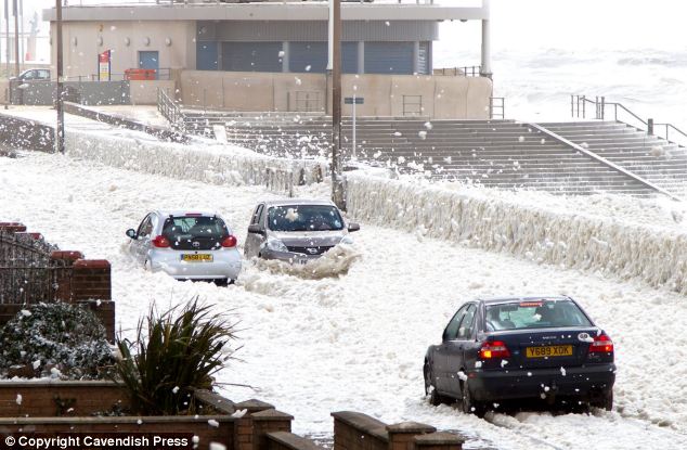
At first glance it looks like a scene from a winter postcard but this is in fact the surf whipped up by Hurricane Katia.

These cars were photographed driving along North Promenade at Cleveleys near Blackpool, Lancashire, where high winds have caused the surf from the sea to almost close the promenade because of the danger it poses to motorists.

Image
© Cavendesh PressWinter wonderland? Motorists battle their way through the surf at North Promenade at Cleveleys near Blackpool, Lancashire, where the high winds from Hurricane Katia have caused it to flood the road
The tail end of the hurricane battered Britain yesterday, bringing winds of up to 80mph and leaving a trail of devastation in its wake.

A motorist died and an 11-year-old boy was taken to hospital after the remnants of the worst storm in 15 years hit the UK's shores.

But although further blustery conditions were expected, today's winds were not as strong as they were yesterday, forecasters said.

Thousands were left without power last night as gusty weather caused damage to buildings and resulted in travel disruption around the UK.

In County Durham, a driver died when a tree hit a car on the A688 at Dunhouse Quarry, between Staindrop and Barnard Castle.

Durham Police said a passenger in the car was taken to hospital in Darlington with injuries which are not thought to be life threatening following the incident at about 3pm.

Cloud Lightning

Severe Flooding in Santa Catarina, Brazil

Brazil Flood
© RecreationThe city of Blumenau, in the state of Santa Catarina, southern Brazil.
Ten towns in the state of Santa Catarina in the South of Brazil are in an official state of emergency and a further 25 are on high alert, following several days of heavy rain and flooding. The situation looks likely to get worse, with more rain forecast for the coming days.

According to CIRAM (the Information Centre for Environmental Resources and Hydrometeorology in Santa Catarina), an average of more than 100mm of rain has fallen across the region in the last three days, causing rivers to rise dangerously and provoking landslides in several locations.

Cloud Lightning

Stormy Weather Across the UK as Remnants of Hurricane Katia Hit

As forecast, a deep area of low pressure which contains post-tropical storm Katia is bringing gales and heavy rain to parts of the UK.


All parts of the UK will see gusty conditions through the start of the week, with the highest wind speeds of 75 to 80 miles per hour expected over northern and western regions of the country.

Cloud Lightning

Ireland braced for extreme weather

The UK and Ireland will face extreme weather conditions in the coming days as the tailend of Hurricane Katia sweeps across the Atlantic.

The Met Office has issued a severe weather warning for most of the UK, advising those in the North as well as Scotland, to expect winds of up to 75mph.

Image
© UnknownNorthern Irish motorists have been warned about exposed roads
In Ireland, MET Éireann has also forecast strong southwest winds reaching speeds of 50 to 80 km/hr, gusting 90 to 130 km/hr, with the most severe winds affecting exposed regions of Connacht and Ulster on Monday morning.

Bizarro Earth

Eastern Caribbean Prepares for Heavy Rain, Winds as Tropical Storm Maria Approaches

Image
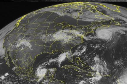
© AP Photo/Weather UndergroundThis NOAA satellite image taken Friday, September 9, 2011 at 1:45 PM EDT shows Hurricane Katia located about 385 miles south-southwest of Halifax, Nova Scotia.
Tropical Storm Maria swirled toward the eastern Caribbean on Friday, threatening to unleash heavy rain and wind on islands still struggling to recover from a recent hurricane.

The storm had maximum sustained winds of 45 mph (75 kph) Friday afternoon, with some slight strengthening possible, said the U.S. National Hurricane Center in Miami. It was centered about 215 miles (345 kilometers) east-southeast of the French Caribbean island of Guadeloupe and moving northwest at about 16 mph (26 kph).

Tropical force winds will start lashing the U.S. Virgin Islands on Saturday morning, where the storm is expected to dump up to 6 inches (15 centimeters) of rain, said Walter Snell with the National Weather Service office in Puerto Rico.

"Residents should be prepared for whatever the worst this storm can do," he said.

Cloud Lightning

Hurricane Katia heading for Irish and Scottish coasts

Image
© GettyHurricane Katia is heading to Britain
A hurricane is on a collision course with Britain, bringing 90mph winds and killer waves.

The sheer force of Hurricane Katia may hit western Ireland and north-west Scotland next Monday and Tuesday, US forecasters predict.

Winds of up to 90mph could cause a risk to shipping off the west coast of Ireland on Monday.

Katia will then reach Scotland and the Orkney Islands by Tuesday, according to the US National Hurricane Center in Miami.

Forecasters expect little change in its strength as the Gulf Stream propels the storm across the Atlantic.