Storms
S

Cloud Lightning

Baseball-Sized Hail in Forecast for Oklahoma and Texas

Image
© UnknownIllustration only
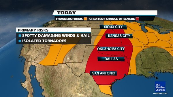
Storms are expected to sweep through the middle of the country over the next several days, bringing heavy rain and the threat of hail and tornadoes. Flood warnings stretch from southeast Texas north through western Missouri on Monday, but after a year of drought in much of the region and a largely snowless winter, fears of flooding aren't what they otherwise might be in several states, where the ground is expected to absorb inches of rain with ease.

The forecast for northern Texas and southeast Oklahoma also calls for baseball-sized hail, damaging winds and possibly tornadoes, according to the National Weather Service's Storm Prediction Center in Norman, Okla. Two tornadoes damaged homes and rail cars in North Platte, Neb., on Sunday.

Eight inches of rain are expected in southeastern Kansas, which has been unusually dry for nearly a year. The area has had less than three-fourths of the precipitation it typically gets since last April, state climatologist Mary Knapp said.

Cloud Lightning

Tornadoes strike Nebraska, flipping tractor-trailer and rail cars

Image
© The Weather Channel/Today
Severe storms overnight in Nebraska, Texas and Ohio damaged homes and tossed rail cars as well as at least one tractor-trailer, and the threat continued Monday with a large part of the central U.S. on alert.

The greatest damage overnight was just outside North Platte, Neb., where two confirmed tornadoes tore roofs off several homes, downed power lines and injured two people.

One twister crossed Interstate 80, flipping a tractor-trailer in its path. The truck's driver was hospitalized.

A rail yard also was hit, with 15 cars derailed or knocked over, the North Platte Telegraph reported. One worker there was hit by flying debris, treated at a hospital and then released.

๏ปฟ๏ปฟIn central Ohio, tornado sirens went off as large hail and high winds swept through Sunday night. In Gardendale, Texas, two people were hurt when high winds flipped over their mobile home. No tornadoes were reported in either state.

The mix of warm weather in recent weeks with cold pockets across the Midwest and central U.S. has led to an early start to the tornado season.

"It has been an active season already for tornadoes, and that's part of the reason we've scooched up our siren testing starting in March," Paul Johnson, emergency manager for Douglas County in North Dakota, told KETV.

Tornado watches have been issued for parts of Texas and Oklahoma for Monday, while the rest of the central U.S. is under severe weather warnings that include the possibility of large hail and high winds.

The threat will shift slightly to the east on Tuesday, weather.com reported, with parts of Illinois, Arkansas, Louisiana and Texas seeing the biggest threat.

Igloo

Arizona cities buried in rare snowstorm as much of U.S. enjoys balmy weather

Image
© Joshua Lott/REUTERSFlagstaff, Arizona was hit with a late winter storm that dumped more than of foot of snow in the area on March 18.
A winter storm and high winds struck parts of Arizona and New Mexico on Sunday, causing hazardous driving conditions, power outages and school cancellations. The fast moving storm forced the National Weather Service to place parts of northern New Mexico under a winter storm warning until midnight Monday as heavy snow and wind from Arizona quickly blanketed the area.

The electric company PNM reported that around 33,000 customers were out of power at one point Sunday afternoon in the Albuquerque area due to high winds. A spokesman for PNM said emergency crews were working to restore power, and by 9 p.m. the number without electricity was down to 4,500.

Heavy winds and blowing dust forced the closure of parts Interstate 10 in southern New Mexico due to low visibility, but the road was back open later in the day. A flight carrying the University of New Mexico men's basketball team home after its loss in the NCAA tournament was delayed due to high winds.

Arizona Department of Transportation crews were fully deployed Sunday after heavy snow in Arizona fell from Flagstaff to the White Mountains. The winter storm forced officials to temporary close Interstate 40 in both directions and parts of Interstate 17. Both highways later reopened Sunday afternoon.

Umbrella

Australia: Cyclone Lua hammers the Pilbara region


As residents in Western Australia's Pilbara region assess the damage caused by Tropical Cyclone Lua overnight, Queensland's Gulf communities are being warned to prepare for a cyclone heading their way.

Pilbara residents emerged from a night of wild weather this morning after a cyclone crossed the coast north of Port Hedland as a category four system yesterday afternoon, before later weakening to category two strength.

There are reports of extensive damage at the small community of Pardoo, while Nullagine, Newman and Marble Bar were also in the firing line overnight.

Cloud Lightning

St. Patrick's Day Strong Storms: Missouri to Indiana

Image
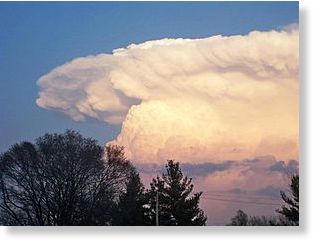
© Paul KPhoto of a towering thunderstorm cloud, submitted by AccuWeather.com Facebook fan Paul K. on Saturday.
Strong thunderstorms are threatening to ruin St. Patrick's Day celebrations from southern Missouri to southern Indiana into this evening.

The stage is set for potent thunderstorms to erupt from St. Louis and Poplar Bluff, Mo., to Louisville, Ky., with record warmth and moist air in place.

Other cities at risk include Cape Girardeau, Mo., Paducah, Ky., and Evansville, Ind.

Some of the same areas being threatened this St. Patrick's Day were the targets of the massive tornado outbreak earlier this month.

A repeat of that outbreak is not expected since any tornado that touches down into this evening will be an isolated event. Damaging winds, hail and downpours are greater concerns.

Cloud Lightning

Washington state dust storm

A severe dust storm sweeps through Washington state, causing five vehicles to crash on a major road 160 miles south-east of Seattle. State officials closed the road for five hours. One man was taken to hospital for treatment, according to Washington state police


Evil Rays

Scientists detect unusual seismic signals from tornado

Image
© Unknown
An Indiana University geophysical experiment detected unusual seismic signals associated with tornadoes that struck regions across the Midwest last week - information that may have value for meteorologists studying the atmospheric activity that precedes tornado disasters. The experiment by IU researchers involves deployment of more than 100 state-of-the-art digital seismographs in a broad swath of the U.S. midcontinent. One of the twisters that struck southeastern Missouri and southern Illinois on Feb. 29 passed through the seismic detection array.

"In examining the seismograms, we recorded unusual seismic signals on three of our stations in southern Illinois," said Michael Hamburger, professor in the department of geological sciences at IU Bloomington and one of the researchers conducting the experiment. "The seismograms show a strong, low-frequency pulse beginning around 4:45 a.m. on Feb. 29. Our preliminary interpretation, based on other seismic records of tornadoes, suggests that we were recording not the tornado itself, but a large atmospheric pressure transient related to the large thunderstorms that spawned the tornadoes."

Attention

White Cliffs of Dover Suffer Large Collapse

Thousands of tons of chalk from the famous White Cliffs of Dover have collapsed into the sea following a huge rockfall.

Tons of cliff-face sheared off near an area known as Crab Bay, but no-one was injured, the coastguard said.

The collapse may have been caused by rain over the winter months being absorbed into the chalk and freezing.
White cliff rockslide
© John McLellanAn aerial view of the latest chalk slip at the White Cliffs of Dover
The collapse may have been caused by rain over the winter months being absorbed into the chalk and freezing here.

Comment: Considering the sentimental value the Cliffs have for the British people, a collapse of this magnitude could be taken as a symbol of their current state.


Cloud Lightning

NASA sees double tropical trouble in northern Australia

When NASA's Aqua satellite passed over northern Australia on March 12 at 1711 UTC and March 13 at 0539 UTC it captured the two tropical disturbances close enough to appear on one image. Tropical Cyclone Lau appears on the left side of both days of satellite imagery, while System 96P appears on the right side of the images. Lua is located in the Southern Indian Ocean, while System 96P is in the Southern Pacific Ocean. Both systems seemed to grow closer over the two days and both are affecting coastal areas in northern Australia on March 13.

Aqua captured an infrared image of both storms' cloud top temperatures using the Atmospheric Infrared Sounder (AIRS) instrument. AIRS data showed that the coldest cloud top temperatures were colder than -63F/-52.7C around the center of circulation in both systems.
Image
© NASA/JPL, Ed Olsen

Cloud Lightning

Louisiana: 15 inches of rain in five hours


States of emergency were in force Tuesday in four Louisiana parishes after torrential rain left homes and roads under several feet of water. Hundreds fled their homes and dozens of motorists had to be rescued.

Flooding closed the major highway through St. Landry Parish, and many roads across the four parishes remained closed on Tuesday.

"In my 28 years in law enforcement I have never seen the interstate closed," St. Landry Sheriff's Capt. Jimmy Darbonne told weather.com.

Dozens of homes in Carencro, a town in Lafayette Parish, were evacuated on Monday when some 15 inches of rain fell within five hours.

"We had up to 7 feet of water on some streets," said Capt. Kip Judice, the local sheriff's spokesman. "We had no deaths or injuries but a lot of near calls."