Storms
S

Bad Guys

Rare Waterspout Spotted on Video Near Hawaii


A rare waterspout formed off the coast of Hawaii yesterday (May 2), and was caught in several pictures and videos.

Waterspouts, tornadoes that touch on water, are not themselves made of water; they are funnel clouds that shoot down from storm clouds. This "tornado on water" touched down over the ocean off Ala Moana, a district of Honolulu.

In areas where intense funnel clouds commonly form over water -- the Florida Keys and the Adriatic Sea are two examples -- waterspouts will frequently form along a line of developing thunderstorms.

That was the case yesterday, as an intense lightning storm with heavy rains knocked out power for 60,000 residents, according to the Hawaiian Reporter. The heavy rains soaked Honolulu and triggered a flash flood warning.

Cloud Lightning

US: Kentucky - More Heavy Rains, Flooding Concerns

Heavy rains have returned to the Bluegrass.

Image
© WTVQ
Lexington has been receiving the rains throughout the morning, and it will continue falling throughout the day.

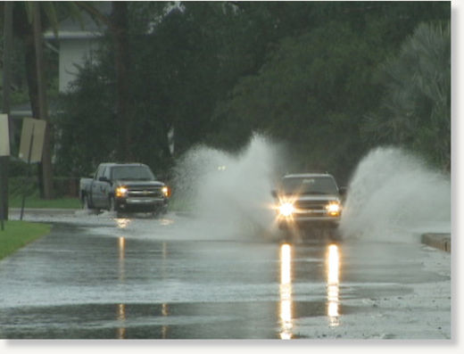
Areas in Franklin, Woodford, and Scott counties are also seeing heavy rains bring causing big concerns for drivers as water is ponding on roadways.

As flooding intensifies in western Kentucky, the commonwealth has opened a Regional Emergency Coordination Center at the Benton Armory in Marshall County. The center assists local emergency response efforts, allowing local, state, and federal officials to coordinate broad emergency responses across the region. Governor Steve Beshear is planning to return to western Kentucky, where flooding has forced evacuations and National Guard troops
have been sent in to help.

Beshear was planning to visit Paducah, Hickman and Benton today. On Monday, officials said more than 100 troops were helping with evacuations in the cities of Ledbetter in Livingston County and Hickman in Fulton County. Smithland was also being evacuated. The lower Ohio River is expected to crest at 58 feet, three feet above an earlier prediction.

Cloud Lightning

US: Hawaii forecast calls for another day of wild weather

There is a weather disturbance nearby that has triggered the thunderstorms, heavy rains and even hail on Kula, Maui.


Currently most of the storm activity is centered over Maui county and Oahu.

However, downpours occurred over all islands from the Big Island and Kauai included.

Molokai and Lanai are seeing heavy downpours and on Oahu the heavy's rains are over central Oahu near Milalani but could move on to other areas.

Igloo

Winter in May? Its snowing in Poland!

Wroclaw in snow
© ForumWroclaw in the snow, May 2011
About 10 thousand people in Lower Silesia region are left without electricity due to the heavy snowfall.

Wet, heavy snow broke branches in many places, damaging power lines of high and medium voltage.

Bad Guys

US: A Record 226 Tornadoes Recorded Over 24 Hours Last Week


According to the National Weather Service, 226 tornadoes were recorded from Wednesday morning to Thursday morning, and that's a record for a 24-hour period.

From Wednesday to Friday, 312 tornadoes may have formed.

The previous record for a single weather event was April 3-4, 1974, when 148 twisters were recorded.

Read the details in the preliminary report from the National Oceanic and Atmospheric Administration.

Cloud Lightning

New Zealand: Tornado hits Auckland shopping mall: one dead

A tornado has cut a path of devastation through Auckland this afternoon, killing one person and injuring more than twenty.


Witnesses reported cars with people inside being tossed across carparks when the tornado ripped through the suburb of Albany like a freight train about 3pm.

It was earlier reported that two had died, but it was later said there had been confusion in the immediate chaos.

Bizarro Earth

US: Levee in flood area to be blown up; dam spills over

Water breaches levee
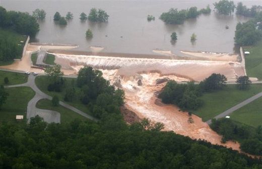
© Paul Davis / The Daily American Republic via APWater flows over the Wappapello Lake emergency spillway on the St. Francis River in Wayne County, Mo., on Monday. Several roads have been closed in southeast Missouri after heavy overnight rains pushed lakes and streams out of their banks.
Army Corps of Engineers gives green light after pumping in liquid explosives

Cairo, Illinois - As more rain fell Monday across southeast Missouri on Monday, water spilled over one dam, forcing road closures, while the U.S. Army Corps of Engineers gave the go-ahead to blow up a levee in another county.

In Wayne County, water burst through the Wappapello Lake emergency spillway on the St. Francis River. Several roads were closed there and in other areas as lakes and streams were pushed out of their banks.

In nearby Mississippi County, the Army Corps of Engineers decided to blast a levee, flooding farmland but protecting an Illinois town where most residents already have been forced to flee from a rising river.

Cloud Lightning

U.S.: Flooding in central Arkansas

Image
It's been a turbulent spring thus far in Arkansas and this weekend was no exception.

Here in central Arkansas, flood conditions rolled in with the rains that started Saturday night and continued through Sunday. According to the National Weather Service, four to eight inches of rain fell during the weekend and more heavy rain is in the forecast through Tuesday.

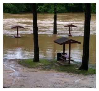
Here in Benton, the Saline River serves as a handy guide as to how much rain has fallen. If the river is out of its banks, it's a sure bet that heavy rains are common throughout Saline County. The Saline River was out of its banks, indeed, and the following pictures taken about 6 p.m. in Benton on Sunday are proof.

Cloud Lightning

US: Mississippi heavy rains and freeze warnings for the plains

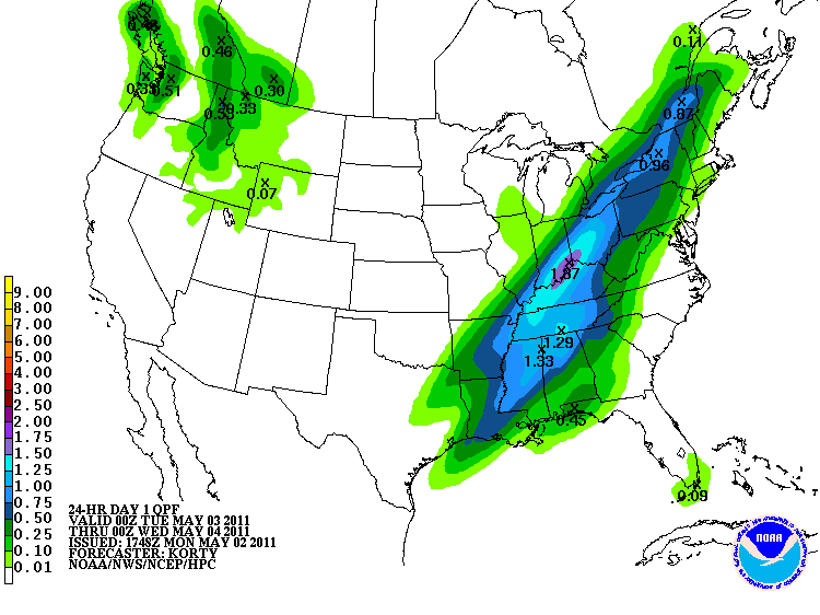
Heavy rain is the major story for this early Monday morning. A slow-moving cold front is forcing big downpours over the Mid MS valley this morning, and it's falling over the flood-out areas from this weekend. The radar has the rain over TX (which is actually very good news, it will help control the crazy wild fires), goes to OK and up to the NE right now. I'll show it to you on the program, and it looks like around 2-3" will fall over the mid MS Valley area. Check out the map:

Image

Cloud Precipitation

Rain, north wind could put record chill on Dallas-Fort Worth, but warm-up ahead

May continued its cold, soggy start Monday as heavy rains swamped highways and a stiff north wind chilled Dallas-Fort Worth.

Accidents snarled traffic on highways throughout the area, and there was minor flooding reported on low-lying roads.

The storms brought much-needed rain to the area, but the cold front that accompanied it was less welcome.

A high in the low 50s is expected Monday, which would be the coldest high ever. The previous record was 57, set in 1994.