Earthquakes
S


Bizarro Earth

USGS: Earthquake Magnitude 7.2 - ENE of Kuril'sk, Russia

Russia Quake_190413
© USGS
Event Time
2013-04-19 03:05:53 UTC
2013-04-19 15:05:53 UTC+12:00 at epicenter

Location
46.182°N 150.796°E depth=122.3km (76.0mi)

Nearby Cities
250km (155mi) ENE of Kuril'sk, Russia
521km (324mi) NE of Nemuro, Japan
527km (327mi) NE of Shibetsu, Japan
566km (352mi) ENE of Abashiri, Japan
1490km (926mi) NE of Tokyo, Japan

Technical Details

Bizarro Earth

Japan's volcanic island rocked by dozens of earthquakes

Image
More than a dozen earthquakes, one of them magnitude 6.2, rocked a volcanic island south of Tokyo Wednesday, the national meteorological agency said. There were no immediate reports of injuries or property damage from any of the quakes and no risk of a tsunami, the agency said. The biggest tremor, with its epicenter located near Miyake Island some 180 kilometers (110 miles) south of Tokyo, was registered at around 5:57 pm (0857 GMT), the Japan Meteorological Agency said.

"There may be slight changes in the level of sea along Japan's coast but there is no fear of damage resulting from this quake," the agency said. There had been 13 minor quakes near the island - an active volcano - since 10:15 am (0115 GMT) Wednesday. A small earthquake was also registered four minutes after the 6.2-magnitude tremor, the agency said. The volcano erupted in 2000, forcing all 3,800 islanders to evacuate. Many of them have since returned to the island. - ASIA ONE

Bizarro Earth

USGS: Earthquake Magnitude 6.8 - ESE of Aitape, Papua New Guinea

PNG Quake_160413
© USGS
Event Time
2013-04-16 22:55:26 UTC
2013-04-17 08:55:26 UTC+10:00 at epicenter

Location
3.178°S 142.514°E depth=8.0km (5.0mi)

Nearby Cities
19km (12mi) ESE of Aitape, Papua New Guinea
130km (81mi) WNW of Wewak, Papua New Guinea
145km (90mi) ESE of Vanimo, Papua New Guinea
213km (132mi) ESE of Jayapura, Indonesia
863km (536mi) NW of Port Moresby, Papua New GuineaTechnical Details

Bizarro Earth

Iran's massive 7.8 magnitude earthquake explained

Image
The Iran earthquake arriving on a seismometer at Keele University in the UK.
The strongest earthquake to hit Iran in more than 50 years was a subduction-zone quake - the same tectonic setting underlying deadly temblors in Japan, Chile and Indonesia.

The magnitude-7.8 Khash earthquake struck 51 miles (82 kilometers) beneath the Earth's surface, where the Arabian Plate dives under the massive Eurasian Plate, the U.S. Geological Survey (USGS) reported. The quake hit today (April 16) at 3:14 p.m. local time (6:44 a.m. EDT). Shaking was felt from New Delhi to Dubai, and dozens of people have been reported killed by collapsed structures, according to news reports. The USGS said that there will be more than a 47 percent chance of more than 1,000 fatalities.

Known as the Makran subduction zone, the plate boundary has produced some of the Middle East's biggest and deadliest earthquakes. For example, in November 1945, a magnitude-8.0 earthquake in Pakistan triggered a tsunami within the Gulf of Oman and the Arabian Sea, killing more than 4,000 people.

Considering subduction-zone earthquakes can strike nearly 435 miles (700 km) deep in the Earth, today's quake was likely within the Arabian Plate itself, not along the zone where the two massive slabs meet, said Bill Barnhart, a research geophysicist with the USGS in Denver.
Ambulance

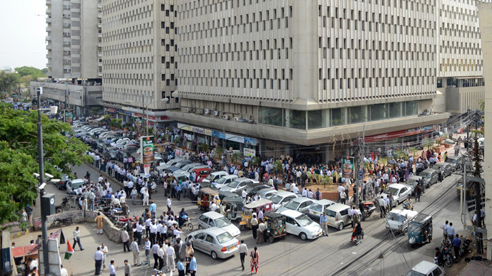
At least 34 dead as Pakistan jolted by powerful Iran quake

Image
© Agence France-Presse/Assif HassanPakistanis are pictured outside after evacuating nearby buildings following tremors in Karachi on April 16, 2013
At least 34 people were killed in southwestern Pakistan on Tuesday when it was hit by tremors from a 7.8 magnitude earthquake in neighboring Iran, Pakistani officials said.

The epicenter was located in southeast Iran in an area of mountains and desert, about 200 km (125 miles) southeast of Zahedan and 250 km northwest of Turbat in Pakistan, the US Geological Survey said, Reuters reported.

Three women and two children were killed when their mud house collapsed in the district of Panjgur in the Pakistani province of Baluchistan.

"The earthquake has killed at least five people in Panjgur," said Ali Imran, an official of the Provincial Control Room, a government disaster-response unit in Quetta, the main city in the region.

Bizarro Earth

USGS: Earthquake Magnitude 4.3- 12km ENE of Luther, Oklahoma

Image
© USGS
Event Time:
2013-04-16 06:56:30 UTC
2013-04-16 01:56:30 UTC-05:00 at epicenter

Location:
35.685°N 97.066°W depth=5.0km (3.1mi)

Nearby Cities:
12km (7mi) ENE of Luther, Oklahoma
27km (17mi) NE of Choctaw, Oklahoma
37km (23mi) E of Edmond, Oklahoma
39km (24mi) NE of Midwest City, Oklahoma
47km (29mi) ENE of Oklahoma City, Oklahoma

Technical Data

Bizarro Earth

USGS: Earthquake Magnitude 7.8 - 83km E of Khash, Iran

Image
© USGS
Event Time:
2013-04-16 10:44:20 UTC
2013-04-16 15:14:20 UTC+04:30 at epicenter

Location:
28.107°N 62.053°E depth=82.0km (51.0mi)

Nearby Cities:
83km (52mi) E of Khash, Iran
168km (104mi) NE of Iranshahr, Iran
192km (119mi) SE of Zahedan, Iran
232km (144mi) SSW of Rudbar, Afghanistan
606km (377mi) NE of Muscat, Oman

Technical Data

Bizarro Earth

USGS: Earthquake Magnitude 6.6 - WSW of Panguna, Papua New Guinea

PNG Quake_140413
© USGS
Event Time
2013-04-14 01:32:27 UTC
2013-04-14 11:32:27 UTC+10:00 at epicenter

Location
6.504°S 154.548°E depth=64.3km (40.0mi)

Nearby Cities
105km (65mi) WSW of Panguna, Papua New Guinea
114km (71mi) WSW of Arawa, Papua New Guinea
347km (216mi) SE of Kokopo, Papua New Guinea
498km (309mi) ESE of Kimbe, Papua New Guinea
677km (421mi) WNW of Honiara, Solomon Islands

Technical Details

Bizarro Earth

USGS: Earthquake Magnitude 6.0 - NW of Sumoto, Japan

Japan Quake_120413
© USGS
Event Time
2013-04-12 20:33:16 UTC
2013-04-13 05:33:16 UTC+09:00 at epicenter

Location
34.413°N 134.827°E depth=5.3km (3.3mi)

Nearby Cities
9km (6mi) NW of Sumoto, Japan
20km (12mi) NNE of Fukura, Japan
28km (17mi) SSW of Akashi, Japan
32km (20mi) NE of Naruto, Japan
465km (289mi) WSW of Tokyo, Japan

Technical Details

Bizarro Earth

USGS: Earthquake Magnitude 6.3 - SE of Bandar Bushehr, Iran

Iran Quake_090413
© USGS
Event Time
2013-04-09 11:52:50 UTC
2013-04-09 16:22:50 UTC+04:30 at epicenter

Location
28.500°N 51.591°E depth=10.0km (6.2mi)

Nearby Cities
89km (55mi) SE of Bandar Bushehr, Iran
92km (57mi) SSE of Borazjan, Iran
103km (64mi) WSW of Firuzabad, Iran
124km (77mi) S of Kazerun, Iran
272km (169mi) NNE of Manama, Bahrain

Technical Details