Earthquakes
S


Attention

Earthquake measuring 5.4 shakes Argentina

Image
A major earthquake was reported by the United States Geological Survey (USGS) on Sept. 28, 2015, following a series of tremors in South America. Today's seismic activity so far has produced a 5.4 magnitude earthquake, 32 miles northwest of San Antonio de Los Cobres, Argentina. During the last 10 days, the adjoining countries of Argentina and Chile have experienced tremors measuring between 5.4 and 6.6 on the Richter Scale. Also, this morning, Honduras, which is approximately 3900 miles north of Argentina experienced 5.1 magnitude tremor, only 30 minutes earlier.

The seismic activity occurred on the Nazca plate region, which includes the offshore plate that has been jolting Chile's coastal city, Coquimbo, for the past several weeks. The largest tremor measured an 8.3 on the Richter Scale Sept. 17, 2015. CNN reported one million people were evacuated before this earthquake, which also put the region on a tsunami watch, as far away as New Zealand, over 6,000 miles from the epicenter.

Attention

3.9 magnitude earthquake hits Redwood Valley in Northern California

Image
A 3.9 magnitude earthquake struck Northern California's Redwood Valley area Monday and was quickly followed by a 2.7 aftershock, according to the U.S. Geological Survey

A quake hit the region about 2:30 p.m., followed a half-hour later by the aftershock, officials said.

There were no immediate reports of injuries or damage.

In August, a 4.0 earthquake shook up the Bay Area, with an epicenter in Oakland.

Attention

Magnitude 5.1 earthquake recorded off Fiji

Image
An earthquake measuring a magnitude of 5.1 on the Richter scale was recorded at 10.21pm last night 353.68 kilometres off Nukuni Village in Ono-i-Lau Islands.

This was confirmed in a statement from the Mineral Resources Department, Seismology section in Suva this morning.

The evaluation report confirm that a moderate size earthquake with deep depth source location occured, however, it does not pose any threat to the region and they will keep monitoring the situation for any further updates.

Attention

Caribbean shaken by 4 earthquakes

Image
Four earthquakes with magnitudes ranging from 3.8 to 4.5 rattled the Caribbean on Sunday but there were no immediate reports of injuries or damages, according to the Trinidad-based Seismic Research Unit of the University of the West Indies (UWI).

It said that early Sunday, an earthquake with a magnitude of 3.8 struck 123 kilometers north-east of Bridgetown.

The 5.00 am (local time) quake, with a depth of 70 kilometres, was also located 254 kilometres east of Castries, St Lucia and 279 kilometres east south east of Fort-de-France in Martinique.

Attention

Earth moved 140cms (4 feet and 7.12 inches) after Chile earthquake: Scientists

Image
Satellite images show earth displaced by 140cm after the 16 September quake in Chile
The Earth was displaced by 140cms after a massive 8.3 earthquake rocked Chile's north coast on September 16, according to satellite images taken before and after the temblor, which were analysed by scientists, using a technique — called Synthetic Radar Aperture Interferometry (InSAR) .

This technique combines before and after satellite images into colorful maps — called interferograms.

The rainbow-colored fringes, which can be similarly interpreted as the elevation contours on a map, help scientists approximate how far the ground moved on a fault following an earthquake. The European Space Union launched the spacecraft that took these images, called Sentinel-1, in the Spring of 2014. It orbits about 430 miles above Earth and uses radar to sense ground movements.

Attention

4.7-magnitude earthquake strikes northwest Nevada; third in 10 months

Image
The U.S. Geological Survey reports that a 4.7-magnitude earthquake hit the northwest corner of Nevada on Saturday night — the third earthquake of this size to hit the region in the past 10 months.

The USGS says the earthquake, which had its epicenter about 38 miles southeast of Lakeview, Oregon, hit at 7:44 p.m.

There are no reports of damage in the region.

On Sept. 14, a 4.7-magniture earthquake hit the Shelton National Wildlife Refuge near the Oregon and California borders.

That earthquake was the second of 4.7 magnitude to hit the Sheldon wildlife refuge. The first one, recorded on Nov. 6, 2014, was the largest one to hit since the thousands of earthquakes started in July 2014.

Source: The Associated Press

Attention

Earthquake measuring 5.7 in the Banda Sea rocks residents 600 kilometres away in Darwin, Australia

Image
A seismometer recorded the 5.7 magnitude quake at about 12.30pm on Sunday
Darwin residents have reported feeling an earthquake from the the Indonesian islands.

The 5.7 magnitude quake took place about 600km north of Darwin in the Banda Sea just before 12.30pm on Sunday.

Most of the reports came from residents in the northern suburbs, but those from the rural areas as far south as Batchelor also felt tremors, reports NT News.

Solar Flares

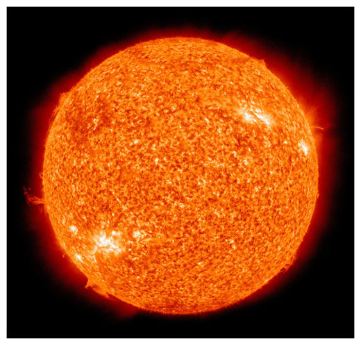
Studies suggest sun triggers massive earthquakes

The Sun
© Wikipedia Commons
The sun is triggering the deadliest earthquakes on the planet, including the recent M8.3 earthquake in Chile on September 16, 2015 and deadly tsunami that followed, according to two papers to be published October 5th in New Concepts in Global Tectonics. The papers investigate fluctuations in the magnetic field activity of the sun and found a statistically significant relationship between M8+ earthquakes and the extremes and reversals in magnetism of solar polar magnetic fields.

The team first announced the results in August 2014, and recently used the methods proposed in that study to provide evidence that a recent major earthquake fit the patterns observed in the foundational study. In early 2014, Dr. Christopher Holloman's team of researchers at The Ohio State University Statistical Consulting Service was able to construct a model that exhibited very strong agreement between solar magnetism patterns and the occurrence of large earthquakes.

Dr. Holloman warned that formal testing of the model can only be performed by examining its performance over the next few years, but that the agreement was sufficient to suggest that a relationship likely exists between solar polar fields, or magnetic fields associated with the north and south poles of the sun, and large earthquakes. Now we have a subsequent event that appears to comport with the initial study.

"This type of confirmation is merely the first step, but it is certainly a positive one," notes lead author Ben Davidson of SpaceWeatherNews LLC, "we were already in the process of investigating large seismic events since the end-date of our initial study when the Chile disaster occurred, and we hope to have further publications covering those events in more detail in 2016." The second paper was submitted by Davidson alone, and was restricted to analysis of the Chile earthquake in order to accompany the initial study.

X

Two moderate earthquakes hit Cartago province, Costa Rica

Image
© Tico Times
A moderate earthquake jolted residents in Cartago and San José provinces at 8:45 a.m. Saturday. No damage was reported.

The National University's Volcanological and Seismological Observatory of Costa Rica (OVSICORI) reported the temblor as a magnitude-4.6. The University of Costa Rica's National Seismological Network (RSN) registered a magnitude of 4.5.

Both agencies reported the epicenter in the province of Cartago, 17 kilometers east of Turrialba canton. The quake struck at a depth of 19 kilometers and was felt across most of the Central Valley.

People reported via OVSICORI's and RSN's social media accounts that the temblor as "very strong" in the Cartago communities of Agua Caliente, Turrialba, Tejar and Tres Ríos. Reports from San José came mostly from residents east of the capital in Curridabat, Zapote, San Pedro and Patarrá.

At 10:03 a.m. a magnitude-2.8 earthquake hit the same area, its epicenter located 5 kilometers west of the first one. The later quake, however, went mostly unnoticed by people in the area, according to preliminary reports from OVISCORI and RSN.

Attention

4.6 magnitude earthquake hits Assam, India

Image
An earthquake of moderate intensity jolted India's northeastern states and parts of Bhutan on Friday night, officials said. There were no immediate reports of casualties or damage to property.

"The quake, measuring 4.6 on the Richter Scale, occurred at 10.27 pm and had its epicentre in Assam's Darrang district bordering China," said an official of the meteorological department.

The earthquake was felt in some parts of Assam, Arunachal Pradesh, Meghalaya, and adjoining areas of northeastern region, besides parts of Bhutan.

It lasted for about 10 to 12 seconds.

India's northeast is considered the sixth major earthquake-prone belt in the world.