Earthquakes
S


Bizarro Earth

'Loud blasts heard' - Earthquake strikes Viet Nam

Image
© Tuoi TreThousands of residents rushed out from their houses when the 4.6 degree quake hit Bac Tra My District in Quang Nam Province last night
An earthquake, the strongest since 1957, occurred last night in Quang Nam Province's Bac Tra My District, where the Song Tranh 2 Hydropower Plant is located, panicking thousands of local residents.

A series of tremors measuring 4.6 on the Richter scale broke out in the district at 9:42 pm Monday and lasted for about three seconds, said Le Van Tuan, chief of the district People's Committee's Secretariat.

Thousands of locals rushed out of their houses in panic after they heard loud blasts and felt the ground shaking, houses' walls cracking, and things inside the houses falling, Tuan said.
"Many items on a table in my house fell down to the floor and my children cried and screamed when hearing explosions that sounded like the sounds of bombings," he said.

Comment: This earthquake, or whatever it was, does not show up on USGS. The recent quakes may be reservoir induced. There was a similar earthquake September 4th, 2012, that also wasn't registered on USGS. Of course, this in itself isn't proof that there wasn't an earthquake - nor can it be ruled out that some type of 'overhead activity' could have caused the loud explosions.

Bizarro Earth

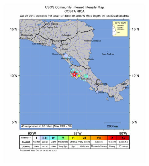
USGS: Earthquake Magnitude 6.6 - NE of Hojancha, Costa Rica

CostaRica Quake_241012
© USGS
Event Time
2012-10-24 00:45:36 UTC
2012-10-23 18:45:36 UTC-06:00 at epicenter

Location
10.118°N 85.348°W depth=39.5km (24.5mi)

Nearby Cities
10km (6mi) NE of Hojancha, Costa Rica
11km (7mi) ESE of Nicoya, Costa Rica
30km (19mi) ESE of Santa Cruz, Costa Rica
44km (27mi) SW of Canas, Costa Rica
140km (87mi) W of San Jose, Costa Rica

Technical Details

Bizarro Earth

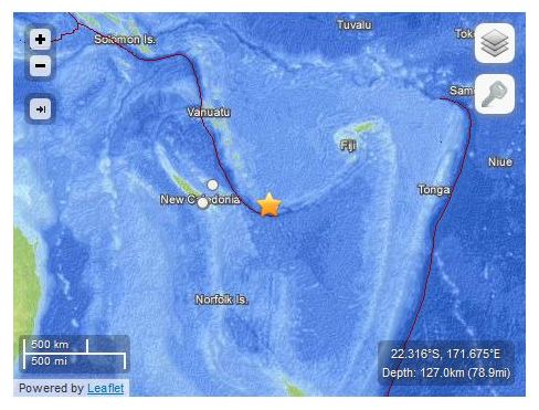
USGS: Earthquake Magnitude 6.0 - WNW of Ile Hunter, New Caledonia

Hunter Quake_231012
© USGS
Event Time
2012-10-23 09:39:31 UTC
2012-10-23 20:39:31 UTC+11:00 at epicenter

Location
22.316°S 171.675°E depth=127.0km (78.9mi)

Nearby Cities
39km (24mi) WNW of Ile Hunter, New Caledonia
482km (300mi) ESE of We, New Caledonia
524km (326mi) E of Mont-Dore, New Caledonia
537km (334mi) E of Noumea, New Caledonia
538km (334mi) E of Dumbea, New Caledonia

Technical Details

Bizarro Earth

San Andreas fault line produced 5.3 magnitude earthquake in Central California

Image
© USGS
California's central valley was jiggled by a magnitude 5.3 earthquake Sunday, days after the anniversary of the big Bay Area quake of 1987, seismologists said. Sunday's shaker occurred shortly before midnight PDT and was centered outside King City, about 160 miles south-southeast of Sacramento, the U.S. Geological Survey said. There were no reports of damage or injury in the rural area.

The USGS said the quake occurred along California's famed San Andreas Fault, which triggered the famed 1906 San Francisco Earthquake and the Loma Prieta quake in Oct. 17, 1989, which killed 64 people and caused significant damage in the San Francisco Bay Area.

Seismologists said the fault in the King City area has been largely a mystery. "The fault in this region is locked, exhibiting no creep at the surface and generating very few microearthquakes that are associated with minor slipping at depth," the USGS said.

Attention

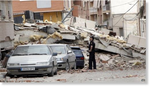
Lorca earthquake 'caused by groundwater extraction'

Image
The relatively modest Magnitude 5.1 quake resulted in extensive damage and nine deaths
Scientists studying the fault beneath the Spanish city of Lorca say that groundwater removal may be implicated in a deadly 2011 earthquake there.

Detailed surface maps from satellite studies allowed them to infer which parts of the ground moved where.

They report in Nature Geoscience that those shifts correlate with locations where water has been drained for years.

The study highlights how human activity such as drainage or borehole drilling can have far-reaching seismic effects.

Bizarro Earth

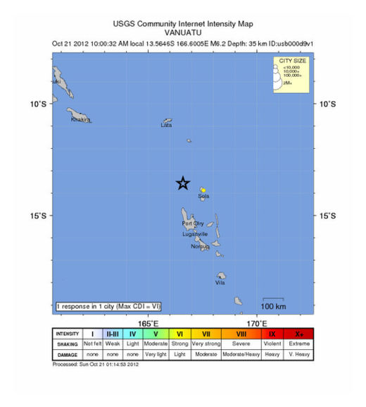
USGS: Earthquake Magnitude 6.2 - WNW of Sola, Vanuatu

Vanuatu Quake_201012
© USGS
Event Time
2012-10-20 23:00:32 UTC
2012-10-21 10:00:32 UTC+11:00 at epicenter

Location
13.565°S 166.601°E depth=35.6km (22.1mi)

Nearby Cities
108km (67mi) WNW of Sola, Vanuatu
226km (140mi) NNW of Luganville, Vanuatu
496km (308mi) NNW of Port-Vila, Vanuatu
816km (507mi) N of We, New Caledonia
857km (533mi) ESE of Honiara, Solomon Islands

Technical Details

Bizarro Earth

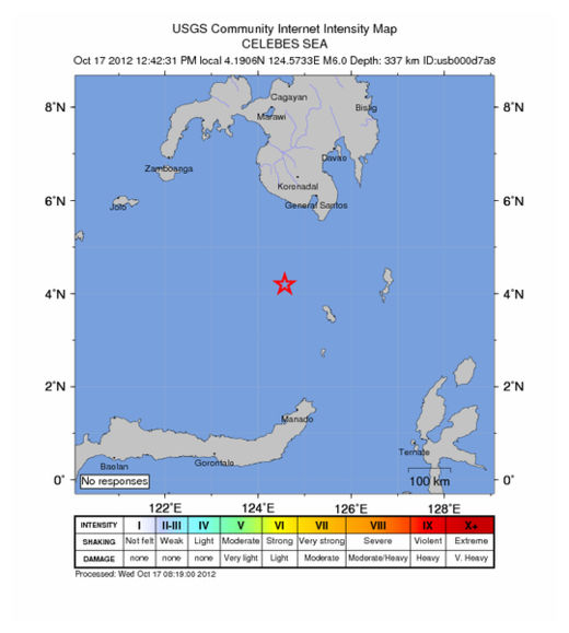
Earthquake Magnitude 6.0 - SW of Sarangani, Philippines

Philippines Quake_171012
© USGS
Event Time
2012-10-17 04:42:31 UTC
2012-10-17 12:42:31 UTC+08:00 at epicenter

Location

4.191°N 124.573°E depth=337.4km (209.7mi)

Nearby Cities
166km (103mi) SW of Sarangani, Philippines
193km (120mi) SSW of Glan, Philippines
199km (124mi) S of Kiamba, Philippines
212km (132mi) SSW of Malapatan, Philippines
1071km (665mi) E of Bandar Seri Begawan, Brunei

Technical Details

Bizarro Earth

Earthquake Magnitude 4.0 - 6km NNE of Waterboro, Maine

Image
© USGS
Event Time
2012-10-16 19:12:22 UTC-04:00 at epicenter
2012-10-16 16:12:22 UTC-07:00 system time

Location
43.592°N 70.676°W depth=6.6km (4.1mi)

Nearby Cities
6km (4mi) NNE of Waterboro, Maine
21km (13mi) WNW of Biddeford, Maine
21km (13mi) WNW of Saco, Maine
23km (14mi) W of West Scarborough, Maine
81km (50mi) ENE of Concord, New Hampshire

Bizarro Earth

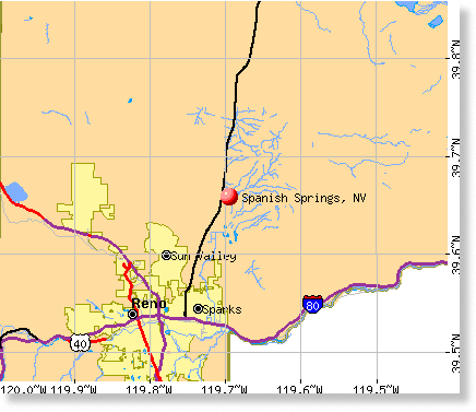
"Hundreds" of earthquakes swarm near Reno, Nevada, as schools practice 'shakeout'

Image
© USGS
University of Nevada, Reno seismologists have reported 115 small earthquakes in the Spanish Springs area since Oct. 8. It's the largest reported batch of earthquakes in a related location near Reno since the 2008 earthquakes in Verdi and Mogul, which included a magnitude 5.0 quake, UNR seismologist Diane dePolo said.

Nevada has about 30 to 50 reported earthquakes each day, she said. The Spanish Springs earthquakes have not registered higher than a magnitude 1.0, but that doesn't mean a larger earthquake isn't possible, she said.

To push earthquake preparedness, each Nevada public school is expected to participate at 10:18 a.m. Thursday in the third annual Great Nevada Shakeout, district officials said.

Bizarro Earth

Quake watchers report a small 2.3 magnitude earthquake near Anniston, Alabama

Image
© USGS
A small earthquake shook Anniston and Oxford Monday morning, according to the Center for Earthquake Research and Information and the U.S. Geological Survey. The quake struck about 2 miles east of Oxford and 4 miles southeast of Anniston.

USGS Data

The earthquake was measured as a 2.3 magnitude quake. It occurred approximately .06 miles below Earth's surface, according to CERI. Approximately 1.3 million 2-2.9 magnitude earthquakes strike every year, according to USGS.

As of 1:30 p.m., one person filed a report with the U.S. Geological Survey claiming to have felt the earthquake. The report said the respondent felt the quake 8 miles away from the epicenter.

The largest earthquake in Alabama history was a 5.1 magnitude quake on Oct. 18, 1916, centered in Irondale, Ala.