Earthquakes
S


Bizarro Earth

USGS: Earthquake Magnitude 6.0 - NW of L'Esperance Rock, New Zealand

L'Esperance Rock Quake_120813
© USGS
Event Time
2013-08-12 04:16:46 UTC
2013-08-11 16:16:46 UTC-12:00 at epicenter

Location

30.620°S 179.613°W depth=325.2km (202.1mi)

Nearby Cities
112km (70mi) NW of L'Esperance Rock, New Zealand
800km (497mi) NE of Whangarei, New Zealand
861km (535mi) NE of North Shore, New Zealand
866km (538mi) NE of Auckland, New Zealand
1139km (708mi) SSW of Nuku'alofa, Tonga

Technical Data

Bizarro Earth

USGS: Earthquake Magnitude 6.0 - WNW of Saumlaki, Indonesia

Saumlaki Quake_120813
© USGS
Event Time
2013-08-12 00:53:43 UTC
2013-08-12 09:53:43 UTC+09:00 at epicenter

Location
7.128°S 129.806°E depth=92.7km (57.6mi)

Nearby Cities
189km (117mi) WNW of Saumlaki, Indonesia
363km (226mi) WSW of Tual, Indonesia
420km (261mi) SSE of Ambon, Indonesia
431km (268mi) SSE of Amahai, Indonesia
492km (306mi) ENE of Dili, East Timor

Technical Details

MIB

NSA Data used by IRS, DEA, etc. prosecute Americans


Newspaper

Our Fearless Leader Obama unveils new plan to 'increase transparency' and 'build greater confidence' in government's mass surveillance program

Image
President Barack Obama unveiled new efforts to increase transparency and "build greater confidence" about the government's controversial surveillance efforts, acknowledging that the public's trust has been shaken after former National Security Agency contractor Edward Snowden leaked details about the programs.

"It's not enough for me as president to have confidence in these programs," Obama declared at a White House news conference. "The American people have to have confidence as well."

Among other things, Obama called for the creation of an outside task force to advise his administration on how to balance civil liberties and security issues. He also said he had directed the intelligence community to make public as much information about the spying programs as possible and directed the NSA to create a website that would be a "hub" for that information.

Comment: These "new efforts to increase transparency and build greater confidence" are to be seen in the stunt the US government pulled last week by shutting down its embassies in a swathe of predominantly Muslim countries, massively stepping up its bombing campaigns in several of them, and terrorising its citizens from straying beyond US borders.


Bizarro Earth

Earthquake Magnitude 6.0 - S of Lakatoro, Vanuatu

Lakatoro Quake_060813
© USGS
Event Time
2013-08-06 17:21:58 UTC
2013-08-07 04:21:58 UTC+11:00 at epicenter

Location
16.880°S 167.401°E depth=31.2km (19.4mi)

Nearby Cities
84km (52mi) S of Lakatoro, Vanuatu
136km (85mi) NW of Port-Vila, Vanuatu
151km (94mi) S of Luganville, Vanuatu
447km (278mi) N of We, New Caledonia
591km (367mi) N of Dumbea, New Caledonia

Technical Details

Bizarro Earth

Earthquakes recorded below Mt. Tongariro

Mt.Tongariro
© TVNZ
Mt Tongariro is under a watching brief after a series of small earthquakes was detected under the volcano over the past two weeks.

GNS Science duty volcanologist Michael Rosenberg said the quakes were not connected to the ongoing flurry of seismic activity centred in the Cook Strait and the tremors were no cause for ''undue alarm.''

Fewer than 10 quakes, all under magnitude 1.5, have been recorded on a handful of seismic monitors and are too small to be pinpointed.

''The reason we're paying attention is because of their location and we don't see quakes there very often,'' Rosenberg said.

The volcano erupted for the first time in a century at the Te Maari craters in August last year, followed by another eruption in November and scientists warn the craters could still erupt with little or no warning.

Bizarro Earth

USGS: Earthquake Magnitude 6.2 - NE of Bristol Island, South Sandwich Islands

Bristol Quake_260713
© USGS
Event Time
2013-07-26 21:32:59 UTC
2013-07-26 19:32:59 UTC-02:00 at epicenter

Location
57.789°S 23.959°W depth=10.0km (6.2mi)

Nearby Cities
203km (126mi) NE of Bristol Island, South Sandwich Islands
2715km (1687mi) ESE of Ushuaia, Argentina
2937km (1825mi) ESE of Rio Gallegos, Argentina
2952km (1834mi) ESE of Punta Arenas, Chile
2258km (1403mi) ESE of Stanley, Falkland Islands

Technical Details

Bizarro Earth

USGS: Earthquake Magnitude 6.2 - ENE of Luganville, Vanuatu

Luganville Quake_260713
© USGS
Event Time
2013-07-26 07:07:17 UTC
2013-07-26 18:07:17 UTC+11:00 at epicenter

Location
15.362°S 167.584°E depth=135.5km (84.2mi)

Nearby Cities
48km (30mi) ENE of Luganville, Vanuatu
274km (170mi) NNW of Port-Vila, Vanuatu
615km (382mi) N of We, New Caledonia
760km (472mi) N of Dumbea, New Caledonia
760km (472mi) N of Paita, New Caledonia

Technical Details

Bizarro Earth

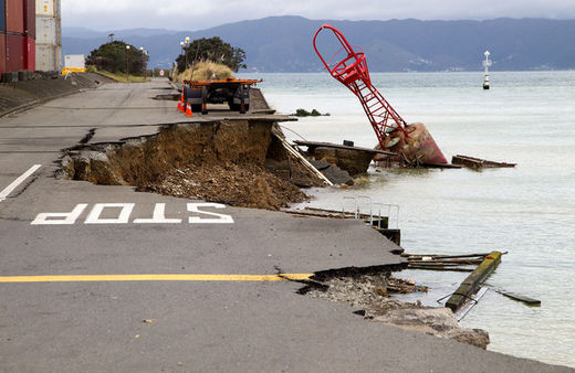
Third major earthquake strikes New Zealand in three days: Latest 6.5 magnitude quake sends Kiwis screaming from Wellington buildings as port partially falls into sea

Image
© Marty Melville/AFP/Getty ImagesA bout that used to be on the edge of the road sits in the harbour where the land fell into the sea at the Port Wellington Container terminal caused by yesterday's earthquake on July 22, 2013.
New Zealanders ran screaming from buildings in Wellington yesterday as a magnitude 6.5 earthquake blew out windows and caused part of the city's port to slide into the sea.

The earthquake struck at 5:09 p.m. local time and was centered offshore, 57 kilometers (35 miles) south-southwest of the capital city, at a depth of 14 kilometers, according to the U.S. Geological Survey. It was New Zealand's biggest quake since a magnitude 6.3 killed 185 people in the South Island city of Christchurch two years ago, and the strongest to hit the central region of the country since 1942, GNS Science seismologist John Ristau said.

There is an 8 percent chance of another magnitude 6 event or larger in the next 24 hours, and 20 percent over the next seven days, Ristau said in a telephone interview. "A large earthquake can increase stress or decrease stress on neighboring faults, that's what we're looking closely at," he said.

Bizarro Earth

USGS: Earthquake Magnitude 6.1 - WNW of Marion Island, Prince Edward Islands

Marion Islands Quake_220713
© USGS
Event Time
2013-07-22 07:01:42 UTC
2013-07-22 09:01:42 UTC+02:00 at epicenter

Location
46.042°S 34.825°E depth=10.0km (6.2mi)

Nearby Cities
244km (152mi) WNW of Marion Island, Prince Edward Islands
1538km (956mi) SSE of Port Alfred, South Africa
1558km (968mi) SSE of Port Elizabeth, South Africa
1562km (971mi) SSE of East London, South Africa
1963km (1220mi) SSE of Maseru, Lesotho

Technical Details