Earthquakes
S


Bizarro Earth

USGS: Earthquake Magnitude 7.3 - 10km WNW of Isnos, Colombia

Image
© USGS
Event Time:

2012-09-30 16:31:35 UTC
2012-09-30 11:31:35 UTC-05:00 at epicenter
2012-09-30 09:31:35 UTC-07:00 system time

Location:

1.972°N 76.329°W depth=162.1km (100.7mi)

Nearby Cities:

10km (6mi) WNW of Isnos, Colombia
34km (21mi) WNW of Pitalito, Colombia
60km (37mi) SSE of Popayan, Colombia
67km (42mi) SW of La Plata, Colombia
344km (214mi) NE of Quito, Ecuador

Radar

Huge Earthquake Triggered Other Quakes Worldwide

Image
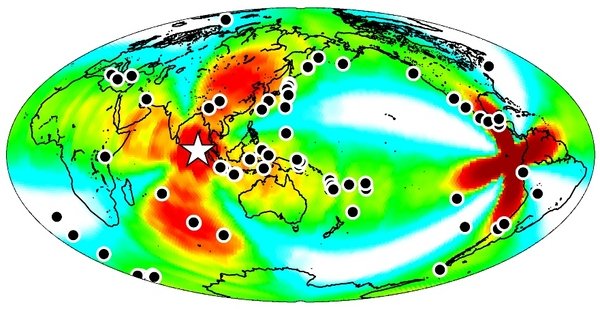
© LiveScience.com/Fred Pollitz, USGS A map of the earthquakes triggered around the globe (shown as black dots) within a week of the April 11, 2012 earthquake off the coast of Sumatra
On April 11, a massive magnitude 8.6 earthquake shook the floor of the Indian Ocean off Sumatra. It wasn't just unusual because of its size - the 10th largest quake in the last century - it also set off a series of quakes around the world for up to six days afterward, according to a study published today (Sept. 26) in the journal Nature.

"Until now, we seismologists have always said, 'Don't worry about distant earthquakes triggering local quakes,'" said Roland Burgmann, an earth and planetary scientist at UC Berkeley, in a statement. "This study now says that, while it is very rare - it may only happen every few decades - it is a real possibility if the right kind of earthquake happens."

The study found that some quakes were triggered within a few hours, while in other places the seismic waves from the Sumatran quake primed temblors to happen for up to six days later.

The findings should remind those living in seismically active areas that the risk from a large earthquake could persist, even on the opposite side of the globe, for more than a few hours, the study scientists said.

Another study also published today suggests that the quake marks the birth of a new tectonic plate beneath the Indian Ocean.

Bizarro Earth

USGS: Earthquake Magnitude 6.9 - 33km S of Tanaga Volcano, Alaska

Image
© USGS
Event Time:

2012-09-26 23:39:58 UTC
2012-09-26 14:39:58 UTC-09:00 at epicenter
2012-09-26 16:39:58 UTC-07:00 system time

Location:

51.583°N 178.200°W depth=40.5km (25.2mi)

Nearby Cities:

33km (21mi) S of Tanaga Volcano, Alaska
1487km (924mi) SSE of Anadyr', Russia
1580km (982mi) E of Petropavlovsk-Kamchatskiy, Russia
1597km (992mi) E of Yelizovo, Russia
2806km (1744mi) W of Whitehorse, Canada

Bizarro Earth

Weird 2012 Quake Signals Tectonic Plate Birth

Sumatra Earthquake
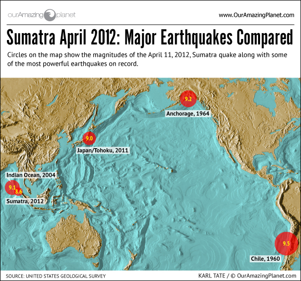
© OurAmazingPlanetThe earthquake that struck Sumatra was a big one. Here's how it compares to some record holders.
On the afternoon of April 11, 2012, one of the most powerful earthquakes ever recorded - and now revealed to be among the weirdest - struck in the Indian Ocean, off the coast of Sumatra. It's a region all too familiar with geological catastrophe.

Eight years earlier, in December 2004, the third largest earthquake on record had ripped through a nearby region of the ocean floor. The magnitude-9.1 earthquake and the monstrous tsunami that soon followed killed more than 227,000 people in 14 countries,

So when a magnitude-8.7 earthquake (some put the magnitude at 8.6) shook the Indonesian island on that Wednesday afternoon earlier this year, many expected the worst. Yet, no monster wave appeared. A wave did come ashore, but it was a miniature tsunami, just 12 inches (31 centimeters) high.

All told, the earthquake did very little damage - yet only five higher earthquake magnitudes have ever been recorded. So what was the deal?

New research published today (Sept. 26) in the journal Nature delves into the intimate details of this earthquake, along with the powerful, magnitude-8.2 quake that followed two hours later. The new studies add to an existing body of research that shows this was a remarkable event - one of the most surprising earthquakes ever recorded - and one that offers an unlikely snapshot of a geological process millions of years in the making.
Bizarro Earth

USGS: Earthquake Magnitude 6.2 - NNE of La Paz, Mexico

LaPaz Quake_250912
© USGS
Event Time
2012-09-25 23:45:26 UTC
2012-09-25 16:45:26 UTC-07:00 at epicenter

Nearby Cities
75km (47mi) NNE of La Paz, Mexico
154km (96mi) E of Ciudad Constitucion, Mexico
154km (96mi) SW of Ahome, Mexico
157km (98mi) SW of Los Mochis, Mexico
972km (604mi) SSE of Phoenix, Arizona

Technical Details

Bizarro Earth

Another Earthquake Swarm - Virgin Islands, Magnitude 3.6 - 119km N of Road Town, British Virgin Islands

Image
© USGS
Event Time

2012-09-23 19:44:46 UTC
2012-09-23 15:44:46 UTC-04:00 at epicenter
2012-09-23 12:44:46 UTC-07:00 system time

Nearby Cities


119km (74mi) N of Road Town, British Virgin Islands
132km (82mi) NNE of Charlotte Amalie, U.S. Virgin Islands
170km (106mi) NE of Fajardo, Puerto Rico
179km (111mi) NE of Rio Grande, Puerto Rico
189km (117mi) NE of Carolina, Puerto Rico

Swarm Data

Bizarro Earth

USGS: Earthquake Magnitude 6.0 - 55km SSW of Larsen Bay, Alaska

Image
© USGS
Event Time
2012-09-18 01:44:47 UTC
2012-09-17 17:44:47 UTC-08:00 at epicenter
2012-09-17 18:44:47 UTC-07:00 system time

Nearby Cities
55km (34mi) SSW of Larsen Bay, Alaska
525km (326mi) SSW of Anchorage, Alaska
561km (349mi) SSW of Knik-Fairview, Alaska
934km (580mi) SSW of Fairbanks, Alaska
1174km (729mi) WSW of Whitehorse, Canada

Bizarro Earth

USGS: Earthquake Magnitude 6.2 - SSW of Sungai Penuh, Indonesia

Indon Quake_140912
© USGS
Event Time
2012-09-14 04:51:47 UTC
2012-09-14 11:51:47 UTC+07:00 at epicenter

Nearby Cities

166km (103mi) SSW of Sungaipenuh, Indonesia
192km (119mi) WNW of Bengkulu, Indonesia
216km (134mi) W of Curup, Indonesia
253km (157mi) W of Lubuklinggau, Indonesia
629km (391mi) SW of Singapore, Singapore

Bizarro Earth

USGS: Earthquake Magnitude 5.1 - 14km W of Ashkasham, Afghanistan

Image
© USGS
Event Time
2012-09-12 19:29:55 UTC
2012-09-12 23:59:55 UTC+04:30 at epicenter
2012-09-12 12:29:55 UTC-07:00 system time

Nearby Cities
1km (9mi) W of Ashkasham, Afghanistan
22km (14mi) W of Ishkashim, Tajikistan
51km (32mi) ESE of Jarm, Afghanistan
84km (52mi) SE of Fayzabad, Afghanistan
307km (191mi) SE of Dushanbe, Tajikistan

Bizarro Earth

Costa Rican Officials: A Strong Earthquake Could Still Occur in Guanacaste

Experts confirmed the Sept. 5 magnitude-7.6 earthquake was the 'Big One' they've been expecting, but the fault rupture was only of 50 percent.

After a series of analyses conducted in the northwestern province of Guanacaste, experts from the Volcanological and Seismological Observatory of Costa Rica (Ovsicori) reported Tuesday that another quake of equal or greater magnitude could occur in Nicoya Peninsula, but predicting when it would happen is "impossible ."

Marino Protti, Ovsicori's lead scientist, explained that the magintude-7.6 earthquake on Sept. 5 caused a 40 percent slip and an inclination of 1.8 meters on the fault located in Nicoya.

He also said that although the quake was the "big one" experts had been expecting for Guanacaste, the fault ruptured by only 50 percent, meaning that the possibility that another earthquake of equal or greater magnitude in the area still remains.

Ovsicori's report, released Tuesday, also stated that the earthquake triggered the activation of three faults in Aguas Zarcas (in the northern region), the Guanacaste Volcanic Area and Irazú Volcano (north of Cartago). Seismologists will continue monitoring the areas.

By Tuesday morning, the total count of aftershocks from the recent earthquake was 1,650. On Sept. 5 at 8:42 a.m., the 7.6-magnitude earthquake shook the country and was felt as far away as Nicaraguan and Panama. Its epicenter was located 20 kilometers northwest of Sámara in the Nicoya Península.