Earth ChangesS


Arrow Down

US, Connecticut: SUV Lands in Sinkhole

Sinkhole on West Raymond Street caused by water main break
Image
© unknown
A water main break on West Raymond Street in Hartford not only closed down the street but it also caused some problems for an SUV and its driver.

Willena Hardie's husband was backing out of their driveway when one of the front tires fell into a sinkhole.

"He was banged around and so frazzled, so he called me and that's what I found when I got here," she said.

Attention

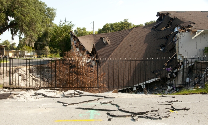
US, Florida: Sinkhole Eats Local Business

Image
© unknownThe roof of Main Street Hair & Beauty Supply has caved in on Friday, July 22, 2011, in Leesburg.
The roof of a Leesburg business building has collapsed, weeks after a sinkhole gulped part of it.

As the roof of the Main Street Hair and Beauty Supply of Saaraa Corner Store crumpled, more debris, including a Dumpster, trees, boxes and beauty products, was pushed into the sinkhole.

However, city officials are adamant that the sinkhole is not growing, and attribute the collapse instead to the building's wooden trusses that gave way.

"There's no indication that it's growing," said Robert Sargent, a spokesman for the city of Leesburg, adding that soil around the edges of the hole also has fallen in.

The discovery of the sinkhole came on the early morning of June 27, when Rafeek Mohamid, owner of the property, received a call from his alarm company that something was wrong.

Nuke

Threat to Japan's Food Chain Multiplies as Radiation Spreads

Packs of beef
© Tomohiro Ohsumi/BloombergPacks of beef are displayed for sale in a supermarket in Fukushima prefecture, Japan.
Radiation threats to Japan's food chain are multiplying as cesium emissions from the crippled Fukushima Dai-Ichi nuclear power plant spread more widely, moving from hay to cattle to beef.

Hay contaminated with as much as 690,000 becquerels a kilogram, compared with a government safety standard of 300 becquerels, has been fed to cattle. Beef with unsafe levels of the radioactive element was detected in four prefectures, the health ministry said July 23.

Agriculture Minister Michihiko Kano has said officials were unaware of the risk that rice farmers might ship tainted hay to cattle growers. That highlights the government's inability to think ahead and to act, said Mariko Sano, secretary general for Shufuren, a housewives organization in Tokyo.

"The government is so slow to move," Sano said. "They've done little to ensure food safety."

Radar

US, California: Small earthquake hits Los Angeles area; no damage

A small earthquake has hit the Los Angeles area, but there have been no reports of damage.

The U.S. Geological Survey says the magnitude-3.3 temblor struck just after midnight Saturday. It hit 13 miles south of the Los Angeles Civic Center at a depth of about 10 miles.

Matt Spence with the Los Angeles Fire Department says no injuries or damages have been reported.

Source: The Associated Press

Arrow Up

Australia: Freak weather forces waterfall to flow UPWARDS in extreme 75mph winds

Extreme weather has been battering Australia this week.

Winds have become so strong that waterfalls have been blown upwards.

The strong winds, which are seriously affecting the waterways of southern Australia, have gone up to 75mph.

Image
© BBCExtreme: Winds in southern Australia are so strong that even waterfalls have been affected
Earlier this week, Sydney saw a month's worth of rain falling in just one day, according to the BBC.

Although the ferries which hundreds of commuters rely on have kept running, they have provided rocky rides for those brave enough to keep travelling on them.

Bizarro Earth

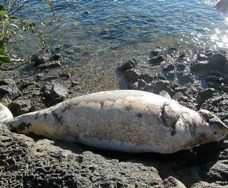
Australia: Another dugong death

dudong
© ContributedThis dead dugong was found on Witt Island by Clive Last, who is increasing worried by marine animal deaths in Gladstone Harbour

Another dead dugong has been found in Gladstone Harbour, and the man who found it wants some answers.

Clive Last, who in May discovered a dead dolphin on Turtle Island, was shocked on Friday afternoon when he found the body of a dead dugong on Witt Island.

Mr Last is wary of suggestions marine animal deaths this year can be attributed to boat strikes and net fishing. He said those explanations didn't match his observations on the harbour.

Bizarro Earth

Japan: Earthquake Magnitude 6.2 - Near the East Coast of Honshu

Honshu Quake_240711
© USGSEarthquake Location
Date-Time:
Sunday, July 24, 2011 at 18:51:25 UTC

Monday, July 25, 2011 at 03:51:25 AM at epicenter

Location:
37.758°N, 141.540°E

Depth:
35.6 km (22.1 miles)

Region
NEAR THE EAST COAST OF HONSHU, JAPAN

Distances:
79 km (49 miles) SE (133°) from Sendai, Honshu, Japan

94 km (59 miles) E (88°) from Fukushima, Honshu, Japan

95 km (59 miles) NE (36°) from Iwaki, Honshu, Japan

282 km (175 miles) NE (34°) from TOKYO, Japan

Bizarro Earth

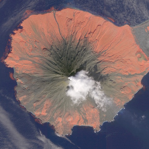
Alaskan Volcano Eruption Warning Threatening Air Travel

Cleveland Volcano
© GeoEye 2010This GeoEye IKONOS image shows a faint plume issuing from Cleveland Volcano at 2:31 PM on September 14, 2010. Red in this image highlights areas of vegetation detected by the near-infrared channel.

The Alaska Volcano Observatory has issued an eruption advisory for a remote volcano in the Aleutian Islands which, according to various media reports, lies underneath a major American flight route.

According to the Daily Mail, the volcano in question--5,676-foot tall Mount Cleveland (also known as Cleveland Volcano) on the western end of the island of Chuhinadak--"could be poised for its first big eruption in ten years," which has experts anticipating that "it could erupt at any moment, spewing ash clouds up to 20,000 feet above sea level with little further warning."

Yereth Rosen of Reuters reports that "thermal anomalies" had been detected via satellite on Thursday, and that the volcano, which is located approximately 940 miles southwest of Anchorage, "could erupt with little further warning."

"A major eruption could disrupt international air travel because Cleveland Volcano, like others in the Aleutians, lies directly below the commercial airline flight path between North America and Asia, said John Power, scientist-in-charge at the Alaska Volcano Observatory," Rosen added.

Camera

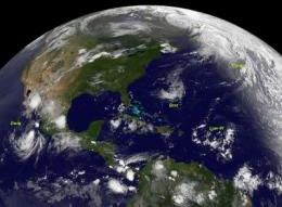
NASA catches 3 tropical cyclones at 1 time

Nasa captures 3 cyclones
© NASA/NOAAIn this infrared image from the GOES-13 satellite on July 22 at 0845 UTC (4:45 a.m. EDT) Bret and Cindy are in the Atlantic, Low#1 (from a tropical wave) is in the Caribbean and Hurricane Dora is in the eastern Pacific, off the coast of Mexico.
It's not often that a satellite can capture an image of more than one tropical cyclone, but the GOES-13 satellite managed to get 3 tropical cyclones in two ocean basins in one image today. Bret and his "sister" Cindy are racing through the North Atlantic, while another area tries to develop far to their south. "Cousin" Dora is still a hurricane in the eastern Pacific.

An infrared image taken on July 22 at 0845 UTC (4:45 a.m. EDT), GOES-13 captured Tropical Depression Bret, Tropical Storm Cindy in the north Atlantic and low pressure area associated with a tropical wave in the Caribbean and Hurricane Dora is in the eastern Pacific, off the coast of Mexico. Cindy is 910 miles west-northwest of the Azores and Bret 295 miles northwest of Bermuda.

NASA's GOES Project issued an infrared image of both Bret and Cindy today from the GOES-13 satellite, which is operated by NOAA. The NASA GOES Project is housed at NASA's Goddard Space Flight Center in Greenbelt, Md. and uses GOES-13 data from NOAA to create images and animations.

Bret Being Battered

During the morning of July 22 Bret has sped up on his track through the north Atlantic and weakened. Bret is being battered by winds and cooler waters.

Bret was a tropical depression at 8 a.m. EDT on July 22, with maximum sustained winds near 35 mph (55 kmh). He was speeding to the northeast near 21 mph (33 kmh). By noon (EDT) Bret had degenerated into a low pressure area. His center was near 37.7N and 64.2 W, about 375 miles north of Bermuda.

Stop

Canada: Mud, rocks, trees slide onto Trans-Canada in British Columbia closing road for days

A large mudslide has closed the Trans-Canada Highway between Lake Louise, Alta. and Golden, B.C.

Parks Canada spokesman Mark Merchant says mud, rock and large trees poured onto the highway late Friday night near the spot where the road overlooks the Spiral Tunnels on the Canadian Pacific Railway.

Merchant says no one was injured, but provincial officials in B.C. say the highway will likely remain closed until Sunday afternoon.

He says the slide likely occurred because the area has received a lot of rain lately.

Traffic is being detoured south on Highway 93, which has reopened after being closed Friday due to a fatal crash that involved a fuel tanker.

Last month, a woman was injured when her car was caught in a mudslide on the Trans-Canada between Hope and Chilliwack.