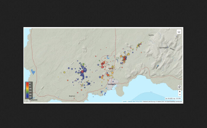
It is important to note that seismic activity is will likely continue northwest of Þorbjörn, and earthquakes over M4.0 could be found in populated areas. Triggered seismic activity can also be expected in the coming days because the magma intrusion causes increased tension in the area. Rockfall can occur following strong earthquakes, so it is important to be cautious on steep slopes.
Reviewed earthquakes from midnight November 1st until noon November 2nd.
Updated 1. November at 12:20pm
On 25 October, an intense earthquake swarm began near Svartsengi, north of Grindavík on the Reykjanes Peninsula. So far, over 10,500 earthquakes have been detected in the swarm, with over 26 earthquakes exceeding magnitude three, the largest of which was magnitude 4.5 on 25 October at 08:18 UTC.
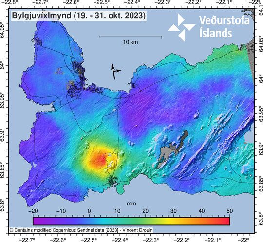
The latest satellite radar image, acquired late on 31 October, reveals 5 to 6 cm of ground movements over 12 days, centered just northwest of Mt. Þorbjörn. The same displacement signal is seen in continuous GPS measurements from stations in the region, beginning on 27 October. The latest GPS results from 1 November indicate that ground displacements continue in the region. Combining seismic, geodetic, and satellite-based observations, we infer that a volcanic intrusion is located at about 4 km depth just northwest of Mt. Þorbjörn. Presently, there are no indications that the volcanic intrusion is becoming shallower. We expect that seismicity will continue northwest of Mt. Þorbjörn, and this could include felt earthquakes exceeding magnitude four. Triggered earthquake activity is also possible in the coming days due to stress increases caused by the intrusion. This is a likely explanation for the ongoing seismic activity detected west of Þorbjörn in Eldvörp on 1 November. Triggered seismicity is also possible due to the long-term effects of magma accumulation beneath Fagradalsfjall.

This morning at 8:40 am an earthquake swarm began at Þorbjörn, which lasted for almost 2 hours and was exceptionally intense. The largest earthquake in the swarm measured M3.7. The center of the activity was just east of the centre of the uplift observed in recent days. The depth of the earthquakes was estimated between 5 and 1.5 km depth. The earthquake swarm is a clear sign of magma movements at depth. GPS measurements support the interpretation, although the uplift that started about four days ago has slowed down. Earlier today, there was a meeting with Civil Defense and stakeholders on the Reykjanes Peninsula, where the latest measurements and possible scenarios and responses to the current scenario were discussed.
Situation closely monitored
IMO is monitoring closely developments and is looking to see if micro-seismic activity increases closer to the surface, which could be a sign that magma is breaking its way through the earth´s crust. Presently, there are no signs that earthquake activity is becoming shallower. However, the situation could change quickly, and it is not possible to exclude a scenario involving a lava-producing eruption in the area northwest of Þorbjörn. It is important to point out that magma movements, similar to that observed close to Þorbjörn, often fade away and do not lead to a volcanic eruption. Nevertheless, long-term rifting and increased (triggered) earthquake activity in the Svartsengi area could have created weaknesses in the crust, making it easier for magma to move to shallower depths.
Reviewed earthquakes from midnight today.


Comment: Oppenheimer Ranch are providing regular reports on the uptick in Iceland, and elsewhere:
See also: Ground uplift continues at Thorbjorn Complex, volcano-tectonic unrest affecting wide area of Reykjanes Peninsula, Iceland