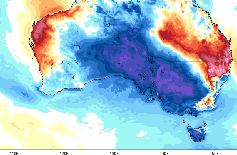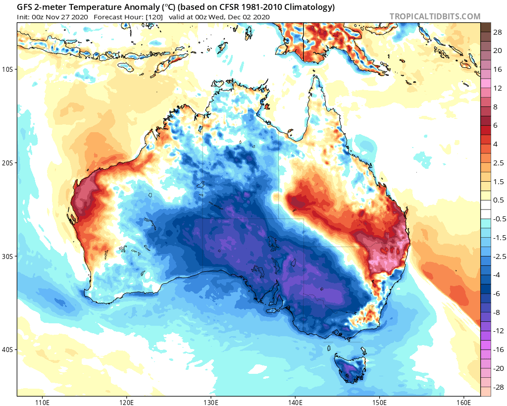
© electroverse.netGFS 2m Temp Anomalies (C) for Dec 2.
The MSM is using images of last year's wildfires in the hope that their readers are too trusting and/or stupid (or perhaps too busy) to do their own research.
Chief warm-mongers,
The Guardian are
warning that Friday's temperatures will lead to heat-related illness such as dizziness, tiredness, irritability, shallow breathing, vomiting and confusion.
However, one quick check of the weather charts reveals the only vomit-inducing and confusing things here are the MSM's bias reporting, not the mercury: 1) 30C to 40C is hardly unprecedented at this time of year, and 2) the heat is also very fleeting, running from the evening of Nov 26 and concluding, for most, on Nov 28.
Moreover, the balmy temps will be replaced by
record polar cold as the calendar flips to December (a setup serving as yet another example of the prevalence of
swing between extremes during times of low solar activity).
Both the
GFS and
ECMWF are currently in alignment here, with each weather model foreseeing Antarctic air sweeping in from the west on Tuesday and engulfing central and southern regions by Wednesday:

GFS 2m Temp Anomalies (C) for Dec 2.
The picture turns a little uncertain after that, but by then the higher elevations of Tasmania are forecast to have received a rare dumping of summer snow, perhaps as much as
2.2 inches (5.9 cm):
![Click to enlarge ECMWF “new snow” forecast for Dec 1 [windy.com].](/image/s29/590973/Tas_Snow_Dec_crop.png)
© windy.comECMWF “new snow” forecast for Dec 1
![Click to enlarge GFS “total snowfall” for Dec 1 [tropicaltidbits.com].](/image/s29/590974/Dec_1_snow_crop.jpg)
© tropicaltidbits.comGFS “total snowfall” for Dec 1
Eyeing east and across the Tasman sea,
New Zealand's South Island is on for some truly astonishing December totals by the end of next week.
The cold air mass that engulfed southern Australia at the start of the week is set to deliver bone-chilling lows and up to
31.8 inches (80.8 cm) of summer snow down the western mountain ranges:
![Click to enlarge ECMWF “new snow” forecast from Nov 27 to Dec 6 [windy.com].](/image/s29/590975/NZ_snow_dec_crop.jpg)
© windy.comECMWF “new snow” forecast from Nov 27 to Dec 6
These dumpings could threaten all-time December snowfall records.
Stay tuned for updates.
Winter 2020 was a relatively mild one across New Zealand, but with the arrival of spring came a violent switch in fortunes.
September 1 saw widespread snowfall across the South Island with accumulations building at abnormally low-levels: inland parts of
Canterbury and Otago, for example,
saw5+cm (2+inches)The cold and snowy conditions lingered through September, and conspired to deliver
1.3 feet of spring snow to the nation's ski-fields
mid-monthThe
COLD TIMES are returning, the mid-latitudes are
REFREEZING in line with
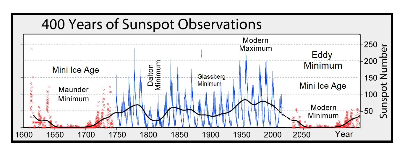
historically low solar activity,
cloud-nucleating Cosmic Rays, and a
meridional jet stream flow.
Both NOAA and NASA appear to agree,
if you read between the lines, with NOAA saying we're entering a
'full-blown' Grand Solar Minimum in the late-2020s, and NASA seeing this upcoming solar cycle
(25) as "
the weakest of the past 200 years", with the agency correlating previous solar shutdowns to prolonged periods of global cooling
here.
Furthermore, we can't ignore the slew of new scientific papers stating the immense impact
The Beaufort Gyre could have on the Gulf Stream, and therefore the climate overall.

© electroverse.net400 Years of Sunspot Observations
—
learn the facts, relocate if need be, and grow your own.
Consider the following quote from Buddhist Monk and Philosopher Thich Nacht Han, he said this; “In order to rally populations governments need enemies. They want us to be afraid so we will rally behind them. And if they do not have a real enemy, they will invent one in order to mobilize us.” I’ll leave it up to the listener to plug that principle into the equation that’s occupying the full attention of global populations at this moment in time.
But while doing so consider this statement from George Orwell, quote; “The war is not meant to be won, it’s meant to be continuous.” Now, can a slight alteration of this profound statement from Orwell provide even more meaning? An example, quote; “the disease is not meant to be cured, it’s meant to be continuous.”
So many verifiable facts on CV-19 and looming existential environmental challenges are not being addressed in any way, shape, or form by any official sources or power structured controlled mainstream media. If there is any chance of exposing the insanity and changing course it’s up to us. Normalcy bias, confirmation bias, and cognitive dissonance within too much of the population, these are conditions that are completely connected to the circus of insanity we find ourselves caught up in at this moment…”-Dane Wigington Geoengineering Watch Global Alert News, November 28, 2020 #277 [Link]