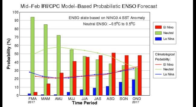
© International Research Institute for Climate and SocietyThe chance for various phases of El Niño.
In a statement on Feb. 9, the Climate Prediction Center announced the end of La Niña, the counterpart to El Niño that changes global weather patterns. These oscillations occur naturally with periods of 2 to 7 years with varying predictable effects around the globe - including hurricane activity.
With La Niña's end, sea temperatures have steadily warmed in the equatorial region of the central and eastern Pacific, and we're now in the neutral phase of the oscillation. As shown below, models currently suggest we'll be in the neutral category through the spring and into the summer months (June-July-August, or JJA),
but after that, sea temperatures could be warm enough for El Niño conditions to take over.
In the heart of hurricane season - August, September and October (ASO) -
the chance for El Niño climbs over 50 percent, according to the International Research Institute for Climate and Society (IRI) forecast. NOAA-CPC also forecasts about a
50 percent chance of El Niño developing sometime September through November.
However, El Niño/La Niña model forecasts this time of year are very uncertain, as
NOAA-CPC cautioned in a blog. That is because spring is a transitional time of year, which makes it difficult to forecast a change to a new phase.
El Niño is defined as a season-long, or longer, warming of the eastern central Pacific waters close to the Equator by at least 0.5 degrees Celsius. La Niña, and its counterpart warm phase El Niño, sometimes have major effects on the Atlantic hurricane season.
These effects are generally predictable, but not all El Niños are created equal, especially when it comes to the atmosphere. El Niño, as mentioned before, is actually a change in the ocean, not a straightforward atmospheric phenomenon.
The ocean and our atmosphere respond to each other in a loose relationship, and that relationship can result in slightly different effects from one El Niño to the next. For example, last year's strong El Niño failed to result in significant rainfall across Southern California, where it's typically expected in the winter during that phase.
History tells us that most El Niños inhibit hurricane growth through a couple of different ways.
Due to the warmer waters in the eastern Pacific, air rises above that water just like it would over a warm bowl of soup. That air cannot just go out to space. "What goes up must come back down" is a good way to explain what happens in parts of the Caribbean and western Atlantic. That air cools and descends on the northern side of Central America, stunting thunderstorm growth and stabilizing the weather in the region.
The winds that cross Central America are faster than they would be without El Niño. This enhanced wind takes the tops of the tropical clouds eastward faster than at the surface, which limits vertical thunderstorm growth.
The low-level trade winds are also enhanced. These winds blow toward the west, pushing showers and storms westward faster than usual. This, combined with enhanced upper-level winds, tilts storms eastward, further hampering storm growth.
These effects aggregate into a less-active hurricane season, but this is what typically occurs, rather than a hard rule.
It's too early to know whether the latter half of the 2017 hurricane season will be impacted by any developing El Niño. After all, odds are still 50/50 as to whether it will develop or not.
Also unknown is how much of the aforementioned atmospheric response would occur before the end of the season even if El Niño did develop. In the months ahead, we should have a clearer picture of the ultimate outcome.
Hurricane season in the Atlantic Basin runs from June 1 to Nov. 30, but tropical cyclones - including hurricanes and tropical storms - can occur any time of the year.
Reader Comments
to our Newsletter