© AccuWeather
With the first day of spring ending up colder than Christmas Day, the stage is set for disruptive snow to ride up the coast of the northeastern United States Sunday evening into Monday.
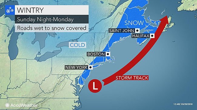
After wet snow in the mid-Atlantic struggles to stick to roads, the threat of snow-covered roads will heighten Sunday evening into Monday as an offshore storm begins to strengthen and cause moderate to heavy snow along the Northeast coast.
As the snow along the coast unfolds Sunday evening, a couple of inches of snow will create slick spots in the southern Appalachian Mountains.
The snow will increase as it
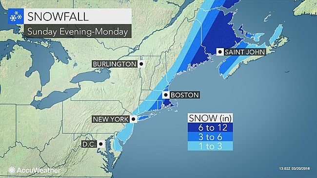
spreads up the Northeast coast, leading to totals of around an inch on grassy surfaces in Delaware to
travel-disrupting amounts approaching or exceeding six inches in eastern Long Island and far eastern New England.
The heaviest amounts will be measured on grassy and elevated surfaces, but motorists should prepare for roads to still become slick. This includes in Islip and Montauk, New York; Providence, Rhode Island;
Boston and Plymouth, Massachusetts; and Portland and Bangor, Maine.
In Boston, snow totals will be greatest toward the South Shore with less in the northern and western suburbs.
"When temperatures fall after sunset, bridges and overpasses will be the first surfaces to see snow accumulate, which may sneak up on drivers experiencing otherwise wet roads," AccuWeather Meteorologist Brian Thompson said.
AccuWeather Meteorologist Jim Andrews also warned of persistently shaded areas being among the first surfaces to turn slick.
There could be enough of a gusty wind to blow the snow around, further reducing visibility.
Residents should prepare for a slow morning commute with slippery roads and flight delays in eastern New England on Monday. NCAA basketball fans heading to watch the women's second round games in Storrs, Connecticut, could face travel difficulties Monday morning.
"[The snow] may also cling to and weigh down some tree limbs," AccuWeather Senior Meteorologist Alex Sosnowski said. "A few sporadic power outages are possible as a result."
Southeastern Massachusetts is at greatest risk for this threat.

© AccuWeather
The storm will also track close enough to the coast for snow to graze the major urban areas of Philadelphia and New York City Sunday night.
Roads will mainly be wet in Center City Philadelphia, but will turn slushy in any heavier bursts of snow in New York City, its suburbs and New Jersey.
The snow will have cleared New York City, Philadelphia and the rest of the mid-Atlantic by Monday morning.
"With temperatures near or just above freezing Monday morning after the snow ends, travel conditions should improve pretty rapidly from New Jersey and the New York City area into southern Connecticut," Thompson said.
There may still be flight delays at the New York City airports early as crew clear the runways. While any lingering snow will quickly melt later in the day, airline passengers may still encounter delays due to the ripple effect of problems in Boston and elsewhere in eastern New England.
Snow will depart New England in a south-to-north fashion Monday into Monday evening. Outside of Maine, the snow will begin to melt soon after it ends.
However, any wet or slushy areas will freeze and turn icy on untreated surfaces Monday night as temperatures plummet below freezing.
Setting the stage for the snow to start spring in the Northeast is the cold air that is causing the official first day of spring to be colder than Christmas Day, even in areas that will miss out on any snowfall.
Brisk winds will allow the chill to linger in the Northeast on Monday before warmer air makes a comeback as the week progresses. However, snow could streak back into northern New England at midweek before the springlike warmth returns.
Reader Comments
to our Newsletter