On March 20, a flood warning was in effect up and down the eastern sides of Texas and Oklahoma, including Dallas and Fort Worth, Texas. The National Weather Service posted a flood warning for the double cities because of heavy rainfall over the last 36 hours. More isolated thunderstorms are expected to develop late afternoon and evening, generating more heavy rainfall, lightning and small hail.

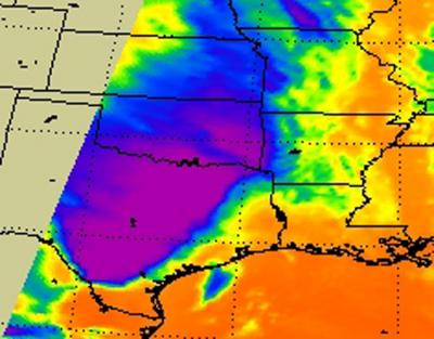
When NASA's Aqua satellite flew over the low pressure area on March 20 at 0753 UTC 34:53 a.m. EST), the Atmospheric Infrared Sounder (AIRS) instrument onboard captured an infrared image that showed cloud top temperatures in the frontal system. The strongest thunderstorms, heaviest rainfall and coldest cloud top temperatures (around 220 Kelvin/ -63.6 F/-53.1 C) appeared as a giant wedge over the region.
NASA's Goddard Space Flight Center in Greenbelt, Md. uses data from the National Oceanic and Atmospheric Administration's (NOAA's) GOES-13 satellite's and creates images and animations. NOAA's GOES-13 satellite captured a visible image of the clouds associated with the stalled front over eastern Texas and Oklahoma on March 20, 2012 at 1731 UTC (1:31 p.m. EDT). Ironically, the clouds look almost like a giant funnel.


Could this mean another crazy tornadofest soon in the deep south