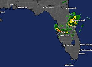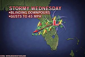
An area of disturbed weather in the Atlantic will bring heavy, gusty thunderstorms to part of the Florida Peninsula this afternoon and evening.
The feature, which started out as a cluster of thunderstorms over the Great Lakes this past weekend, blew off the mid-Atlantic coast Memorial Day morning.
That feature has now turned southwestward and will cross the Florida Peninsula from northeast to southwest this afternoon and evening.
Areas from Daytona Beach and Cape Canaveral will be impacted first. Next, Gainesville, Ocala and Orlando would be in the path of the stormy weather this afternoon. Finally, the Tampa, Sarasota and Fort Myers areas are fair game for some of the thunderstorms later today.
The system will not have enough time to develop tropically, but it may behave a bit like a tropical storm with a brief period of gusty winds and localized flooding downpours.
The thunderstorms associated with it may be strong enough to knock down a few trees and cause sporadic power outages. The storms can slow travel for a time along interstates 4, 75 and 95.
Aside from disturbing outdoor plans for a brief time today, the rain is welcome.
The system with its downpours will roll across some areas that were battling brush fires and an unusually long dry season.
Daytona Beach has only received a little over an inch of rain since April 1. This is far from adequate rainfall for an area with intense, year-round sunshine.
Many other areas in Florida have only received between 25 and 50 percent of their normal rainfall this spring, a season which typically yields lean rainfall.


I found this video posted yesterday quite interesting. it shows chemtrails being sprayed in the storms path to steer it inland...
[Link]