Another round of dangerous thunderstorms will sweep eastward across a large portion of the United States in the coming days, and this storm system will be accompanied by something that we may not have expected to hear about again until next winter -- a swath of accumulating snow.
The thunderstorms will pound areas that have been hit hard by severe weather during
what's been a very stormy month, spreading from the Plains on Thursday to the Southeast on Saturday. The snow will fall from the northern Rockies to the upper Midwest, with the chance for some late-season snow in parts of the interior Northeast over the weekend.
The most likely location to receive a disruptive amount of snow -- locally over 6 inches -- will be in western and central South Dakota from later Thursday through Friday, where the National Weather Service has issued
winter storm watches. The snow will accumulate more on unpaved surfaces than on roadways; however, travel will be disrupted, especially at night. The snow will be accompanied by winds that will reduce visibilities to under a half-mile.
The snow will begin today and tonight in an area where late-season snow is not uncommon -- the mountains of the Pacific Northwest and northern Rockies. Depending on the path of the storm, a second area of wet snow might develop in the higher elevations of upstate New York and New England later in the weekend.

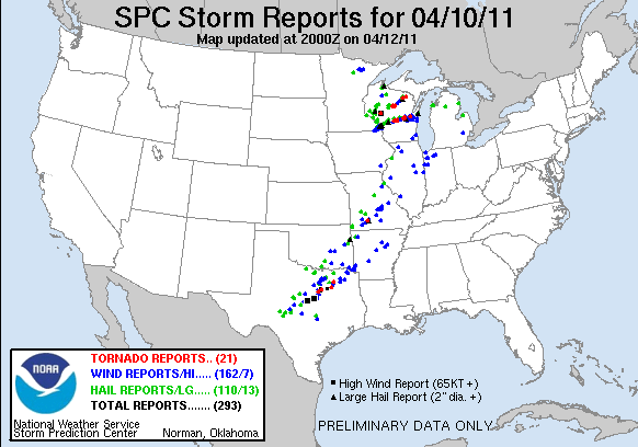
© Image courtesy of NOAASevere weather reports from last Sunday
The precipitation, whether rain, mixed rain and snow or only quickly melting wet snow, will add to existing flooding problems from the northern Plains and Northeast, since it will be added to rivers and streams that are already at or above flood stage.
The dangerous thunderstorms will not develop until the storm emerges onto the Plains on Thursday and Thursday night, with the potential for dangerous thunderstorms -- including wind damage, hail and isolated tornadoes -- in Kansas, Oklahoma, Missouri and Arkansas.
The potentially destructive thunderstorms will spread into the Midwest, Tennessee Valley and parts of the Deep South on Friday and into the Carolinas and mid-Atlantic region on Saturday.
This will be the third large storm system to produce dangerous thunderstorms over a large area from the Plains to the East Coast this month. According to the government's thunderstorm and tornado experts, the
Storm Prediction Center, there have been
nearly 3,000 preliminary severe-weather reports since April 1, including 115 tornado reports.This includes an early-month storm system that resulted in more than 1,600 reports of severe weather over a several-day span and a storm system last weekend that resulted in 53 preliminary reports of tornadoes across the Plains and Southeast.
This week's storm will not put an end to the stormy ride. Two similar storms -- the fourth and fifth of the month -- are expected to take a similar path across the country during the middle part of next week, according to computer forecast models.

Reader Comments
to our Newsletter