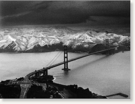
Talk began swirling in recent days that snow could drop on San Francisco for the first time in 35 years.
National Weather Service forecaster Bob Benjamin said that while snow would likely fall at elevations lower than last weekend, it was still too soon to know for certain if there would be flurries in the city.
If the coldest predictions materialize, "In some form, people at or near sea level will see snow in the air," Benjamin said.
A southern-moving unstable cold front carrying moisture was expected to coast into the Bay Area come late Thursday, Benjamin said.
The front was expected to sit over the Bay Area and by Sunday morning bring record-breaking cold temperatures, with 20s to lower 30s forecast over the North Bay valleys, upper 20s to lower 30s around most of the San Francisco Bay shoreline southward through the Santa Clara and Salinas valleys. Higher elevation spots were expected to mostly be in the 20s.
A Freeze Watch was issued by the weather service for late Friday night through Saturday morning for the North Bay valleys, which were expected to be the first to feel the effects of the arctic blast.
Last weekend, snow blanketed the Bay Area's highest peaks, dusting Mount Tamalpais and Mount Diablo as it descended to elevations of 1,500 feet. The storm system dumped about 4 inches of rain on San Francisco.
Benjamin said the coming front would drop snow at even lower elevations, but added that predictions of snow below 1,000 feet would be "hit or miss."
The weather service issued a Winter Weather Advisory for snow in the North Bay mountains from 4 p.m. Thursday to 10 a.m. Friday. Snow accumulations of 1 inch down to 1,000 feet with 2 to 4 inches above 1,500 feet elevation. Six inches or more for the higher hills above 2,500 feet.
A Winter Storm Watch was in effect from Thursday evening through Friday evening for elevations above 1,000 feet for the East Bay hills, the Santa Cruz Mountains and the mountains of Monterey County. Snow accumulations were forecast at 1 inch down to 1,000 feet with 3 to 6 inches above 2,000 feet elevation. Nine inches or more were possible for elevations above 3,000 feet.
Storms bring snow to downtown San Francisco every couple of decades, with the most recent recorded snowfall in 1976, Benjamin said.
Since then, the weather service has received reports of snow mixed with rain "most every year in some key places," such as Twin Peaks, Benjamin said.


Reader Comments
to our Newsletter