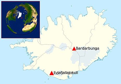
© unkMap: Bardarbunga is in a more central position north east from Eyjafjallajokull.
This past spring, while the eruption at Eyjafjallajokull was taking place, there was large scale earthquake activity at Bardarbunga. The increased seismic activity in the area then, and again just a couple of weeks ago, created a lot of discussion and deliberation. Bardarbunga is a big volcano under the Vatnajokull ice cap with a large ice-filled caldera some 6-700 metres deep and a lateral volcano at Hamar to the south of the main crater. Bardarbunga is a central volcano in the Icelandic volcano system. The system's fissure swarm stretches from the northeast to the southwest from the central highlands under the glacier; all the way from Tungnaa in the south to the lava fields west of Askja in the north. The system is over 100 kilometres long.
The northern part of the volcano lies under the Dyngjujokull outlet glacier and at Dyngjuhals, a ridge with crater rows and lava flow, cutting into the Odadahraun lava fields. The last eruption to take place there was in the second half of the 18th Century, both under Dyngjujokull and at Dyngjuhals. A Jökulhlaup (otherwise known as a glacier meltwater flood) ensued in the Jokulsa a Fjollum river. It is likely that Askja has not erupted in recorded history (since Iceland was settled), but volcanic activity at Gjalp in 1996, near to Bardarbunga, indicates it is part of the Grimsvotn system, according to the lava's chemical composition.
The southern part of the volcanic system is more active than the other half. Many large eruptions took place there in prehistoric times. Around the time of the settlement age in 870 AD, there was a powerful eruption (mainly tephra) and another powerful eruption cycle around 1480, with lava and tephra eruptions. The eruptions took place where there were a lot of lakes and many more were created in the craters, which are now popular trout fishing spots. The eruption fissure is around 40 kilometres long and the amount of volcanic material produced was huge, at some 1,500 million cubic metres. This volcanic activity on both occasions caused eruptions in the Torfajokull system and created, for example, the lava at Landmannalaugar.
It is often forgotten that an eruption took place near the present-day research station close to Tungnaarjokull, to the west of Vatnajokull, in 1862-64 - precisely in the southern part of the Bardarbunga system. It was not a particularly active series of eruptions, but the row of craters with a few separate sections is still 16 kilometres long, with many spatter and scoria craters and the lava field (Trollahraun) is around 30 square kilometres in area.
The next series of eruptions at Bardarbunga could of course happen anywhere, but the recent earthquakes indicate that an eruption could take place in a similar location to in the 18th Century. There are signs that magma is rising at great depth underneath the Bardarbunga volcanic centre. A future eruption under the glacier would be accompanied by a jökulhlaup, most likely in Kreppa and Jokulsa a Fjollum. Tephra would also likely be produced - possibly in large quantities.
There are also other possibilities, for example an eruption in the southern part of the system, but for now geologists at the Icelandic Meteorological Office are stressing that the earthquakes do not mean that an eruption is imminent.
Reader Comments
to our Newsletter