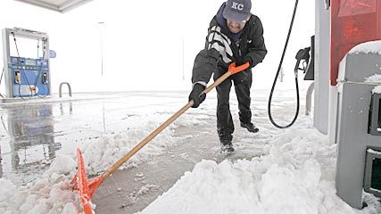
© Nam Y. Huh, APA man clears snow at a gas station in DeKalb, Ill., on Sunday.
Back-to-back storm systems and widespread cold will bring more harsh winter weather to the eastern two-thirds of the nation this week.
One storm will spread snow and rain along a path from the Tennessee Valley to the Northeast from today through Tuesday, while the next storm will bring significant snowfall to the central and southern Plains from late tonight into Wednesday.
Meanwhile, a new blast of arctic air will spread southward and eastward, with subzero low temperatures extending over a large area from the Plains to the Northeast on Tuesday night.
The first storm will be too disorganized to produce the type of intense snowfall that has been common so far this winter, but snow -- or rain changing to snow -- will occur from Arkansas to New England. Some travel delays may occur, especially from Arkansas to western and northern Kentucky, where communities do not have as much snow removal equipment, and in interior New England, where snow will accumulate up to several inches.
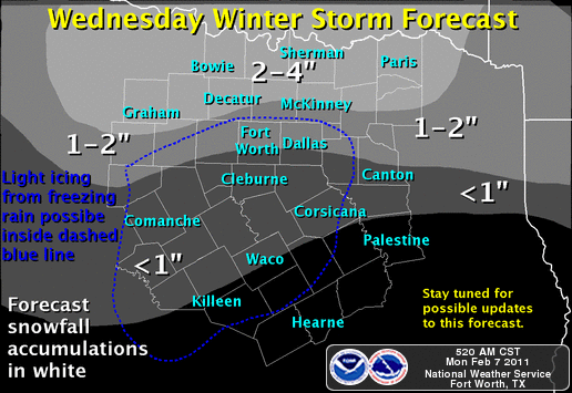
Sharply cold air will follow the passage of the storm, setting the stage for widespread bitter cold by Tuesday night and the likelihood of a significant accumulation of snow fairly far south into the Plains by Wednesday, including the Dallas region.
Winter storm watches are in effect in northern Texas and much of Oklahoma. Up to 10 inches of snow is expected in Oklahoma, where strong winds will create drifts of 2 to 3 feet.
Wind chill temperatures are expected to approach minus 30 in western Kansas from later Tuesday night into Wednesday.
Accumulating snow is likely to occur as far south as north-central Texas by Wednesday, marking the third accumulating snowfall in this region in the past two weeks.
© National Weather Service
Accumulating snow will likely spread eastward into Arkansas and northern Louisiana during the day Wednesday, and light snow or flurries are possible from northern Mississippi to the Carolinas Wednesday night as the storm weakens.
The cold air currently across the northern Plains and northern Rockies -- high temperatures today will remain below zero in parts of Montana and North Dakota -- will become more widespread across the Plains, upper Midwest and Northeast during the next couple of days.
Low temperatures on Tuesday night will be below zero from western Kansas to northern Illinois, including Chicago, and many locations in Nebraska and Iowa will have low temperatures of at least minus 10. In the Northeast, temperatures will approach minus 15 in the coldest locations in interior New England and upstate New York, with temperatures in the teens in New York City.
The colder than normal weather will continue from the Plains to the East through at least Thursday, with a significant warming trend across the Plains by late in the week. Warmer air will begin to move into the Northeast late in the weekend or early next week.


Reader Comments
to our Newsletter