This winter has brought 51.5 inches of snow to Boston, easily topping the city's winter average of 42.3 inches. The record snowfall for the city was experienced during the 1995-1996 winter when Boston was buried under 107 inches of snow. New York so far this winter has experienced 56 inches of snow, although its record was also experienced in 1995-1996 when 75 inches fell.
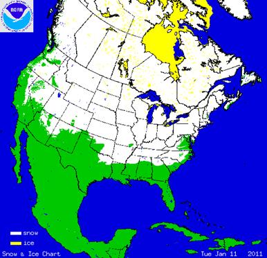
Besides the dramatic snowfall records this winter, average temperatures also have been colder than normal. Importantly, the winter weather has impacted much more of the United States than normal. On January 11th, every state except Florida had snow on the ground, including Hawaii where there were seven inches atop the dormant volcano Mauna Kea on the island of Hawaii. Slightly over 70% of the nation's aerial extent was snow covered that January day as shown in Exhibit 6.
Recent media articles have focused on the altered weather pattern that has been impacting Northern Europe and North America along with the Arctic for the past two winters. As we have written about, the polar vortex, a weather pattern that influences the location and movement of the jet stream, seems to have shifted bringing the cold weather. When there is a strong pressure difference between the polar region and the middle latitudes of the planet, the jet stream, a wind pattern that moves from west to east and normally across Canada, shifts into a tight circle around the North Pole and contains the frigid winter air at the top of the world. When that pressure differential shrinks, the jet stream weakens and drifts southward bringing cold air into the middle latitudes (the United States and Europe) and allowing warm air to move into the polar region. This pattern shift has happened intermittently over many decades; however, it has been unusual for it to weaken as much as it has in recent winters. Last year, one index had the vortex hitting the lowest winter-time value since record-keeping began in 1865. It was nearly that low last December.
Throughout the decade ending in the mid 1990s, the polar vortex was strengthening resulting in much warmer winters on average in Northern Europe and North America. This pattern led some climate change supporters to claim that global warming was responsible for the near end to traditional winter weather. Now that the pattern has reversed, and in a big way, climate change supporters are claiming that global warming is impacting the Arctic and is shrinking the Arctic sea ice cover, which contributes to the weakening of the pressure differential and the shift in the jet stream. Smarter climate change supporters are beginning to say it is too early to tell whether these weather changes are related to global warming, and certainly a two year timeframe is insufficient for overthrowing previous climate change theories dealing with the polar vortex.
AccuWeather.com's severe weather forecaster, Joe Bastardi, recently produced a video in which he offered an explanation for why his winter weather forecast missed the record snow and cold. He is both an entertaining and smart weather forecaster in our judgment. He firmly believes that natural forces help determine the weather and by seeking to find analog patterns in history is a way to understand the development and path of weather and storms.
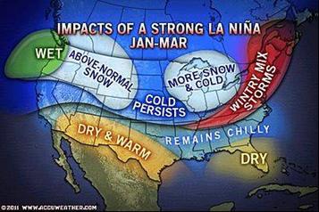
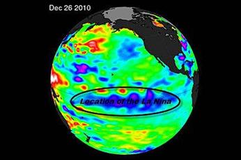
According to Mr. Bastardi, the changed weather pattern has a lot to do with La Niña, a weather pattern in the South Pacific Ocean that is associated with the cooling of the surface water and can alter the Northern Hemisphere's wind patterns bringing cooler and wetter weather to the U.S. and the Atlantic Basin. Mr. Bastardi has found that when there are back-to-back La Niña years, temperatures across the United States get progressively cooler. If the La Niña period is then followed by an El Niño, winters get even colder. He bases his conclusions on looking at the analog years for back-to-back La Niña years such as were experienced in 1949-50, 1954-55, 1973-74, 1998-99 and 2007-2008. In his view, "something is going on that is bigger than we understand."
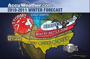
The original AccuWeather.com winter weather forecast for 2010-2011 called for winter to be focused primarily in the Midwest and Northeast. The severity of winter would be contested in the southern portion of these various states. It was expected that the southern tier of the U.S. would not experience much of a winter and that Florida would be warm.
Unfortunately, Mr. Bastardi's original forecast has proven to be way off base. The entire half of the country from the Plains states to the East Coast and south to the Gulf Coast has been treated to many ice and snow storms that have impacted and at times have paralyzed parts of the country, including disrupting the holiday travel plans for many Americans. The cold weather was so bad in December that it impacted the citrus crop in Florida with the resulting loss of fruit driving up orange juice futures and grocery store prices.
Atlanta, Georgia, has had 5.9 inches of snow so far this winter with two months still to go. That compares with the city's record winter snowfall of 10.3 inches in 1982-1983. Both Georgia and Florida recorded their lowest average December temperatures on record last month. So far in January, 155 daily snowfall records have been broken. Most of the records were in the Northeast but they stretch south to Louisville, Kentucky, and Wilmington, North Carolina.
The latest data for the Pacific Ocean show sea surface temperatures averaging 0.20 C cooler than the long-term average. Mr. Bastardi believes that since the Pacific Ocean is such a large body of water that when it cools the ocean sucks in much of the heat of the planet. This can lead to a cooler planet for an extended period of time as it will take a reversal of the weather cycle to warm the Pacific Ocean.
Mr. Bastardi has also become quite interested in sun spot activity. The current sun spot cycle (Cycle 24) is producing as few spots as last experienced during the late 1700s and early 1800s. Importantly, sun spot forecasts have been reduced in recent years. The absence of sun spots appears to correlate with colder temperatures on the planet. That is best demonstrated by the chart in Exhibit 10. As shown by the data, the Maunder Minimum period from 1645 to 1710, when there was an absence of sun spots, just happened to coincide with the extremely cold winters experienced in Northern Europe during pre-industrialized times and is referred to as the "Little Ice Age."
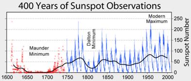
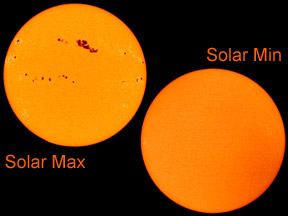
Sun spot cycles have demonstrated considerable variability during their life, ranging from as short as nine years in length to as long as 14 years. The average length of sun spot cycles is about 11 years. Exhibit 12 shows two pictures of the sun - the sun on the left has many sun spots while the one on the right has none. The left picture shows the Solar Maximum while the right picture shows the Solar Minimum. Today's sun looks more like the Solar Minimum picture.
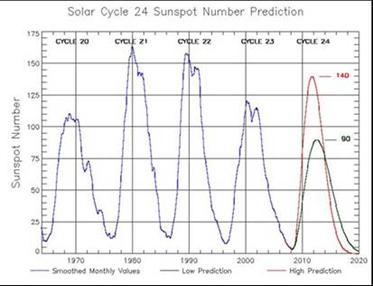
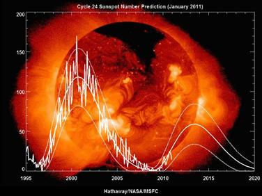
The original sun spot forecast for Cycle 24 was issued in 2006 and it was recently revised and is shown in Exhibit 13. It now calls for a peak in the count to be somewhere around 85 with a low count of about 35. The central value is estimated to be 59, which is well below the low end of the prior sun spot forecast of 90. In the video, while Mr. Bastardi discusses the fact that he believes the world is moving into a period of global cooling, he says he doesn't believe in the sun spot theory completely because he doesn't know enough about it and how it might be interacting with the other driving factors behind climate change. He doesn't rule it out, either.
Mr. Bastardi also mentions that in the early 1990s at the time of Glasnost, there were several scientific papers written by Russian astrophysicists arguing that the upcoming sun spot cycle (Cycle 24) might see the count fall to close to zero. These scientists, therefore, believed that the planet was heading into another "little ice age." Mr. Bastardi disavows that forecast but acknowledges that there is "something going on that we haven't seen before" and that it is happening "on the cold side, and not the warm side." He points to the Pacific Decadal Oscillation (PDO) that is producing the cooling Pacific Ocean waters and the La Niña weather pattern. There is also the dramatic drop in sun spot activity. He believes these natural forces are just as important to determining the future of the planet's climate as carbon dioxide emissions and Anthropogenic Global Warming (AGW) factors. As Mr. Bastardi puts it in summing up the importance of the four drivers for the weather he just identified, "one of these Emperors has no clothes" and we will find out in the near future, which one it is. It will be interesting to see how much money is allocated in the Obama administration's next budget proposal for research on global cooling.
Source: Parks Paton Hoepfl & Brown


to no the future one should look at past.cycles are everything.
the sun, magnetic pole shift, our solar system place in our galaxy .do we measure magnetics in snow?