The satellite data continues to collect and has been archived since 2002 for the Terra satellite and since 2003 for a similar satellite, known as Aqua. The Fairbanks station picks up information from the these satellites about 15 times a day. The machines circle the earth from pole to pole every 108 minutes.
Here is what NASA says about the image:
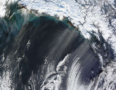
Dust storms generally call to mind places like the Sahara Desert or the Arabian Peninsula, but dust storms occur at high latitudes as well. One such storm left streamers of dust over the Gulf of Alaska in mid-November 2010. The Moderate Resolution Imaging Spectroradiometer (MODIS) on NASA's Terra satellite captured this natural-color image on November 17, 2010. Thin plumes of beige dust blow off the Alaskan coast toward the south-southwest. Roughly mimicking the shape and direction of the dust plumes, parallel lines of clouds occur farther south over the ocean.
Malaspina is just one of many glaciers fringing the Alaskan coastline. As glaciers grind over rocks, the rivers of ice pulverize some of the rock into glacial flour. Meltwater percolating through glaciers often deposits glacial flour in mud plains. When the sediments on these plains dry out, winds sometimes carry dust particles aloft.Here is a link to the NASA site.
The cloud streets in the south cast shadows on the dust plumes below. Running in the same direction as the dust plumes, they are likely shaped by the same winds.


Reader Comments
to our Newsletter