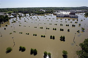
Slow-moving showers and thunderstorms today are pushing through middle Tennessee, an area that definitely doesn't need any more rain. The region is still recovering from the devastating flooding that took place earlier in the month, and the rain today could cause renewed flooding in some areas.
Other states surrounding Tennessee will also be at risk for flash flooding through this evening as slow-moving showers and thunderstorms also affect Arkansas, Mississippi, Alabama, Kentucky and southern Missouri.
It's important to stress that today's event will not be anything like the one that occurred at the beginning of the month with over 13 inches of rain falling in Nashville over the span of just two days. An event like that is quite rare.
Rainfall totals today are only expected to average between an inch or two, though a few places could pick up 3 to 5 inches. While not as extreme, rainfall on this order is still well-capable of causing creeks and streams to quickly rise out of their banks and flood surrounding areas.
Low-lying and urban areas will also be susceptible to flooding.
As tragically demonstrated earlier this month, flash flooding can claim lives. Never attempt to drive across a road covered with water.
Cities at risk for flash flooding through this evening include Louisville and Paducah, Ky., Cape Girardeau, Mo., and Nashville, Tenn.
The heaviest rain and thunderstorms are expected to move into areas farther north and northeast tonight, potentially affecting Springfield, Ill., Cincinnati, Ohio, and the Indianapolis area.


Reader Comments
to our Newsletter