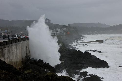
The new assessment concludes that the highest waves may be as much as 46 feet, up from estimates of only 33 feet that were made as recently as 1996, and a 40 percent increase. December and January are the months such waves are most likely to occur, although summer waves are also significantly higher.
In a study just published online in the journal Coastal Engineering, scientists from Oregon State University and the Oregon Department of Geology and Mineral Industries report that the cause of these dramatically higher waves is not completely certain, but "likely due to Earth's changing climate."
Using more sophisticated techniques that account for the "non-stationarity" in the wave height record, researchers say the 100-year wave height could actually exceed 55 feet, with impacts that would dwarf those expected from sea level rise in coming decades.
Increased coastal erosion, flooding, damage to ocean or coastal structures and changing shorelines are all possible, scientists say.
"The rates of erosion and frequency of coastal flooding have increased over the last couple of decades and will almost certainly increase in the future," said Peter Ruggiero, an assistant professor in the OSU Department of Geosciences. "The Pacific Northwest has one of the strongest wave climates in the world, and the data clearly show that it's getting even bigger.
"Possible causes might be changes in storm tracks, higher winds, more intense winter storms, or other factors," Ruggiero said. "These probably are related to global warming, but could also be involved with periodic climate fluctuations such as the Pacific Decadal Oscillation, and our wave records are sufficiently short that we can't be certain yet. But what is clear is the waves are getting larger."
In the early 1990s, Ruggiero said, a fairly typical winter might have an offshore wave maximum of a little more than 25 feet. It was believed then -- based primarily on data from two offshore buoys -- that 10 meters, or 33 feet, would be about as large as waves would ever get, even in a massive "100-year" storm.
But then a major El Nino -- which tends to bring larger waves, higher water levels and increased erosion -- happened in 1997-98 and led to a string of "100-year" wave events of around and above 33 feet. Researchers went back to the drawing board, continued to study data and storm events, and now believe that the maximum waves the region may face could approach or even exceed 50 feet.
Increasing wave heights, they said, have had double or triple the impact in terms of erosion, flooding and damage as sea level rise over the last few decades. If wave heights continue to increase, they may continue to dominate over the acceleration in sea level that's anticipated over the next couple of decades. The prior concern about what sea level rise could do, in other words, is already a reality. If sea levels do increase significantly in future decades and centuries, that will only add to the damage already being done by higher waves.
Exactly what impacts this will have in terms of beach erosion and shifting shorelines is difficult to predict, scientists say, because currents and sand move in complex ways, creating both "winners and losers" in terms of beach stability. But some effects are already visible, Ruggiero said.
"Neskowin is already having problems with high water levels and coastal erosion," Ruggiero said. "Some commercial structures there occasionally lose the use of their lower levels.
"Going to the future, communities are going to have to plan for heavier wave impacts and erosion, and decide what amounts of risk they are willing to take, how coastal growth should be managed and what criteria to use for structures," he said.
Hampering the research effort is the fact that two of the major buoys used for these studies, which are some distance off the Pacific Northwest coast and measure waves in deep water, were only installed in the 1970s. Even at that they provide two of the longest high-quality wave height records in the world. OSU researchers are studying historical records through climate data, old newspaper records and other information to try to recreate what wave heights and storm events were like going further back in time.
The largest wave height increases, scientists say, have occurred off the Washington coast and northern Oregon, with less increase in southern Oregon and nothing of significance south of central California. The study also noted that similar increases in wave heights have occurred in the North Atlantic Ocean, as well as the seasonal total power generated by hurricanes.
These issues do not consider the potential drop in land level that is expected to occur in this region with a subduction zone earthquake at some point in the future. Ruggiero noted that he did some research in Sumatra following the huge 2004 earthquake there -- an area with geology very similar to that of the Pacific Northwest -- and some of the shoreline had dropped from 1.5 to five feet. If and when that occurs, the impacts on shorelines could be enormous.
This research was supported by the Sectoral Application Research Program, a part of the Climate Program Office at the National Oceanic and Atmospheric Administration.


Waves reached 45+ feet this winter on the North facing shores of Oahu. The last time residents saw waves this big was back in 2005. Over the past month the Civil Defense closed roads and warned residents that the waves were so large that they were crossing the highway that surrounds the island of Oahu.