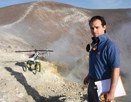
A large toy helicopter could help to predict volcanic eruptions in time to safely evacuate the surrounding area, according to geophysicists who have just been awarded $100,000 to develop their idea.
When fresh, eruption-ready magma arrives deep in the heart of a volcano, it tends to release carbon dioxide. As the magma rises, it also pushes sulfur dioxide out of the volcano. Spotting changes in the ratio of these gases around a volcano should indicate whether it is about to blow - but although sulfur dioxide is routinely measured by vulcanologists, taking carbon dioxide measurements is a much bigger challenge.
Carbon dioxide levels in the atmosphere are incredibly high compared to levels of sulfur dioxide. "So the component that the volcano adds to [the background carbon dioxide levels] is, relatively speaking, next to nothing," says Andrew McGonigle, a geophysicist from the University of Sheffield, UK.
In order to take the precise carbon dioxide measurements needed to tease out the volcano's contribution, vulcanologists have previously had to place gas sensors in the highly dangerous areas where the gas is released. In 1993, six vulcanologists died when Galeras, a volcano in Colombia, erupted while they were trying to take gas measurements.
To avoid similar tragedies, McGonigle is developing an unmanned aerial vehicle (UAV) to fly under the plume of an active - but not yet erupting - volcano to take those telltale carbon dioxide measurements.
McGonigle showed that this could be done earlier this year when he flew a small radio-controlled helicopter to take carbon dioxide measurements at Vulcano, Italy1. Today, Swiss watch company Rolex named McGonigle one of five laureates of their annual enterprise awards.
McGonigle plans to use the cash to help his idea take off. "That helicopter can only fly about 400 metres away from the operator," McGonigle says of his first efforts. "What's required is a really up-to-date UAV in order to make this technology useful."
Danger zone
Stanley Williams, a vulcanologist at Arizona State University, was the only survivor from the Galeras accident, and has faced criticism for leading the team of scientists into the crater. Williams says he hopes McGonigle's efforts will be successful, because having carbon dioxide as well as sulfur dioxide data will make volcano predictions easier. "Measuring two different things is always better than just one," says Williams. But he is sceptical whether a small UAV could be ever be operated at a safe enough distance from some of the world's most dangerous, unpredictable volcanoes.
UAVs hold promise for many scientific applications, and they have been used in Antarctica to take photos and measurements in places too remote for humans to access. But these flying robotic scientists are hampered by regulatory and political problems (see Flying robots have their wings clipped). Nevertheless, McGonigle would like to see his technology, once fully developed, given to local authorities in countries at risk of an eruption to help predict volcano activity.
Using the Rolex money he will buy and kit out his next UAV - probably another helicopter - to carry up to five kilograms of sensors back and forth through the gas plume.
If governments grant permission for the UAVs to fly, the technology could be a great help to geoscientists, says Tamsin Mather, an earth scientist from the University of Oxford, UK. "Using a UAV will allow a greater range of volcanoes to be monitored."
References
1. McGonigle, A. J. S. et al. Geophys. Res. Lett. 35, L06303 (2008) doi:10.1029/2007GL032508


Reader Comments
to our Newsletter